Zur Beachtung
Um die Anforderungen an diesen Earthcache zu erfüllen, muss man nicht das umzäunte Gelände betreten. Das Außengelände mit den Informationstafeln kann 24/7 besucht werden.
Attention
to get credit for this cache you do not have to enter the fenced area. All information can be found in the surrounding area which can be accessed 24/7.
Discover Earth history and nature in a fascinating territory
The Geopark
The Geopark territory of the area takes in approximately 3500 km², between the Rhine valley in the west and the Main valley in the east. The region is bounded to the south by the Neckar valley and to the north by the UNESCO World natural heritage Messel pit.
The Geo-Nature-Park Bergstrasse-Odenwald is situated in the northern part of Baden-Wuerttemberg, Germany, just 3 Km north of Heidelberg. From the B3, between Heidelberg and Dossenheim, follow the road up the hill all the way to the parking area at N49 26.862 E008 40.870. From here, walk to the Viepoint at N49 26.854 E008 41.115 via waypoint N49 26.830 E008 40.922, altitute change about 130 feet (40 Meters)
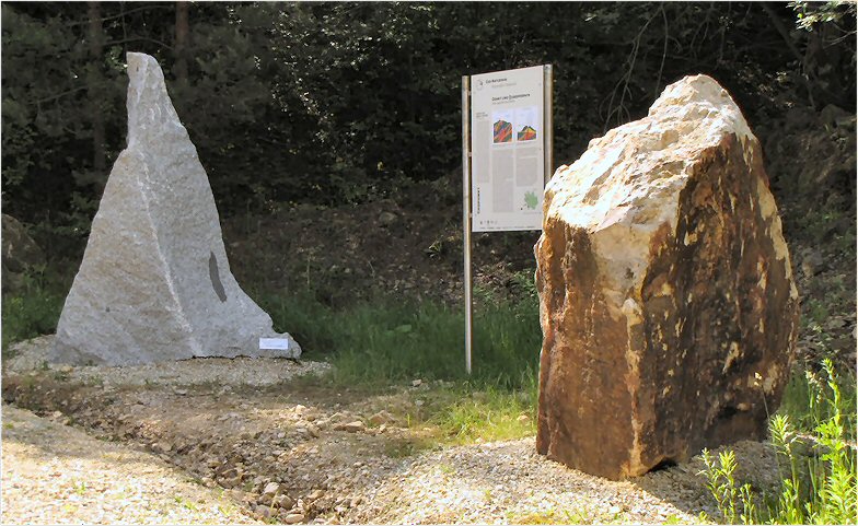
The Unlike Sisters
The composition of granite and quartz porphyry is very similar. Both contain quartz, Feldspat and mica but they look quite different from each other: Granite consists of a mixture of colored mineral grains, which are easily seen by the naked eye. In contrast quartz porphyry is made of visible quartz and Feldspat crystals dispersed in a very fine matrix.
How can this difference be explained since both rocks are formed from magma at 650°C? In one case the magma cooled rapidly on the Earth’s surface after a volcanic eruption – there was no time to form large crystals. The result is the fine-grained rhyolite, which was once extracted here in this abandoned quarry. In the other case, the magma cooled very slow at 10 to 15 Km beneath the Earth’s surface – plenty of time to form large crystals.
Requirements for claiming this Cache
To get credit for this EarthCache please email us your answer to the Study Questions below which can be found on the information boards along the way to he top. You do not have to wait for a log permission. It would be nice if you post a picture of the Dossenheim Quarry or one of the unique objects around here in the background. Please do not post any answers with your log.
1. What are rocks such as granite called, which forms by magma cooling at great depths?
2. What are rocks called, developed from magma cooling on the earth's surface?
3. Here at Dossenheim, the rhyolite rests on top of the granite - a volcanic rock on top of a rock that was formed 10 to 15 Km deep in the earth's crust. Explain in your own words what happened here millions of years ago.
4. How many tons of rock were produced by the Leferenz quarry in 1925?
5. What two tools were used until the 19th century to extract the rocks?
Voraussetzungen um diesen Cache zu loggen
Bitte beantworte folgende Fragen die auf den Infotafeln entlang des Weges nach oben zu finden sind, und sende uns die Antworten per email. Danach kann direkt geloggt werden, man muss nicht mehr auf eine Logerlaubnis warten. Es wäre super, wenn du ein Bild deinem Online-Log beifügen würdest, das eines der typischen Gegenstände hier zeigt.
1. Wie bezeichnet man Gesteine die in großer Tiefe aus Schmelzen erstarren?
2. Wie bezeichnet man Gesteine die in an der Erdoberfläche erstarren?
3. Heute liegen hier Rhyolith und Granit unmittelbar übereinander. Beschreibe in deinen eigenen Worten was hier vor Millionen von Jahren geschah.
4. Wie viele Tonnen Gestein wurden im Jahre 1925 im Steinbruch Leferenz gebrochen?
5. Mit welchen beiden Werkzeugen wurden bis ins 19. Jahrhundert die Felsbrocken aus der Wand gelöst?
Geology
Millions of years ago… the geological heritage
The Geopark territory includes a unique sequence of more than 500 million years of eventful Global history in the centre of Europe. This is already indicated in the motto of the Geopark: “Between Granite and Sandstone – Continents on the move“. Solely in central Europe, the region between Rhine, Main and Neckar exposes not just a great variety of crystalline and sedimentary rocks, but also the tracks of two major global events: a former continental collision the Oberrheingraben as part of a European wide tectonic structure. Thus, this region provides an unique window into Earth‘s history, that gives insight in the dynamic processes of our planet. These will become comprehensible on the one hand through the hereby grown typical rock formations, on the other hand by the characteristic landscape morphology and agriculture.
Other Information
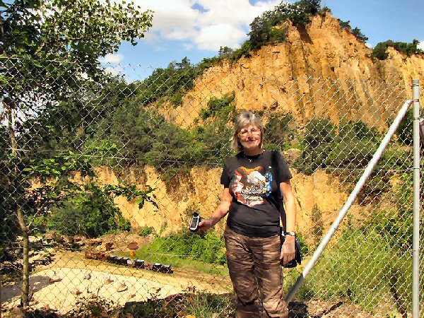
History of the Dossenheim Quarries
The extraction of porphyry in Dossenheim began around 1760 as a response to the growing need for road construction materials. The first quarry at the Kirchberg expanded continuously until 1834. From 1890/1898, cableways replaced horses and cart and connected the quarries with the terminal on the main road. Before WW1, the main quarry at the Sporenberg was the largest porphyry producer in the State of Baden, producing 184,000 m3 of stones. Over 400 workers worked in the quarries of Dossenheim.