Höllentrichter bei Osterdorf EarthCache
Höllentrichter bei Osterdorf
-
Difficulty:
-

-
Terrain:
-

Size:  (not chosen)
Please note Use of geocaching.com services is subject to the terms and conditions
in our disclaimer.
English description see below.
 Deutsche Version
Höllentrichter bei Osterdorf
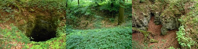
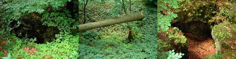
Auf der Jurahöhe zwischen Osterdorf und Treuchtlingen finden sich
an einem Waldrand zahlreiche zumeist trichter- oder schüsselförmige
Vertiefungen im Boden. Die meisten haben einen Durchmesser von drei
bis vier Metern und sind nicht allzu tief, manche sind aber auch
größer oder erreichen Tiefen von bis zu 20 Metern. Bei diesen
Trichtern handelt es sich um Dolinen.
Der Volksmund nennt diese Dolinen Höllentrichter, man
spricht aber auch von den Teufelslöchern oder Osterdorfer
Löchern.
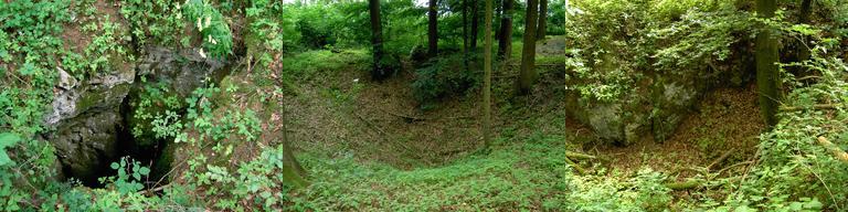
Hier bei Osterdorf findet sich ein Dolinenfeld, bestehend aus etwa
80 Löchern auf engem Raum. Sechs von ihnen sind als Schächte
ausgebildet, die auf menschliche Bearbeitung schließen lassen. Es
wird vermutet, dass hier bereits in der Hallstattzeit (750-500 v.
Chr.) von den Kelten und bis ins frühe Mittelalter bohnerzhaltiger
Lehm gefördert und zu Eisen geschmolzen wurde.
Entstehung von Dolinen
Das Wort Doline ist abgeleitet von dolina, dem slovenischen
Wort für Tal.
Als Dolinen oder Karsttrichter werden schlot-, trichter- oder
schüsselförmige Senken von meist rundem oder elliptischem Grundriss
bezeichnet. Sie entstehen durch Lösung und Ausspülung des
Oberflächengesteins durch Regenwasser, das durch einen Spalt in den
Gesteinskörper eindringen kann, oder indem das abfließende Wasser
vorhandene Lockermassen abspült.
Im Gegensatz dazu ist ist der sogenannte Erdfall auf den Einsturz
eines Hohlraums unter der Erde zurückzuführen, etwa weil die Decke
einer Höhle instabil ist oder infolge tektonischer Bewegungen.
Häufig handelt es sich bei den Erdlöchern aber um eine Mischform
von Doline und Erdfall.
Als senkrecht oder schräg in den Untergrund führende Schächte
münden Dolinen oft in Höhlen.
So findet ihr die Höllentrichter
Nehmt auf der Bundesstraße B 2 zwischen Dettenheim und Dietfurt die
Abzweigung nach Pappenheim (N 48° 57.325 E 010° 56.295). Nach knapp
einem Kilometer (N 48° 57.000 E 010° 56.840) haltet euch Richtung
Osterdorf und biegt nach der Kläranlage noch vor Erreichen des
Ortes nach links ab (N 48° 57.035 E 010° 57.095). Dem Feldweg könnt
ihr bis zu den Parkkoordinaten (N 48° 57.280 E 010° 56.770)
folgen.
Vom Parkplatz aus folgt dem Wanderweg am Waldrand entlang bis etwa
N 48° 57.580 E 010° 57.065 und dringt dort nach Westen in den Wald
ein. Gut gepflegte Waldwege gibt es hier leider nicht, die ganze
Gegend kann ziemlich zugewachsen sein. Die Gesamtstrecke hin und
zurück beträgt etwa zwei Kilometer.
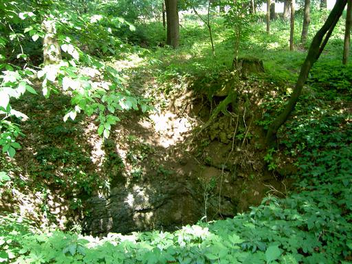
Im Bereich der Listing-Koordinaten finden sich zahlreiche Dolinen
in weitem Umkreis. Jeweils drei tiefere Schächte findet ihr um N
48° 57.570 E 010° 56.995 und N 48° 57.590 E 010° 57.020. Diese
beiden Bereiche sind wegen der Absturzgefahr eingezäunt; bitte
klettert zur Erfüllung der Logbedingungen nicht über die
Umzäunungen!
Logbedingungen
 1. Macht ein Foto von euch und
eurem GPSr mit einer beliebigen, aber erkennbaren der hier zu
findenden Dolinen im Hintergrund.
1. Macht ein Foto von euch und
eurem GPSr mit einer beliebigen, aber erkennbaren der hier zu
findenden Dolinen im Hintergrund.
2. Überlegt euch, was der Grund dafür sein könnte, dass hier so
viele Dolinen auf einer eng begrenzten Fläche zu finden sind.
3. Geht zu den Koordinaten N 48° 57.588 E 010° 57.015 und schätzt
den Durchmesser des dortigen Schachtes (siehe Foto).
4. Sendet eure Antworten auf die Fragen 2 und 3 an Hafelja.
5. Fügt eurem Log das Foto aus Aufgabe 1 hinzu.
 English Version
Höllentrichter near Osterdorf
Höllentrichter consists of the German words Hölle
(English: hell; German plural: Höllen) and Trichter (funnel;
in this case in the meaning of pit). Sometimes the Höllentrichter
are also called Teufelslöcher (the German word Teufel
means devil, Löcher means holes) or Osterdorfer
Löcher (Holes near Osterdorf).
On the Jura height between Osterdorf and Treuchtlingen you can find
numerous mostly funnel-shaped or bowl-shaped deepenings in the
ground. Their diameter mostly is about three or four meters and
they aren’t very deep. But some even are bigger and reach a
deepness of about 20 meters. These funnels are in fact
dolinas.
People call these dolinas Höllentrichter, Teufelslöcher or
Osterdörfer Löcher.
The field of dolinas near Osterdorf counts about 80 holes on
narrowest area. Six of these holes are developed as shafts, which
may be sign of human treatment. It is suspected that in the
Hallstatt period (750-500 B.C.) by Kelts and until the early Middle
Ages people mined clay there which contained bean ore they melted
down to iron.
Developement of dolinas
The word dolina is derived from the Slovenian word for
valley.
As dolinas or sinkholes people name cylindrical-shaped,
funnel-shaped or bowl-shaped depressions of mostly round or oval
outline. They are formed by solution and washout of the rock on the
surface by rainwater, which intrudes through a slit into the rock,
or they form through effluent water which rinses loose
material.
Contrary to this the so called sinkhole is to be traced back to the
fact that a hollow collapsed underground, for example because of an
instable ceiling or as a result of tectonic movement. But these
holes often are a hybrid of dolina and sinkhole.
As vertical or diagonal funnels dolinas often lead into
caves.
How to find the Höllentrichter
Take on the B2 federal road between Dettenheim and Dietfurt the
turnoff to Pappenheim (N 48° 57.325 E 010° 56.295). After about a
kilometer (N 48° 57.000 E 010° 56.840) drive to the direction of
Osterdorf. There after the waste water treatment plant turn to your
left before you even reach the village (N 48° 57.035 E 010°
57.095). Follow the path to the parking coordinates (N 48° 57.280 E
010° 56.770).
From the parking area you follow the hiking trail along the edge of
the forest until N 48° 57.580 E 010° 57.065 and then enter the
woods into the west. There are no real forest tracks there and the
area can be pretty overgrown. The whole track there and back again
is about 2 kilometers.
In the area of the earthcache coordinates you can find numerous
dolinas. There are three deeper funnels you can discover around N
48° 57.570 E 010° 56.995 and also around N 48° 57.590 E 010°
57.020. These two areas are fenced because of the danger of falling
down there. Please do not cross over the fence to fulfill the
logging conditions!
Logging Conditions
1. Take a foto of you and your
GPSr with one of the dolinas there of your choice in the
background. (The dolina must be recognizable!)
2. Think about the reason why there could have developed so many
dolinas on such a small area.
3. Walk to the coordinates N 48° 57.588 E 010° 57.015 and estimate
the diameter of the funnel there (see photo).
4. Send your answers for task 2 and 3 to Hafelja.
5. Add the foto of task 1 to your log.
Additional Hints
(No hints available.)