deutscher Text unten -
English text below
Italiano:
«Dopo un lungo periodo caratterizzato da un clima sub
tropicale, a partire dall’epoca quaternaria la temperatura si
abbassò di una diecina di gradi. Quattro periodi glaciali,
interrotti da periodi interglaciali, caratterizzarono il clima
della regione alpina e molte zone dell’emisfero boreale. L’ultima
glaciazione, quella del Würm, ha modellato il rilievo pre-glaciale
della Valposchiavo, dando ad essa un aspetto morfologico nuovo. Le
colate glaciali del versante sud-alpino spinsero la loro fronte
fino ai margini della Pianura Padana, dando origine, tra gli altri,
ai laghi di Garda, Iseo, Como, Maggiore e Lugano.
In seguito ad un miglioramento climatico i ghiacciai
incominciarono a ritirarsi verso le regioni più elevate della
catena alpina. Questo ritiro avvenne in fasi successive,
caratterizzate da oscillazioni positive e negative della fronte del
ghiacciaio. Le fasi di ritiro vennero studiate da C. Burga per la
Valposchiavo e da L. Huysmans per la Valle di Campo.
Per lo stadio denominato Valtellina II, il ghiacciaio poschiavino
aveva uno spessore di circa 1’200 m, documentato da una morena,
situata a 2’230 m. Per la Valle di Campo L. Huysmans ha trovato,
nella zona di Buril, ben otto valli morenici che corrispondono ad
altrettante fasi di ritiro.
Per Cavaglia è importante il deposito dello stadio “Egesen”, che
risale all’epoca pre-boreale, anteriore di 11’000 anni all’epoca
attuale. In questo periodo il limite delle nevi persistenti si
trovava circa a 300 m sotto il livello attuale. A partire dallo
stadio “Egesen” il clima migliorò sensibilmente e i ghiacciai si
ritirarono nelle più alte regioni delle Alpi. Si suppone che nel
periodo chiamato “Atlantico” la vegetazione si sia di nuovo
insediata nelle più alte regioni della catena alpina.
Circa 4’000 anni fa il clima si fece più rigido e i ghiacciai
ripresero a scendere lungo la parte superiore delle vallate. Fino
ad oggi si contano ben sedici oscillazioni positive a partire dal
“Finiglaciale”. Nel 1850 i ghiacciai raggiunsero la massima
espansione, dopo quella dello stadio “Egesen”. Il ghiacciaio del
Cambrena si spingeva fino al lago Bianco, quello del Palü aveva
invaso il pianoro dell’alpe Palü e quello del Morteratsch era alle
porte dell’attuale stazione ferroviaria. È da notare che i
ghiacciai Cambrena e Palü sono avanzati fra il 1965-1985, mentre
quello del Corno di Campo è sempre stato in fase di ritiro. Il
Vedreit da Dügüral, che negli anni cinquanta vantava una superficie
con bellissimi crepacci, è ora quasi scomparso».
(Aldo Godenzi, www.ghiacciai.info)
traduzione in progresso, grazie per la vostra
pazienza
Deutsch:
«Nach einer langen, durch ein subtropisches Klima
charakterisierten Periode ist die Temperatur ab Beginn des Quartärs
um Dutzende von Graden gesunken. Vier Eiszeiten – von
Zwischeneiszeiten unterbrochen – kennzeichnen das Klima der
Alpenregion und vielen Zonen der nördlichen Hemisphäre. Die letzte
Vereisung – die des Würm – hat die voreiszeitliche Erhebung des
Valposchiavo geformt, in dem sie ihr ein neues morphologisches
Aussehen gab. Die Gletscherströme des südlichen Alpenhanges schoben
ihre Stirn bis in die Poebene, unter anderem den Lago di Garda,
Lago d’Iseo, Lago di Como, Lago Maggiore und den Lago di Lugano
bildend.
Infolge einer klimatischen Erwärmung begannen sich die Gletscher
in die höheren Regionen des Alpenkamms zurückzuziehen. Dieser
Rückzug erfolgte etappenweise, durch positive und negative
Schwankungen charakterisiert. Diese Rückzugsphasen wurden von C.
Burga für das Valposchiavo und von L. Huysmans für das Valle di
Campo studiert.
Im Valtellina II genannten Stadium hatte der Puschlaver-Gletscher
eine Dicke von 1’200 m, bezeugt durch eine Moräne auf 2’230 m. Für
das Valle di Campo hat L. Huysmans in der Zone von Buril gut acht
Moränentäler gefunden, welche anderen Rückzugsphasen
entsprechen.
Wichtig für Cavaglia sind die Ablagerungen des „Egesen“, welche
auf die vorboreale Epoche zurückgehen, 11’000 Jahre vor der
heutigen Zeit. In dieser Periode lag die Grenze des „ewigen
Schnees“ ca. 300 m unter dem aktuellen Niveau. Ab dem „Egesen“
verbesserte sich das Klima merklich und die Gletscher zogen sich in
höhere Alpenregionen zurück. Man vermutet, dass sich die Vegetation
in dieser „atlantisch“ genannten Periode von neuem in den höheren
Regionen der Gebirgskette festgesetzt hat.
Vor ca. 4’000 Jahren wurde das Klima rauher und die Gletscher
begannen wieder die oberen Täler herabzufliessen. Bis heute zählt
man gut 16 positive Schwankungen seit der „Endeiszeit“. 1850
erreichten die Gletscher die grösste Ausdehnung nach den „Egesen“.
Der Gletscher des Cambrena stiess bis zum Lago Bianco vor,
derjenige des Palü hatte die Ebene derAlpe Palü überdeckt und der
Morteratschgletscher endete bei der heutigen RhB-Station. Es bleibt
anzumerken, dass die Gletscher Cambrena und Palü 1965-1985
vorgedrungen sind, während sich derjenige des Corno da Campo stets
in der Rückzugsphase befand. Der Vedreit da Dügüral, der in den
50er Jahren eine Oberfläche mit sehr schönen Spalten hatte, ist
heute beinahe verschwunden».
(Aldo Godenzi, auf www.ghiacciai.info)
Heute sind von den Gletschern selbst nur noch Reste übrige,
welche im Moment auch mehr und mehr wegschmelzen. Interessante
Daten hierzu liefert auch der Earthcache »Glacier Morteratsch /
Morteratsch Gletscher«
(
GC1H7EQ) von Bobi Bohne.
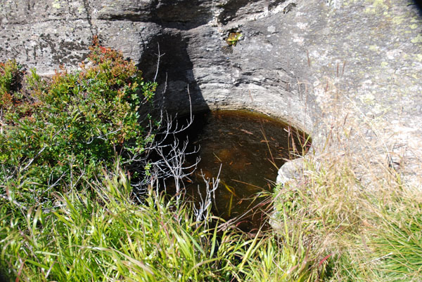
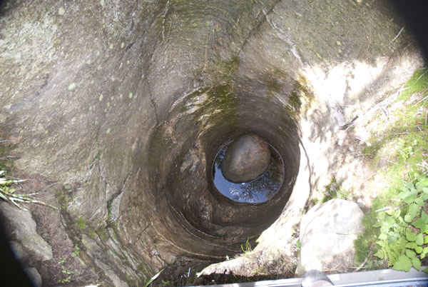
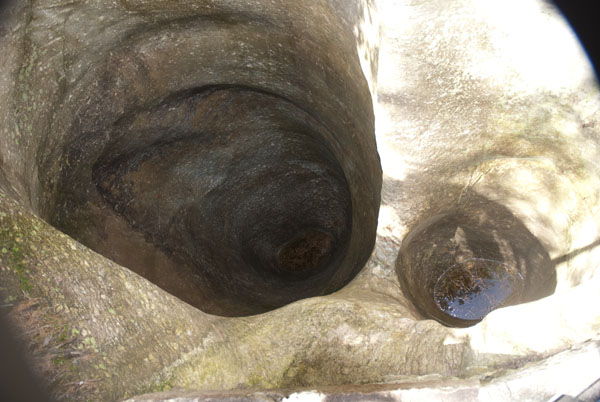
Was zurückbleibt sind die durch die Gletscherströme geschaffenen
Geländeformen und die Töpfe der Riesen, wie sie im Volksmund
genannt wurden, die Gletschertöpfe. Diese durch die Gletscher
geschaffenen Löcher im Gestein sind heute vielerorts nicht mehr
sichtbar, da sie im Laufe der Jahre durch Erosionsmaterial und die
Vegetation wieder aufgefüllt wurden.
Hier in Cavaglia wurden die Töpfe der Riesen zuerst von
Pfadfindern wieder freigelegt, später halfen Lehrlinge der RhB
(rätischen Bahn) mit, und schlussendlich wurde ein Verein
gegründet, welcher sich um die Gletschertöpfe kümmert. Es werden
neue Töpfe freigelegt, die bereits freigelegten mit Wegen
erschlossen und die erschlossenen Töpfe, die wasserdicht sind,
regelmässig vom Regenwasser befreit.
So kann man heute während des Sommers den Gletschergarten von
Cavaglia besichtigen. Der Eintritt ist frei, eine freiwillige
Spende für den weiteren Unterhalt wird jedoch an den beiden Kassen
bei Ein- und Ausgang gerne entgegengenommen.
Der Gletschergarten ist vom Bahnhof Cavaglia in 10 Minuten zu Fuss
erreichbar. Ich empfehle die Anreise der Bahn oder verbinde den
Besuch mit einer der vielen Wanderrouten. Die Anreise per Auto ist
zwar möglich, es hat an den Koordinaten auch einen Parkplatz, aber
es geht über enge Alpstrassen, weswegen ich diese Art der Anreise
nicht empfehle.
Die Gletschertöpfe entstanden durch (Schmelz-)Wasser, das durch
eine Spalte zum Gletscherbett abfloss. Das Wasser war am
Gletscherbett bis zu 200 km/h schnell und stand unter hohem Druck.
An gewissen Stellen am Gletscherbett entstanden Wasserwirbel. Wo
diese Wirbel entstanden, erodierten der mitgeführte Sand und Kies
den darunter liegenden Fels und »fräste« so die Löcher in den
Boden.
Beginne Deinen Rundgang am Eingang an den oben genannten
Koordinaten. Folge dem markierten Weg, welcher Dich auch zu einem
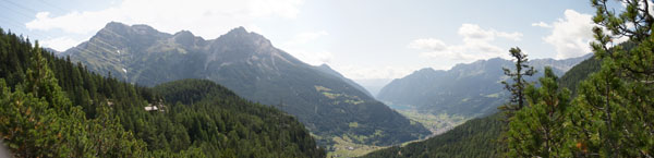
Aussichtspunkt bringt, von dem aus Du das Valposchiavo überblicken
kannst.
Weitere Informationen findest Du auf den Informationstafeln vor
Ort oder unter
www.ghiacciai.info
.
Um den Cache zu loggen, sende eine e-Mail mit den Antworten auf
die folgenden Fragen an
gc1y2z4@stmall.ch, Du
erhältst dann die Logfreigabe von mir.
1) Am Ausgang des Gletschergartens kannst Du eine kurze Treppe
unter die Brücke heruntersteigen, um einen Blick in die Schlucht zu
werfen. Dort steht eine Tafel mit einer lokalen Legende über eine
Zigeunerfamilie. Als Beweis dass Du im Gelschergarten warst, nenne
mir das letzte Wort in der linken Spalte des deutschen Texts.
2) Auf Deinem Rundgang wirst Du auf Steinhaufen stossen. Haben
diese Steine etwas mit dem damaligen Gletscher zu tun? Begründe
Deine Meinung.
Die Antworten auf diese beiden Fragen auf keinen Fall ins
Log schreiben!
Mache bitte noch ein Foto von einem der Töpfe und füge es Deinem
Log bei. Schätze den Durchmesser und die Tiefe des Topfes und
schreibe diesen in Dein Log. ACHTUNG: Bitte mach wirklich eine
Schätzung und schau nicht auf der Website der Vereinigung nach. Ich
weiss, dass dort die Zahlen stehen, aber ich möchte eine
Schätzung.
Danke an die Vereinigung Gletschergarten von Cavaglia für die
Genehmigung und Hilfe bei der Entwicklung dieses Earth Cache!
English:
«After a long period of subtropical climate, during the
Quaternary period temperature dropped by about ten degrees. Four
glacial periods, interrupted by interglacial ones, characterized
the climate of the alpine region and of many areas of the northern
hemisphere. The last glaciation, known as «Wurm», shaped the
existing pre-glacial relief of the Poschiavo valley and gave it a
new morphology. The glaciers flowing down from the southern slopes
of the Alps reached the edges of the Po valley and formed, amongst
others, the Garda, Iseo, Como, Maggiore and Lugano lakes.
Following a change in climatic conditions these glaciers then
started to retreat towards the higher regions of the alpine chain.
This retreat took place in successive stages, characterized by
positive and negative oscillations. The period was studied by C.
Burga for the Poschiavo Valley and by L. Huysmans for the Val di
Campo.
During the phase denominated Valtellina II, the Poschiavo glacier
was about 1’200 meters deep, as documented by a moraine situated at
2’230 meters. For the Val di Campo L. Huysmans found, in the Buril
area, eight morainic valleys corresponding to the same number of
retreat phases.
Important for Cavaglia is the deposit of the «Egesen» stage, which
goes back to 11’000 years before our time. At that time the
perennial snow level was about 300 m below the present one.
Starting in the «Egesen» stage the climate became warmer and
glaciers retreated to the higher regions of the Alps. It is assumed
that during the so called «Atlantic» stage vegetation returned to
the highest regions of the alpine chain.
About 4’000 years ago the climate became more rigid and glaciers
once again started to flow downwards. To date sixteen positive
oscillations can be counted starting from the «Finiglaciale». In
1850 glaciers reached their greatest expansion after the «Egesen»
stage. The Cambrena glacier reached Lago Bianco, the Palü glacier
covered the Alpe Palü basin and the edge of the Morteratsch glacier
was very close to the present railway station. It should be noted
that during the period 1965-1985 the Cambrena and Palü glaciers
advanced whilst the Corno di Campo one was always in retreat. The
Vedreit da Dügürail, which in the Fifties had a surface covered by
beautiful crevasses, has today almost disappeared».
(Aldo Godenzi on www.ghiacciai.info)
Today there are left only remaining’s from that glaciers, which
are also melting more and more away. Interesting data to that can
be found at the Earthcache »Glacier Morteratsch / Morteratsch
Gletscher«
(
GC1H7EQ) from Bobi Bohne.
What are left are the landscapes formed from the ice streams and
also the pots of the giants like it in the vernacular were called,
the glacier pots.
These holes in the rock, created by the glaciers, are no longer
visible today in many places, since they were again filled up in
the course of the years by erosion material and the
vegetation.
Here in Cavaglia the pots of the giants were opened again first by
a scout group, later helped apprentices of the RhB (raethian
railway), and finally an association was created, which worries
about the glacier pots. New pots will be opened, there were made
routes to visit the already opened pots, and the pots were
regularly emptied from rain water, since they are water tight.
Today you can visit the glacier garden in Cavaglia during the
summer months.
There is no entry charge but it is possible to leave a
contribution in the boxes placed at the Garden’s entrance and exit.
The contributions will help to continue the work in the
garden.
The glacier garden can be reached in a 10 Minutes walk from the
train station Cavaglia. I recommend coming by train, or combining
your visit with a hike on the different hiking routes. It’s
possible to reach the garden by car, and there is a parking at the
coordinates, but you have to drive narrow streets, that’s why I
don’t recommend to come by car.
The glacier pots developed through (melting-)water, which drifted
through a crevasse to the bottom of the glacier. At the bottom the
water reached a speed of up to 200 km/h and was under high
pressure. At certain point there developed rotations. There the in
sand and grit which was carried in the water eroded the ground and
»milled« like that the holes in the ground.
Begin your visit at the entry which is located at the above
mentioned coordinates. Follow the marked way, which leads you also
to a viewpoint with a spectacular view over the Valposchiavo.
Further informations can be found on the information panels at the
garden or on
www.ghiacciai.info.
For logging the cache, send an email with the answers to the
following questions to
gc1y2z4@stmall.ch, you will
receive the approval to log from me after that.
1) At the exit of the glacier garden you can descend a little
stair to have a look to the canyon from under the bridge. There is
also a panel containing a local legend about a Gipsy family
(unfortunately at the moment only in Italian and German). As a
proof of visit in the garden, give me the last word of left column
of the German text. (the German text is the one on the right)
2) On your tour through the garden you will find several piles of
stones. Have this stones something to do with the former glacier?
Give reasons for your answer.
Do not write the answers in your log!
Please take a photo of one of the pots and add it to your log.
Estimate the diameter and deepness of that pod and write it to the
log. ATTENTION: Please do really estimate it and do not look on the
association’s website. I know that the dates are on it, but I want
you to estimate.
Thanks to the Cavaglia Glacier Garden Association for the
authorization and help to develop this earth cache!