CLOOS-FALTE BEI ALTENBURG (AHRTAL) EarthCache
CLOOS-FALTE BEI ALTENBURG (AHRTAL)
-
Difficulty:
-

-
Terrain:
-

Size:  (other)
Please note Use of geocaching.com services is subject to the terms and conditions
in our disclaimer.
English version see below
Direkt an der B257 in Altenburg an der Bushaltestelle „Kreuzberger Straße“
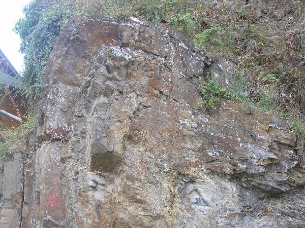
Direkt an der Bundesstraße befindet sich eines der bemerkenswertesten geologischen Naturdenkmäler Europas, die sogenannte Cloos-Falte, die nach Hans Cloos, Professor für Geologie in Bonn von 1926 bis 1951 benannt ist (und wohl in vielen Lehrbüchern der Geologie zu finden ist). Cloos’ Leistung bestand nicht nur im genauen Vermessen und Zeichnen geologischer Aufschlüsse, sondern auch darin, von den leicht zugänglichen Aufschlüssen Rückschlüsse über die Tektonik des ganzen Gebirgszuges zu treffen.
Geologie:
Vor etwa 400 Mill. Jahren (Unterdevon) befand sich der Kontinent „Laurussia“, der Nordeuropa bis zum Ural und auch Teile Nordamerikas umfasste, nördlich einer gedachten Linie Düsseldorf – Aachen. Laurussia befand sich zu diesem Zeitpunkt beiderseits des Äquators, so dass hier ein tropisches bzw. subtropisches Klima herrschte. Dadurch kam es in den Gebirgen zu intensiver Verwitterung und Abtragung. Das erodierte Material (hauptsächlich Sand, Schluff und Ton) wurde über Flüsse nach Süden abtransportiert, wo es ein riesiges Deltasystem aufbaute, welches am Rhein ungefähr bis Andernach reichte und dort ins Urmeer überging. Dieses Delta besaß eine reliefarme Plattform mit vielen mäandrierenden Flussarmen und ausgedehnten Tümpeln. Sedimentmaterial wurde weiter nach Süden ins Meer transportiert. Die Mündungsarme des Deltas reichten weit ins Flachmeer hinaus.
Durch Überflutungen des Deltas (durch tropische Starkregen vom Festland oder Überschwemmungen von der See aufgrund von Meeresspiegelschwankungen) wurden immer neue –verschiedene- Sedimentschichten aufgetragen, begünstigt durch eine zeitgleiche Absenkung des ganzen Gebietes. Im Laufe der Jahrmillionen erreichte die Schicht z.B. bei Bonn eine Dicke von ca. 3km.
Vor etwa 325 Millionen Jahren kollidierte weiter im Süden der Kontinent „Gondwana“ mit dem Kontinent „Laurussia“ (sie verschmolzen bis zum Perm zu dem Riesenkontinent „Pangaea“). Dadurch wurde der wie oben beschrieben entstandene geschichtete „Boden“ (Rheinischer Trog) auf ca. 50-60% seiner ursprünglichen Breite eingeengt, was zu einer Auffaltung durch Quetschung der vorher horizontal abgelagerten Schichten führte. Dadurch erhob sich nun auch ein Gebirgskörper aus dem Meer heraus.
Die Cloose-Falte ist eine spezielle Faltung innerhalb eines großen von Südwest nach Nordost verlaufenden Ahrtalsattels.
Bitte beachten:
Der Aufschluß steht unter strengen Naturschutz, d.h. Steine rauspopeln oder Hämmern ist untersagt.
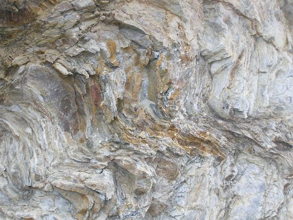 Bild2
Bild2
Um diesen Cache als Found loggen zu dürfen, musst du
a) die S-förmige Spezialfaltung (siehe Bild 2) suchen (zwischen Vorfahrt-Achten-Schild und Stromverteilerkasten). Kontaktiere mich dann via geocaching und teile mir mit, wie groß der Ausschnitt von Bild2 in natura ist.
b) ein Foto von dir vor der großen Falte in deinem Log hochladen (wieder erlaubt von GC seit Juni 2019). Dabei darfst dich ruhig ein bisschen der Falte anpassen…,
c) Ein Modell zur Faltenbildung bauen und ein Foto davon hochladen. Hier ist Kreativität, Phantasie und Originalität gefragt.
Bitte erst nach gesendeter e-mail loggen und die das Fotos sofort hochladen. Logs ohne die erforderlichen zwei Bedingungen werden kommentarlos gelöscht. Jedes Team, welches Loggen möchte, muss aus "verwaltungstechnischen Gründen" eine eigene e-mail schreiben. Loggen kannst du dann direkt nachdem du die Mail an uns versendet hast ohne eine Antwort abzuwarten.
English version: Cloos-Fold in Altenburg
Directly at the B257 in Altenburg at the bus station „Kreuzberger Straße“
Directly at the Bundesstreet is one of the remarcabelst geological monument of nature of Europe, the so called "Cloos-Falte", named after Hans Cloos, Professor for geology in Bonn from 1926 to 1951. Cloos’ effort was not only the exact meassuring and drawing of geological sites, but the drawing of conclusions about the tectonic of the whole mountain from a few simply accessable exposures.
Geology:
400 millions years ago (early Devonian) there was a continent called „Laurussia“, which contains northern Europe till Ural and some parts of North America. This continent was north of a imaginary line Düsseldorf – Aachen, and was at this time at both sides of the equator, so that the climate was (sub-)tropical. Due to that there was a intensive alteration and erosion in the mountains. The eroded material (in the main sands and clay) was transported via rivers to the south, where it built a huge delta system, which reached at the river Rhine till Andernach and passed into the sea. This delta had a relief-poor plattform with much meandering rivern and large pools. Sediments was transported far south into the sea. The eastuary mouthes want far into the flat sea. Due to floods (through heavy rains on the land or from the sea due to variations of the sea level) new and different layers of sediments were applicated, advantaged through a contemporaneus lowering of the whole area. Over the million of years the layer at Bonn for example reached a thickness of 3 kms.
325 million years ago the continent „Gondwana“ clashed in the south with the continent „Laurussia“ (they melted to the giant continent „Pangaea“). Due to that the –like above explained- developed ground (called „Rheinischer Trog“) was squeezed to 50-60% of ist original broadness, which resulted into a folding of the before horizontal layers. The mountain raised out of the sea..
The Cloose-Fold is a spezial fold in the big from southwest to northeast running Ahrtal-saddle.
The fold is listed under nature conservancy. Hammering or pulling out stones is forbidden.
To log this cache as a Found you have to
a) Upload a photo of you and the fold (re-allowed by GC since June 2019).
b) Search for the S-shaped spezial fold (see picture 2) between the give way sign and the junction box. Contact me via geocaching and tell me how big the detail on picture 2 is in natura.
c) Built a modell of the folding and add a photo of it to your log..
Logs without the two required features will be deleted.. Due to "administration" of the log-permissions it is nessecary that every team send an e-mail by itsself even if you were there together.Do not wait for log-permission, just log your found directly after sending the mail; we will contact you if there is something wrong.
Quelle: v. Koenigswald, Wighart; Simon, Klaus-Frank (Hrsg): GeoRalley Spurensuche zur Erdgeschichte, Bouvier Verlg, Bonn 2007
Additional Hints
(No hints available.)