Althea Spring is manged by the Missouri Department of
Conservation and this Earthcache has been placed by permission.
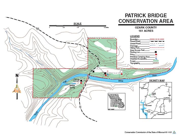
This area is mostly forest. Facilities/features here include:
picnic areas and 2 permanent streams (Althea Spring, North Fork of
the White River.) We have been down to this area on a number of
occassions to canoe and float the rivers. It is a beautiful area.
We hope you enjoy your visit.
Althea Spring, just up the hill from Patrick Bridge, is the 23rd
largest spring in Missouri. It was named for the daughter of Dr.
Paul Patrick, an early owner of land on the North Fork of the White
River. Patrick Bridge is a one-lane, low-water bridge that is on a
part of the river that is within the famous North Fork trout
fishing area. Below Bull Shoals, the White has tremendous trout
fishing along the scenic bluffs and inviting gravel bars for
picnicking or overnight camping. The trout section of the river
stretches a distance of about 90 miles.
The spring's flow is 18.80 CFS/second; an estimated 12 million
gallons per day.
Althea Spring is located in the Ozark Moutains. The region is
actually a high and deeply dissected plateau. The Ozarks consist of
four primary physiographic sections—the Springfield Plateau,
the Salem Plateau, the Saint Francois Mountains, and the Boston
Mountains. The topography is mostly gently rolling. Karst features
such as springs,losing streams, sinkholes, and caves are common in
the dolostone bedrock of the Salem Plateau. Althea spring is
located in the Salem Plateau region in Ozark County, Missouri.
A spring is any natural occurrence where water flows on to the
surface of the earth from below the surface, and is thus where the
aquifer surface meets the ground surface.
A spring may be the result of karst topography where surface
water has infiltrated the Earth's surface (recharge area), becoming
part of the area groundwater. The groundwater then travels though a
network of cracks and fissures - openings ranging from
intergranular spaces to large caves. The water eventually emerges
from below the surface, in the form of a spring.
The forcing of the spring to the surface can be the result of a
confined aquifer in which the recharge area of the spring water
table rests at a higher elevation than that of the outlet. Spring
water forced to the surface by elevated sources are artesian wells.
This is possible even if the outlet is in the form of a 300-foot
deep cave. In this case the cave is used like a hose by the higher
elevated recharge area of groundwater to exit through the lower
elevation opening.
Nonartesian springs may simply flow from a higher elevation
through the earth to a lower elevation and exit in the form of a
spring, using the ground like a drainage pipe.
Still other springs are the result of pressure from an
underground source in the earth, in the form of volcanic activity.
The result can be water at elevated temperature as a hot
spring.
The action of the groundwater continually dissolves permeable
bedrock such as limestone and dolmite creating vast cave
systems.
Types of spring outlets:
Seepage or filtration spring. The term seep refers to springs
with small flow rates in which the source water has filtered into
permeable earth.
Fracture springs, discharge from faults, joints, or fissures in
the earth, in which springs have followed a natural course of voids
or weaknesses in the bedrock.
Tubular springs are essentially water dissolved and create
underground channels, basically cave systems.
Logging requirements:Email the answers to these questions to
me:
1. What type of spring and outlet do you think Althea Spring
is?
2. At the posted coordinates you will find a sign, who owned the
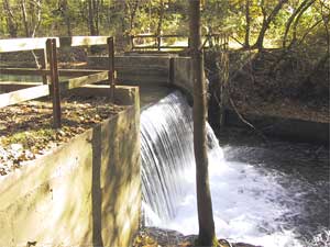
land from 1958 to 1977?
3. Go to N 36 38.540 W 092 13.682 and take a picture of yourself
with the remains of the dam. Post this picture with your log.
Congratulations to Peter and Gloria on the FTF from Canada!