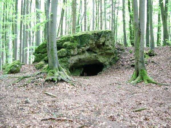
Die Jungfernhöhle ist unter anderem ein neolithischer Kultplatz der Bandkeramiker und liegt im Hofbauernholz zwischen den Dörfern Tiefenellern, Herzogenreuth und Laibarös im Landkreis Bamberg unweit des westlichen Abbruchs der nördlichen Frankenalb und ist nach Westen geöffnet.
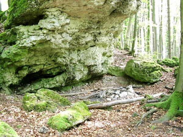
Die Höhle ist nur 9 m breit, 3 m hoch und 7 m lang. Damit handelt es sich um eine sehr kleine Höhle mit einem nur 3,50 m breiten und 1,25 m hohen Portal. Sie gehört zum Typ der Karsthöhlen. Der einzige Raum ist unregelmäßig geformt mit einigen kleineren Seitenspalten. Ausgrabungen erbrachten die Belege der Nutzung der Höhle durch vier jungsteinzeitliche und beinahe alle nachfolgenden Kulturen. Der Name Jungfernhöhle rührt daher, dass sich bei Ausgrabungen überwiegend die Überreste von weiblichen Personen fanden. Zudem ist der Name an eine lokale Sage von den drei Jungfern angelehnt. Diese drei Jungfern sollen einst in der Höhle gewohnt haben. Sie hatten keine Köpfe und wurden nach der Sage in der Höhle umgebracht.
Karst
Unter Karst versteht man in der Geologie und Geomorphologie unterirdische und oberirdische Geländeformen in Karbonatgesteinen (zum Teil auch in Sulfat- und Salzgesteinen), die vorwiegend durch Lösungs- und Kohlensäureverwitterung sowie Ausfällung von biogenen Kalksteinen und ähnlichen Sedimenten mit hohen Gehalten an Calciumcarbonat (CaCO3) entstanden sind. Hauptmerkmal ist der überwiegend unterirdische Wasserhaushalt, der nicht auf einer primären Porosität des Gesteins beruht, sondern vielmehr sekundär durch den in geologischer Zeit stattfindenden Prozess der Verkarstung (=Korrosion) bedingt wird.
Dadurch sind Landschaften, die überwiegend von Karbonaten aufgebaut werden, als Karstlandschaften ausgebildet. Großräumig finden sich diese um das Mittelmeer, sowie in Südostasien und Südchina, der Großen Antillen und im Indoaustralischen Archipel. Von in globalem Vergleich geringerem Ausmaß sind Karstlandschaften der deutschen Mittelgebirge (Schwäbische Alb, Fränkische Alb), des Schweizer Juras sowie allgemein Westeuropas und der Nord- wie Südalpen.
Humangeographisch unterscheidet sich insbesondere die Naturraumnutzung von Karstlandschaften des Mediterrans und Südost- und Ostasiens. Ist Herdenviehhaltung und eine saisonal angepaßte halbnomadische Herdentierwanderung im Mittelmeerraum in den Karstgebrigen seit der Antike verbreitet, so findet in tropischen Karstländern durch eine differenziertere agroökonomische Wirtschaftsform mit Kleintierhaltung und Bewässerungsfeldbau kulturtopologisch eine diametral gegensätzliche Naturraumnutzung statt. Die Nutzung von Karsthochflächen tritt somit außerhalb des Mediterrans kaum auf, daher ist insbesondere in der Kulturregion des Mittelmeeres auch eine stärkere Degradierung von Karsthochländen und Entwaldung mit anschließender Schädigung der Bodendecke für die dortige Problematik des Karstes verantwortlich.
Beantwortet die folgenden Fragen:
1. Die kleine Höhle liegt unweit des XXX Albabbruchs?
2. Dieser Kultplatz liegt nur wenige hundert Meter von einer ausgedehnten YYYY Siedlung entfernt?
3. Handelt es sich bei dieser Höhle um eine unterirdische oder oberirdische Karsthöhle?
4. Was stellt die untere Zeichnung auf der Infotafel dar?
5. Schaut Euch in der näheren Umgebung ein wenig um. Wieviele weitere Karstgebilde könnt Ihr in unmittelbarer Nähe der Jungfernhöhle noch sehen?
Schickt mir Eure Antworten an kermangc@gmail.com. Sofern sie nicht in Ordnung sein sollten, werde ich mich melden. Geloggt werden kann sofort.
Ich freue mich über ein Bild von Euch oder Eurem GPS-Gerät wie im Beispielfoto vor der Höhle.
Die größte Bitte, die ich habe ist: bleibt auf den Wegen bzw. Pfaden, damit ihr diesen schönen Wald nicht unnütz beschädigt. Es gibt drei mögliche Parkplätze. Einer, bei dem man mit ca. 1,5 km Fußmarsch rechnen muss P1, der andere ist ein ganz kleiner unauffälliger, bei dem man ca. die Hälfte der Strecke laufen muss, welcher aber maximal 3 Autos P2 zulässt und sehr eng ist, auch die Einfahrt ist schnell zu übersehen. Die beste Parkmöglichkeit bietet P3.
Viel Spaß wünschen euch KerMan
< ;
;
English Version
Among the rest, the spinster cave is a neolithischer cult place of the Bandkeramiker and lies in the court farmer's wood between the villages Tiefenellern, Herzogenreuth and Laibarös in the administrative district Bamberg not far from the western demolition the northern franc nightmare and is opened to the west.
The cave is only 9 m wide, 3 m high and 7 m long. With it it concerns a very small cave with an only 3.50 m wide and 1.25-m-high main entrance. It belongs to the type of the two-pronged mattock caves. The only space is formed irregularly with some smaller side columns. Excavations produced the documents of the use of the cave by four neolithic and nearly all following cultures. Hence, the name Spinster cave stirs that with excavations predominantly the remains of female people were found. Besides, the name is leant against a local legend of three spinsters. Once these three spinsters should have lived in the cave. They had no heads and were killed after the legend in the cave.
Two-pronged mattock
One understands by two-pronged mattock in the geology and geomorphology subterranean and surface area forms in carbonate rocks (partly also in the sulphate and salt rocks) which have originated mainly from solution and carbonic acid decomposition as well as Ausfällung of biogenic limestones and similar sediments with high contents of Calciumcarbonat (CaCO3). Charasteristic feature is the predominantly subterranean water household which not is based on a primary Porosität of the rock, but is caused rather secondarily by the process taking place in geologic time of the karst formation (=Korrosion).
The sceneries which are built up predominantly by carbonate are thereby trained as karstlands. Extensively these are found around the Mediterranean Sea, as well as in South-East Asia and South China, the Greater Antilles and in the Indoaustralischen archipelago. From magnitude lower in global comparison are karstlands of the German low mountain ranges (Swabian nightmare, Frankish nightmare), the Swiss law as well as in general Western Europe and the north like south nightmares.
Human-geographically in particular the open space use differs from karstlands of the Mediterrans and South-East Asia and Eastern Asia. If cooker cattle position and a seasonally conformist half-nomadic gregarious animal wandering is spread around the Mediterranean in the Karstgebrigen since the antiquity, a diametrically contradicting open space use takes place in tropical two-pronged mattock countries by a more differentiated agroeconomic economic system with keeping small domestic animals and irrigation field construction cultural-topological. The use of two-pronged mattock high surfaces hardly appears therefore beyond the Mediterrans, hence, a stronger degradation of Karsthochländen and deforestation with next damage of the ground cover is responsible in particular in the cultural region of the Mediterranean Sea also for the problems there of the two-pronged mattock.
Answers the following questions:
1. The small cave lies not far from XXX nightmare demolitions?
2. This cult place lies only in few hundred metres from a vast settlement YYYY?
3. If it concerns with this cave a subterranean or surface two-pronged mattock cave?
4. What shows the lower drawing on the info board?
5. Looks around to You in the closer surroundings a little. How many other two-pronged mattock things you can still see in immediate nearness of the spinster cave?
Badge sends your answers us please by Send message and waits for the log release.
After occurred log release we are glad about a picture of You or your GPS device like in the example photo before the cave.
The biggest request which we have is: remains on the ways or paths, so that you damage this nice wood not pointlessly. There are three possible parking bays. One with which one must calculate on approx. 1.5 km of walk P1 the other is smaller more unobtrusive quite with which one must run approx. half of the distance which admits, however, maximum 3 cars P2 and is very narrow, also the entrance is quick overlooking. The best possibility is P3.
A lot of fun wish you KerMan
< ;
;
Quelle: Wikipedia PS: zum Beantworten der Fragen ist ein Betreten der Höhle nicht nötig. Es könnte unter Umständen sein, dass sich dort Fledermäuse aufhalten, die einem besonderen Schutz jährlich vom 01.10-30.04. bedürfen. 19.10.2019: autoresponder entfernt