Geologisches Phänomen am Petersberg
Keuper-Aufschluss
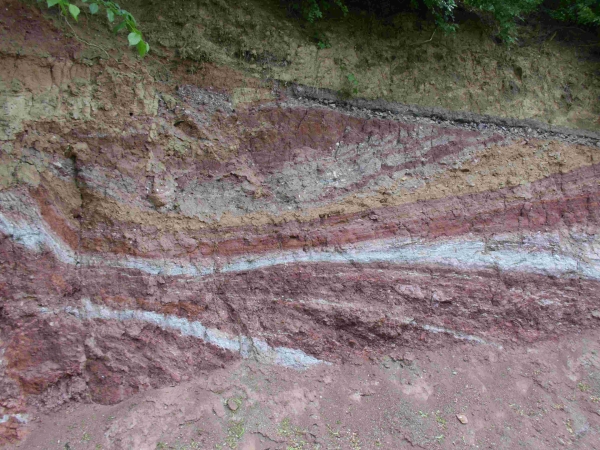
Der Keuper ist die oberste der drei lithostratigraphischen Gruppen der Germanischen Trias. Diese Dreiteilung, die namensgebend für das chronostratigraphische System Trias war, gilt aber nur für den Bereich nördlich der Alpen (Germanische Trias-Supergruppe). Der Keuper wird in etwa auf den Zeitraum von 235 bis 199,6 Millionen Jahre datiert. Er folgt auf die lithostratigraphische Gruppe des Muschelkalks und wird von der lithostratigraphischen Gruppe des Lias (Norddeutschland) bzw. des Schwarzen Jura (Süddeutschland) überlagert.
Die Untergrenze des Keuper wird in Norddeutschland mit der Unterkante des sog. Unteren Lettenkohlensandsteins definiert. In Süddeutschland ist die Untergrenze die Basis des „Grenzbonebeds“. Die Obergrenze ist die Basis des Lias in Norddeutschland bzw. des Schwarzen Jura in Süddeutschland. Die Typregion ist Franken. Im Norddeutschen Becken werden durchschnittliche Mächtigkeiten zwischen 300 und 500 Metern erreicht, lokal bis 1000 Metern. Im Glückstadt-Graben lassen seismische Untersuchungen auf eine Mächtigkeit bis 5000 Meter schließen. Es handelt sich um marin beeinflusste Kalk- und Tonsteine, lakustrine Kalk- und Tonsteine, fluviatile und litorale Sand- und Siltsteine, fossile Böden und Wurzelhorizonte und mächtige Salinarfolgen, wobei im Beckenzentrum in Norddeutschland Steinsalz, in den randlicheren Bereichen Anhydrit und Gips abgelagert wurden.
[Quelle: Wikipedia]
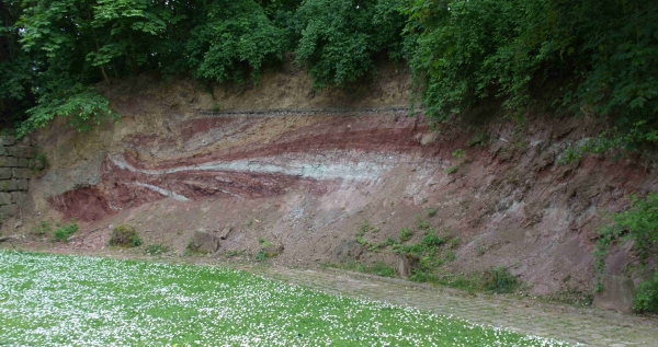
Der Petersberg befindet sich im Westen der Stadt. Er gehört zusammen mit dem benachbartem Domberg zu der "Erfurter Störungszone". Er tritt mit einer Höhe von ca. 230m morphologisch hevor und gehört zu der Hügelgruppe Haarberg – Großer und Kleiner Herrenberg – Stadtpark – Domberg - Petersberg – Kleiner Roter Berg bei Gispersleben.
Der Petersberg ist ein Ausläufer der ca. 300 m hohen Ebene von Gotha kommend und ab Bindersleben Flughafen auslaufend in Richtung Petersberg mit einem Sattel zum Domberg. Dieser Ausläufer fällt südlich steil bis zum Bergstrom und im Osten zur Andreasstrasse und Domplatz ab.
Im Norden läuft der Petersberg flach in Richtung Klinikum ab. Der Hangabschnitt unterhalb der Bastion Philipp zeigt den ursprünglichen geologischen Aufbau des Petersberges.
(vgl. www.petersberggeschichte.info)

[Quelle: www.thueringer-naturbrief.de]
Um diesen Earthcache loggen zu dürfen,
beantwortet bitte folgende Fragen:
Die Infotafel wurde vor Jahren mutwillig zerstört. Mittlerweile wurde eine neue Tafel aufgestellt. Um loggen zu dürfen beantwortet folgende Fragen.
1. Vor wievielen Jahren wurde der Keuper aus dem "Gemanischen Becken" abgelagert? (A=?)
2. Wie weit erstreckt sich die Störungszone von Bad Berka bis nach Dachwig? (B=?)
3. Nenne Punkt C von der Legende. (C=?)
4. Schätzt die Höhe und Breite des Auschlusses. (D=?)
5. Mach bitte ein Foto von dir und deinem GPS vor dem Keuper-Aufschluss und ladet dies bei eurem Log mit hoch. Dies ist keine Logbedingung.
Schreibt eine E-Mail mit eurem Nicknamen im Betreff an:
ronnsteff.geocaching@gmail.com
Ihr dürft sofort loggen. Wenn etwas nicht stimmen sollte, melden wir uns.
VIEL SPAß WÜNSCHT EUCH
Ronnsteff & Wahooka
English Version
Background information on the Petersberg Citadel
The Citadel Petersberg (also Peter Fortress Mountain) was originally a kurmainzischen, later Prussian fortress city of the 17th to the 19th century, located in the center of the Thuringian capital of Erfurt.
It is considered one of the largest and best preserved of its kind in Europe and was built in 1665 by order of the kurmainzischen Elector and Archbishop Johann Philipp von Schönborn as fortress against the city in neuitalienischen style. Later on they should protect the electorate as the most northern fortress from attacks by the Protestant powers. The strategic importance of the Citadel realized later the French and the Prussians, they start the 19th Century for a short time occupied. With the Congress of Vienna in 1815 she came to Erfurt to the Prussian Kingdom and was used until German unification in 1871 as a fortification. She remained well during the two world wars and the war a key military site in the region.
From 1963 the site was partially accessible to the public. From 1990 the state of Thuringia and the city of Erfurt renovations to a greater extent by. Nowadays there are the buildings of the fortress state offices, homes and tourist and cultural facilities.
[Source: Wikipedia]
Geological phenomenon at the Petersberg
Keuper digestion
The Keuper is the highest of the three lithostratigraphic groups of the Germanic Triassic. This division, which was eponymous for the chronostratigraphic system Trias, but only for the area north of the Alps (Germanic Triassic Super Group). The Keuper is roughly the period dated from 235 to 199.6 million years. He follows in the lithostratigraphic group of the mussel and the lithostratigraphy of the Lias Group (Northern Germany) and the Black Law (southern Germany) is superimposed.
The lower limit of the Keuper is defined in northern Germany with the bottom edge of the so called lower carbon Latvians sandstone. In southern Germany, the lower limit to the base of the Grenzbonebeds is. The upper limit is the base of the Lias in northern Germany and the Black Jura in southern Germany. The type region is francs. In the North German Basin average thicknesses 300-500 meters can be achieved locally up to 1000 meters. In happiness city moat seismic studies suggest a thickness of up to 5000 meters. It is marine influenced limestone and mudstones, lacustrine limestone and mudstones, fluvial and coastal sand and siltstone, fossil soils and root horizons and powerful Salinarfolgen, where in the basin center in northern Germany, rock salt, in the of marginal areas of anhydrite and gypsum were deposited.
[Source: Wikipedia]
The Petersberg is in the west of the city. He is grouped with the adjacent Cathedral Hill to the "Erfurt, fault zone". He comes with a height of about 230m morphologically hevor and belongs to the group of hills Haarberg - out Little Red Mountain near Gispersleben - Great and Little Mr. Berg - City Park - Cathedral Hill - Peter Berg.
The Petersberg is an extension of about 300 m high level of Gotha, and Coming from Bindersleben airport terminals in the direction of Peter Berg with a saddle on Cathedral Hill. This spur falls steeply to the south and east to Bergstrom Andreas Street and Cathedral Square.
Runs in the north of the Petersberg flat in the direction of the hospital. The slope, below the bastion Philipp shows the original geological structure of the Petersberg.
(compare: www.petersberggeschichte.info)
[Source: www.thueringer-naturbrief.de]
To log this Earthcache
please answer the following questions:
The information panel has been vandalized several years ago. Meanwhile, a new board was set up.
To be allowed to log in to answer the following questions . Some of this can be found on the Internet.
1. How many years ago the Keuper was deposited from the "Geman Basin"? (A=?)
2. How far extends the fault zone from Bad Berka to Dachwig? (B =?)
3. Name point C on the legend. (C=?)
4. Estimates the height an width of the Keuper. (D=?)
5. Please make a photo of you an your GPS in front of the Keuper digestion and upload it to your log. This ist not Log condition.
Please send an E-Mail with your Nickname in Subject to:
ronnsteff.geocaching@gmail.com
You can log right away. If there is something wrong, we will contact you.
WISH YOU MUCH FUN
Ronnsteff & Wahooka