EN
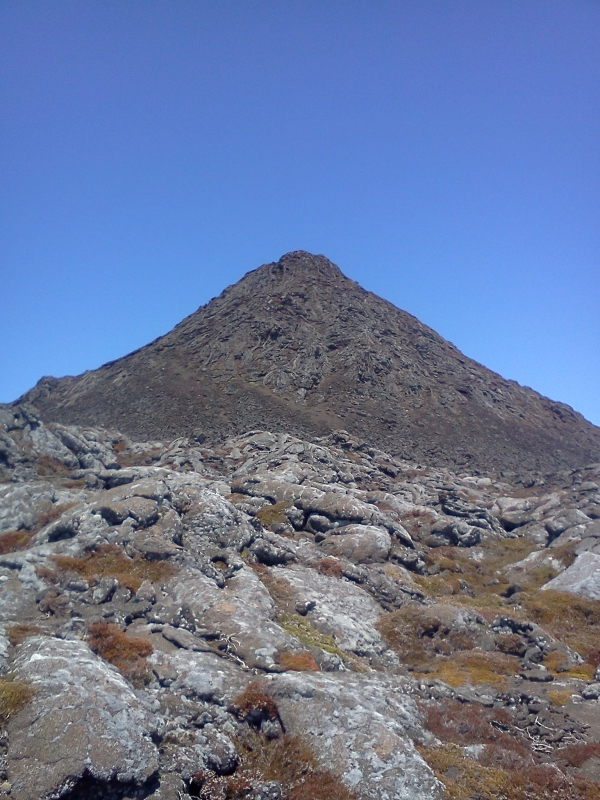
Pico mountain is the highest point on Pico Island in the Azores. It reaches an altitude of 2,351 meters above sea level, which makes it the highest point in Portugal. Pico is more than twice the elevation of any other peak in the Azores.
PT
A montanha do Pico com 2,351 mts é o ponto mais alto de Portugal. Esta montanha situa-se na ilha do Pico, no Arquipélago dos Açores e tem o dobro da altura de qualquer outra levação nos Açores.
 Pico is the result of several eruptions that started 240 000 years ago, building the mountain by stages.
Phase I - Construction of a large volcanic cone, due to a major activity in the central part of the volcano and reached dimensions similar to the current volcano. This phase ends with the collapse of the top of the volcano, creating a crater-pit with about 800m in diameter at an altitude of about 2050m.
Phase II - Volcanic activity at the top of the volcano takes place from fissures located in the crater, causing extensive lava flows , which meet throughout the crater, and increase the height of the volcano. This phase ends once again causing a collapse of the volcano crater at an elevation of approximately 2250m.
Phase III - The origin of Piquinho. A small volcanic cone emerged inside of the crater. Increasing the height to 2351m.
PT
O Pico é o resultado de diversas erupções que começaram à cerca de 240 000 milhões de anos e que foram construindo a montanha por etapas.
Fase I – Edificação de um grande cone vulcânico, devido a uma grande actividade na parte central do vulcão, tendo atingido dimensões semelhantes à do vulcão actual.Esta fase termina com o colapso do topo do vulcão, originando uma cratera-poço com cerca de 800m de diâmetro a uma altitude de cerca de 2050m.
Fase II – A actividade vulcânica no topo do vulcão dá-se a partir de fissuras localizadas na cratera, originando extensos derrames lávicos pahoehoe, que preenchem toda a cratera, e aumentam a altura do vulcão.Esta fase termina novamente num colapso do vulcão originando uma cratera à cota aproximada de 2250m.
Fase III – Formação do cone do Piquinho, no interior da cratera actual, elevando aaltura para os 2351 mts.
mais info em http://ilhapiconatural.blogspot.com
 Historical eruptions of Pico have occurred on its flanks rather than the summit crater. In 1562–64, an eruption on the southeast flank produced lava flows which reached the sea. Another flank eruption in 1718 also produced flows which reached the coast. The most recent eruption occurred in December 1720.
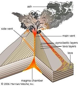
 A stratovolcano is usually tall and conical in shape and is built up by many layers (strata) of hardened lava, tephra, pumice, and volcanic ash. Unlike shield volcanoes, stratovolcanoes are characterized by a steep profile and periodic, explosive eruptions.
The lava that flows from stratovolcanoes typically cools and hardens before spreading far due to its high viscosity. Stratovolcanoes are sometimes called "composite volcanoes" because of their composite layered structure built up from sequential outpourings of eruptive materials. They are among the most common types of volcanoes. Two famous stratovolcanoes are the Vesuvius and Mount Fuji.
PT
Um Estratovulcão é habitualmente alto, com uma forma cónica, construída por várias camadas (estratos) de lava endurecida, piroclastos, pedra-pomes e cinzas vulcânicas. Ao contrário dos vulcões escudo, os estratovulcões são caracterizados pelo perfil íngremes e pelas erupções explosivas e periódicas.
A lava que flui normalmente estratovulcões arrefece e endurece antes de se espalhar muito, devido à sua alta viscosidade. Estratovulcões são às vezes chamados de "vulcões compósitos" por causa de sua estrutura composta em camadas construída a partir de desabafos sequenciais de materiais eruptivos. Eles estão entre os tipos mais comuns de vulcões.
Dois estratovulcões famosos são o Vesúvio e do Monte Fuji.
To log this Earthcache, please email me the answers:
1. How high is Piquinho?
2. How is the lava that flows from Stratovolcanoes?
3. Please name two other famous Stratovolcanoes
4. what color is the rock at Ground Zero?
5. At the Ground Zero you'll find a different shape on the rock, what looks like?
PT
Para fazer o Found desta Earthcache, por favor envie-me as seguintes respostas:
1. Qual a altura do Piquinho?
2. Como é a lava que flui de um Estratovulcão?
3. Indique o nome de outro 2 famosos Estratovulcões?
4. De que cor é a rocha no GZ?
5. No GZ vai encontrar uma forma diferente nas rochas, o que lhe parece ser?
|

Getting to the top can take 3 hours. The normal route starts from 1200 m and is always up to the summit, with 4.7 Km long, to climb safe I advice to start early morning, at 8:30 more or less. Don't forget that the time you waste to get to the top will be the time needed to get down, its 4700 meters long to descent in slow progression, so don't stay much hours in the top.
Before starting your climb you must leave your name at the Mountain Information Center and at the way back tell that you arrived safely. If you want there are a few local mountain guides. You can get their contact at the local tourism office.
Is very important the use the right equipment to climb and be prepared to fast weather changes.
PT
Chegar ao cimo do Pico pode demorar cerca de três horas, para percorrer 4,7km. O trilho normal começa aos 1200 mts, e é sempre a subir até o cume. O ideal será começar de manhã bem cedo, às 8:30. Não se esqueça que o tempo que precisou para chegar ao topo será o tempo necessário para descer, os outros 4.7km. Deverá ter em mente que esta é uma descida em progressão lenta, por isso atenção ao tempo que fica no topo.
Antes de iniciar a sua ascensão deve deixar seu nome no Centro de Informação da Montanha e no regresso deve informar que chegou bem.
Para quem preferir poderá contactar um guia de montanha, para o acompanhar na subida. Pode obter estes contactos no posto de turismo local.
É muito importante o uso de equipamento adequado para subir e estar preparado para mudanças climáticas rápidas.
Webcam | Wheather
GPX or Wikiloc
! Have Fun !
!Diverte-te!

|