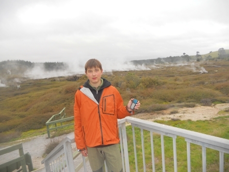
This earth-cache takes you to the Craters of the Moon, and the walk takes about an hour. You will be able to see bubbling craters, steams, colourful soils and mudpools etc... The path is well-formed.
Craters of the Moon
Craters of the Moon is a thermal area on the north of Taupo. The name was given according to many craters which arose there. In Maori language it is named Karapiti. It is a part of a geothermal field Wairakei. Geothermal field is an area of the thermal activity where you can see hot springs, mud pools, geysers and steam vent. All these things are caused by underground water which is heated by magma.
Primarily, the Craters of the Moon were created after Geothermal Power Station was opened in 1958. It began to take underground water from the Wairakei Field. This reduced the water pressure. After that water boiled more and more steam was produced. The steam needed to escape somewhere which led to the creation of the Craters of the Moon.
The area of the Craters of the Moon is 0.36 km2 and there are many thermal features: Craters, fumaroles and mudpools.
Craters
When a steam is blocked under the surface, there can be formed a new crater. How? When the blocked steam clears, the fall in the pressure causes that the underlying water boil vigorously. The boiling water arises a steam which erupts out the vent. The eruption throws the material (soil, mud, hot water, steam and pumice) to the surrounding area. Material can be thrown up to 100 meters. This form the hole or crater which can be deep 20 meters.
Fumaroles
Fumarole is an opening from which steam and volcanic gases escape to the surrounding. The size of fumaroles is from one centimetre to half a meter in diameter. You can hear some sounds which resemble whistling. It is because of steam that escapes through the tiny cracks.
Mudpools
Mudpools arise when steam reaches the surface and condense into water. Then the water reacts with gases to form sulphuric acid. This acidic liquid is turning the rock into a soft mud. The grey soft mud is that what you can see. The mud bubbles because of the gas and steam that wants to escape from the ground. The smell of ‘spoiled egg’ is given by hydrogen sulphide.
The Taupo Volcanic Zone
The Taupo Volcanic Zone where the Craters of the Moon lies is a region of active volcanoes and geothermal activity. It stretches from Tongariro National Park (Mount Ruapehu) to White Island (Whakatane volcano). It is about 250 kilometres long and 30-80 kilometres wide and covers an area of 19,635 km. This area lies on fault line of Pacific and Indo Australian Plates. This zone is one of the most active geothermal and volcanic areas in the world today and it contains almost 80% of NZ’s geothermal systems.
Attention
To complete this cache you need to go on geothermal walk in the areal of the Craters of the Moon. It is not a free walk. You must pay a fee. Some informations:
OPENING HOURS
- 8.30am - 6pm - November - 6th April (end of daylight saving)
- 8.30am - 5.30pm - During the winter months - dependant on daylight
ADMISION CHARGES
- adult - 10.00$ (April 2023 updated)
Child is between 5 - 12 years. Under 5 years are free of charge. Family = 2 adults and maximum of 4 children.
If something changes please e-mail me. Thank you for cooperation.
To complete this earth-cache you must preferably text me [or e-mail me](throught my profile) the answers on these questions. Do not post your answers online! You do not have to wait for my confimation. You can log this cache as found just after sending me the answers. If something is wrong, I will contact you by text or email.
Questions:
- Question 1: S 38° 38.656 E 176° 04.292
According to the picture on the sign: Why geysers gush? - Nowadays, the sign is missing, so find it out on the Internet or on another sign.
- Question 2: S 38° 38.842 E 176° 04.157
What is the maximum number of allowed people on the bridge?
- Question 3: S 38° 38.940 E 176° 04.080
According to the picture on the sign:
- What is the temperature of the steam from the craters?
- What is the maximum temperature in which ferns and small plants grow?
- Question 4: S 38° 38.778 E 176° 03.931
- Make a gues: How many column of steams do you see?
- Optional - Take a photo of your GPS and craters/steams in background. This photo can be taken anywhere in the areal of the Craters of the Moon, but I think this is a good spot. Please do not include answers to the questions in the photo. Post this photo with your Found It log.
There is an example how the photo for log can look like.

Happy Earth Caching
Resources for the pictures:
http://www.picacommunications.com/wordpress/?paged=3
and my own
Resources for the information:
Signs in the areal of Craters of the Moon.
http://en.wikipedia.org/wiki/Craters_of_the_Moon_%28geothermal_site%29