Meteoritnedslaget Silurringen / Getryggen EarthCache
Meteoritnedslaget Silurringen / Getryggen
-
Difficulty:
-

-
Terrain:
-
Size:  (not chosen)
Please note Use of geocaching.com services is subject to the terms and conditions
in our disclaimer.
The unique geological formation of Silurringen is a result of the
large meteorite impact and the glacial erosive forces. Here you
will find traces of this events.
To log this Earthcache as a found you have to hike the 750 meter
path around the naturreservat.
It starts at the parking area "Styggforsen".
Answer the questions which you can find at the end of the
listing.
.......................................
Den ringformade geologiska strukturen i Siljansområdet
(Silurringen) tilldrog sig tidigt stort intresse hos såväl svenska
som utländska forskare. Den redovisades på en karta över södra och
mellersta Sverge redan 1832. Strukturen har få motsvarigheter i
övriga världen både vad gäller utseende och sammansättning. Under
årens lopp har flera teorier framlagts som förklaring till ringens
ursprung. Idag vet vi med säkerhet att uppkomsten av ringen har att
göra med att jättelikt meteoritnedslag för ca 360 mio år
sedan.
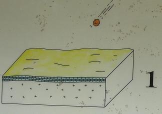
En jättemeteorit på mellan 2-3 km diameter slog ned på jordytan som
då täcktes av ett ca 400m tjockt lager av sedimentbergarter
(silurisk sandsten, kalksten och lerskiffer) på ett underlag av
främst granit.
..............................
EN:
The ring-shaped geologic structure of the Siljan area (Silurringen)
attracted the early interest in both Swedish and foreign
researchers. It was reported on a map of southern and central
Sweden already 1832. The structure has few counterparts in the rest
of the world both in appearance and composition. Over the years
several theories put forward to explain the origin of. Today we
know with certainty that the onset of the ring has to do with that
giant meteorite impact about 360 Mio years ago. A giant meteorite
of between 2-3 kilometers in diameter struck the Earth at that time
was covered by an approximately 400 meter thick layer of
sedimentary rocks (Silurian sandstone, limestone and shale) on a
backing of mainly granite.
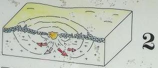
Nedslaget gav upphov till en krater som var 30-40km i diameter och
5 km djup.
De branta kratersidorna var så instabila att bergmaterialet gled
ned i kratern.
.............................
EN:
The impact produced a crater that was 30-40km in diameter and 5km
deep.
The steep crater sides were so unstable that rock material slid
down the crater.
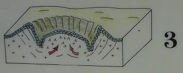
Den mer eller mindre lodräta ställningen av de sedimentära
berglager som förekommer i ringen torde ha uppkommit i denna fas av
kraterns utveckling. De centrala delarna av kraterbottnen höjdes
därefter tämligen omgående som ett resultat av jordskorpans strävan
att utjämna de uppkomna mäktighetsskillnaderna. Höjningen kan ses
som en sorts rekylrörelse.
...............................
EN:
The more or less vertical position of the sedimentary rock layers
that occur in the ring would have been incurred in this phase of
crater development. The central parts of the crater bottom was
raised. Then almost immediately to smooth the thickness differences
of the crustal.. The increase can be seen as a sort of recoil
motion.
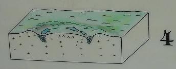
Under de 360 mio år som förflutit sedan meteoritnedslaget
inträffade har nedbrytande krafter åstadkommit stora förändringar
av landskapets topografi. Man räknar med att ca 1 km av bergrunden
nötts bort. Praktiskt taget hela den ursprungliga meteoritkratern
har utplånats. Tack vare att de sedimentära bergarterna sjönk ned i
jordskorpan har rester av dessa bevarats fram till våra
dagar.
..............................
EN:
During the 360 mio years since meteorite impact occurred, the
destructive forces brought about major changes the landscape's
topography. It is estimated that approximately 1 km of bedrock
eroded. Virtually all the original meteorite crater has been
obliterated. Thanks to the sedimentary rock sank into the earth's
crust have residues of these conserved present day.
Silurringen
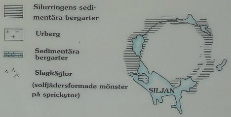
Geologisk Karta
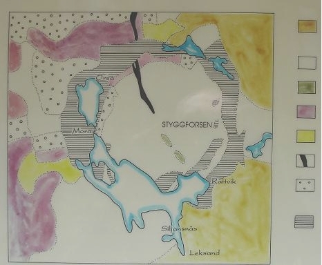
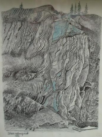
Getryggen
Den höga klippan med sina brant uppresta, tunnskiktade berglager
kallas "Getryggen", ett namn som ofta används på både bergsryggar
och rullstensåsar med spetsig form.
..............................
EN:
The high cliff, with its steep upright, thin-layered rocks called
"Getryggen", a name often used on both ridges and ridges with a
pointed shape.
..............................
Figure out all answers near the rock formations that you can find
at the coordinates.
To log this cache as a found you have to email me via
geocaching.com the answers of the following questions:
A) Find out which material Getryggen is made of and
B) how old it is.
These bedrocks sedimented originally horizontal, but the great
upheaval by meteorite impact led to 360 million years ago tipped
them over until its now almost vertical position.
C) Estimate the hight of Getryggen (stand near the
coordinates).
D) Take a closer look at the deep grooves. Estimate the angle in
which they lie.
A) Ta reda på vilket material Getryggen består av och
B) hur gammal den är.
Lagren sedimenterade ursprungligen horisontellt, men den stora
omvälvning av berggrunden som meteoritnedslaget medförde för 360
miljoner år sedan stjälpte dem över ända till det nu nästan lodräta
läget.
C) Uppskatta höjden på Getryggen (stå vid koordinaterna).
D) Ta en ordentlig titt på de djupa fårorna. Uppskatta i vilken
vinkel de står.
Please dont wait for my permission! If there was something wrong, I
will contact you!
Sorry! I had to delete logs without answer emails.
One last thing:
Please upload a photo that shows you or your GPS or only the
landscape in this area. It reminds me of MY beautiful holiday
there! Thank you! 
I hope you enjoy this Earthcache and the beautiful area!
Have fun!
Ant Z
Additional Hints
(No hints available.)