Shrinking of Lake Nipissing
Type of Land:
Wisconsin State Forest - State Park sticker required.
Terrain:
This is an easy 3/4 mile hike with small, gentle hills through a wooded area to get to the site.
Description of Area:
Parking is located either in a small lot just past the check-in station or across Cty O from the entrance road.
- This section of the trail is open 365 days per year.
- Hunting is allowed on the property so caution should be taken during hunting seasons.
- Pets are allowed on a leash.
Suggested Equipment and Supplies:
GPS Unit
Method of measuring the width of the features(ridge & swale).
GPS Coordinates:
Trailhead on Office Entrance Road N 44 12.690 W087 30.713
EarthCache Site N 44 12.138 W087 30.812
Educational Information:
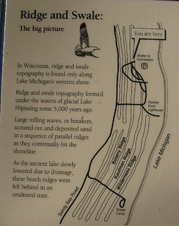
As the glacial ice receded to the north, an immense volume of melt water filled the Lake Michigan basin to form post-glacial lakes. The elevation and extent of these lakes were dependent on the elevation of the lowest outlet available during that period. A high water level phase occurred 4000-6000 years ago when Lakes Michigan, Huron, and Superior were considered to be one large lake referred to as glacial Lake Nipissing.
Down-cutting of the northern outlet and crustal rebound continued after the weight of 1-2 miles of glacial ice left. As the lake levels fell from the Nipissing high water phase over several thousand years to the present, several sand and gravel shorelines were created. Large rolling waves, or breakers, scoured out and deposited sand in a sequence of parallel ridges as the ancient lake slowly lowered due to drainage. The shoreline was pushed lake-ward by sedimentation, but the process proceeded in fits and starts as indicated by the ridge-swale pairs. The ridges are where a beach was when the lake level was stable for a while as the lake level lowered after the glacial retreat. The swales are the low, wet areas between these old beach ridges. The swales contain thick peat (partially decayed plant material) deposits up to five (5) feet deep. Point Beach has a series of about 30 parallel ridges with narrow swampy swales.
The wetland swales provide frogs, salamanders, and mosquitoes with protected places to lay their eggs. The ridges contain a variety of trees, including beech, hemlock, and white pine.
In order to log this EarthCache as a find the following tasks must be completed:
- There will be a bench at the site coordinates. Is the bench on a ridge or by a swale?
- What direction is feature running?
- How wide is the nearest ridge? How wide is the nearest swale?
Please email the answers to me via my profile on the cache page.
The Geocache Notification Form has been submitted to Don McKinnon. Geocaches placed on Wisconsin Department of Natural Resource managed lands require permission by means of a notification form.
Please print out a paper copy of the notification form, fill in all required information, then submit it to the land manager. The DNR Notification form and land manager information can be obtained at: http://www.wi-geocaching.com/modules.php?name=Wiki&pagename=Hiding%20A%20Cache
 IATCC is the cache designation to highlight a series of EarthCaches along the Ice Age National Scenic Trail grouped into a special category called "ColdCache."
The Ice Age Trail is one of eleven National Scenic Trails designated by the National Park Service. This unique trail is entirely within the state of Wisconsin and follows along the terminal moraine of the most recent glacier which retreated about 10,000 years ago.
This project is supported by the Ice Age Trail Alliance (IATA). The goal is to bring more visitors to the trail and promote public awareness, appreciation, and understanding of Wisconsin’s glacial landscape.
The IATA has created an awards program to encourage visits to the trail and ColdCache sites. This awards program is separate from, and in addition to, any other Geo- or EarthCache awards program.
A current list of approved ColdCache sites can be found on the “IATCC Bookmark List”. More information on the Ice Age Trail Atlas, the Companion Guide, the ColdCache Project and Awards Program can be found on the “ColdCache Webpage”