|
 Português Português
Morfologias Graníticas da Serra da Gardunha
Um colosso de granito ergue-se abruptamente sobre o vasto plano de Castelo Branco, atingindo os 1227 metros na sua altitude. Rodeada de um anel de pinhal até aos 800 metros, os seus cumes despidos lembram castelos arruinados. São frequentes estas acumulações de morfologias graníticas, blocos graníticos moldados pela circulação de água subterrânea, respeitando o sistema de fracturas que lhes dão origem, conhecidas por Caos de Blocos.
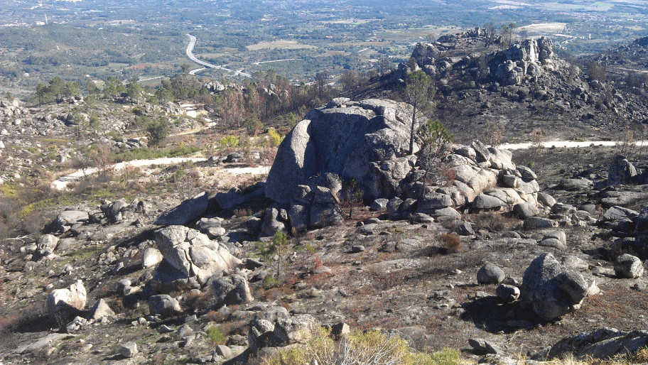
Estamos num local onde podemos avistar diversos afloramentos graníticos, em plena Serra da Gardunha, dignos de uma lição acerca do tema descrito nesta EarthCache.
Blocos e Caos de Blocos
Os blocos ou bolas consistem em penedos de dimensões variadas, de tamanho métrico, no geral arredondados, assentes na superfície topográfica, e que se encontram por vezes em grande quantidade formando aglomerações designadas por Caos de Blocos. Estas formas apresentam uma grande dispersão geográfica, observando-se em todos os climas.
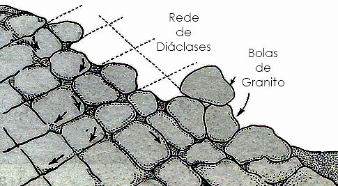 São características de rochas granitóides, embora se desenvolvam também noutras rochas granulares, como os arenitos e mesmo os basaltos. A génese das bolas implica a presença de uma rocha de textura granular recortada por uma rede de diaclases espaçadas, aproximadamente ortogonais, uma vez que elas se formam geralmente a partir de blocos limitados pelas diaclases. Assim, embora os blocos sejam característicos dos granitos, geram-se preferencialmente em granitos de grão grosseiro, onde as fracturas tendem a apresentar maior espaçamento, fracturados por diaclases ortogonais. Tal como sucede com os outros elementos morfológicos de meteorização, os blocos correspondem a resíduos de alteração existindo dois processos para a sua génese: São características de rochas granitóides, embora se desenvolvam também noutras rochas granulares, como os arenitos e mesmo os basaltos. A génese das bolas implica a presença de uma rocha de textura granular recortada por uma rede de diaclases espaçadas, aproximadamente ortogonais, uma vez que elas se formam geralmente a partir de blocos limitados pelas diaclases. Assim, embora os blocos sejam característicos dos granitos, geram-se preferencialmente em granitos de grão grosseiro, onde as fracturas tendem a apresentar maior espaçamento, fracturados por diaclases ortogonais. Tal como sucede com os outros elementos morfológicos de meteorização, os blocos correspondem a resíduos de alteração existindo dois processos para a sua génese:
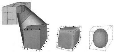 - génese subaérea, por progressão da erosão subaérea a partir de cada diaclase e nos ângulos entre as diaclases; estas alargam-se e os ângulos arredondam-se progressivamente originando bolas muito regulares, segundo uma transição progressiva de paralelepípedo a esfera; - génese subaérea, por progressão da erosão subaérea a partir de cada diaclase e nos ângulos entre as diaclases; estas alargam-se e os ângulos arredondam-se progressivamente originando bolas muito regulares, segundo uma transição progressiva de paralelepípedo a esfera;
- génese subterrânea, em que as bolas se desenvolvem "potencialmente" em profundidade, permanecendo envolvidas pela areia de alteração do granito (ou de outra rocha granular), até que a erosão subaérea remova essa areia.
Note-se que um maior ou menor número destes blocos se deslocam posteriormente sobre a superfície topográfica por acção da gravidade, descendo a partir do afloramento onde se geraram e imobilizando-se geralmente a pouca distância deste.
Para validar e registar esta EarthCache, terão de me enviar as respostas às seguintes questões:
Uma das formas de identificar e diferenciar os diferentes tipos de granito é através da sua textura e também pela presença de minerais característicos.
1. Identifica o tipo de textura do granito junto às coordenadas publicadas. Indica também dois minerais que compõem o granito.
2. O que são diaclases?
3. Nas coordenadas publicadas, no cimo do miradouro, indica qual a altitude que o teu GPS marca.
4. Nas coordenadas publicadas, no cimo do miradouro, podemos observar argolas espetadas na rocha, cuja finalidade é servir de suporte para desportos tipo escalada ou outras variantes. Indica o que esta escrito nessas argolas.
5. No local, com a ajuda de uma bússola, virado para Oés-Noroeste, indica quantas antenas consegues visualizar.
Se acreditas ter obtido toda a informação necessária para concluir esta EarthCache, conforme solicitado, sente-te à vontade para a registar. Posteriormente iremos verificar as respostas enviadas e se necessário for, iremos entrar em contacto contigo.
Pedimos para não publicarem fotos que possam dar resposta às questões colocadas.
DESDE JÁ AGRADEÇEMOS A VISITA À NOSSA EARTHCACHE. ESPERAMOS QUE TENHAM GOSTADO DO TEMA AQUI DESCRITO E PARA ALÉM DISSO, APRECIEM A MAGNIFICA PAISAGEM!
|