To get to the spectacular An Steall (The Spout) waterfall requires you to walk the rocky path through the Steall Gorge, a place described by W H Murray as "the best half mile in Scotland". The Water of Nevis certainly has carved out a gorge of Himalayan grandeur and the whole area is looked after by The John Muir Trust, the leading wild land conservation charity in the UK. Their noticeboard at the car park at the end of the road from Fort William tells people how not to spoil wild landscapes and this earthcache involves no collecting, box placing or destruction 
This is meant to be a fun and educational earthcache but it will possibly be beyond some cachers for it involves crossing a wire bridge and wading through a shallow river. The bridge has warning notices on it to say that it can be dangerous to use and that no more than 2 people should be on it at one time. 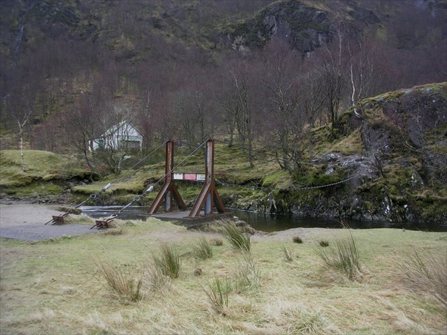
If you are not up to crossing this, there are the 2 traditional caches on the north bank of the river that you could try and find instead.
The Local Geology:
The 1344 metres of Ben Nevis are the remains of a spectacular volcano and a chamber of magma beneath it which erupted about 420 million years ago, when 2 continents collided and the Caledonian Mountains were raised. Although the summit on 'The Ben' is made of lava, on the valley sides most of this has been eroded away leaving granite walls.
About the same time as Ben Nevis was erupting, another mass of granite magma pushed into the earth's crust to the south forming the reddish summits of the western Mamore mountains. The lower slopes of the hills are of much older rocks. They originated as mud and sand on the edge of a shallow sea about 800 million years ago.
When the continents collided they were deeply buried, heated and squeezed, forming metamorphic rocks. The muddy rocks turned into schist, with bright flakes of mica often visible, while the sandstones turned into hard white quartzite. You can see examples of all these rocks types as you walk through the Gorge of Steall.
Around 20,000 years ago most of Scotland was covered by an ice sheet more than 1km thick.
Just 12,000 years ago a glacier filled this valley and carved out the 'U' shaped valley of Glen Nevis. There is evidence for the glaciers all around including rocks at Polldubh Crags and at the side of the path which are smooth and streamlined in one side and steep on the other. The streamlined side indicates the direction the glacier was travelling from and, as it passed over the rock, it plucked at the training edge leaving the steep side. The Gorge of Steall is of more recent origin and has been carved by running, stone-carrying water.
To log the earthcache you need to message the answers to the following questions and (optionally) post a photograph of yourself at the site. You can log your visit as a "find" for your  straight away and I will contact you asap to let you know any errors if there are any.
1) On the path to the waterfall are many rocks with wavy ridges on them. 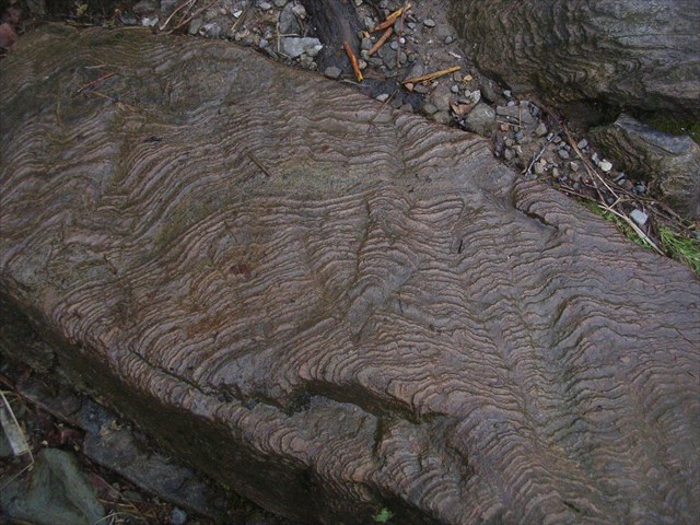 Look closely and you may be able to see crystals in these. Describe the shape of these crystals and suggest how they came to be like this. From the description above (& any noticeboards you might spot in the Fort William region) say what type of rock they are.
2) What is the name given to the rocks and boulders which are streamlined in one side and steep on the other. Can you tell me which direction (N, S, E, W or inbetween) the glacier that smoothed them appears to have been flowing?(
3) When you get to Steall Meadows, where shepherds still lived in the 1940's, you will see the wire bridge - a single strand plus 2 hand rails, about 15 feet above the fast flowing Water of Nevis. Cross this and get to the listing co-ordinates at the foot of the waterfall. Most of the boulders here are grey but there are some large rocks of a different colour. These were originally sedimentary rocks made of sand (i.e.quartz) particles. Look and see if you can see any particles or crystals in them now? Tell me what sort of rock you think these are and what happened to the crystals?
If you like you could take a photo of yourself near the obvious tree with the waterfall behind you and post it with your log or if you have a friend with you they might be able to take one of you on the wire bridge.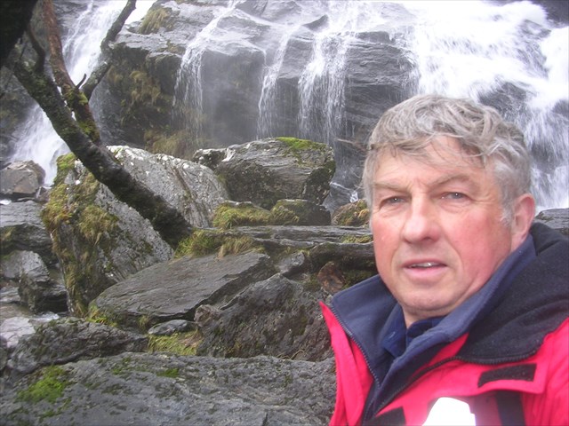
4) Now to accurately estimate the width and the height of the waterfall!
Move carefully to the right hand side of the fall and mark the position with your gps. Now cross to the other side of the waterfall and see how far away you are from your previously marked position. This is the maximum width of the An Steall.
NB. The rocks at the foot of the falls are very slippy and, unless there is very little water coming down the waterfall, it will almost certainly be safer and easier to cross the water lower down. At N56 46.301 W004 58.872 there are gravel beaches and shallows which one can wade through fairly easily, especially if you have good gaiters and a walking pole, unless the river is REALLY in spate.
You are almost bound to have taken at least one photo showing the full size of the fall. Now that you know the width at the base, you should be able to accurately say how many times higher the waterfall is than wide.
All you then need to do is e mail are the co-ordinates of the left and right sides of the falls, plus what your gps suggests the width to be, then your estimate of the height.