Hill City Fold EarthCache
-
Difficulty:
-

-
Terrain:
-

Size:  (not chosen)
Please note Use of geocaching.com services is subject to the terms and conditions
in our disclaimer.
The Goal:
In this EarthCache, you'll visit a fantastic example of a geological fold and learn a bit about how folded rocks are characterized.
SAFETY FIRST:
This EarthCache is a roadcut along U.S. Highway 16/385. While there is plenty of room to pull over and see the rocks, be careful of the potential dangers from rocks falling from above and of vehicles on the road. Exercise caution when parking your vehicle and when walking along or across the road.
Everyone knows rocks don't bend, they break, right?
Wrong! Rocks are just like lots of other materials - under the right conditions of stress, they can fold instead of fracture. Sedimentary and volcanic rocks such as sandstones, lava flows, limestones, ash layers, and mudstones are all deposited as flat, horizontal layers when they are formed. Later, stresses in the Earth due to tectonic plate motions sometimes cause these rocks to become folded. In the image below, a few layers are bent into simple folds.

Notice that these folds have a vertical plane going down the middle of them, which is called the axial surface. If the folded layer bends downward, the fold is called a syncline. If the folded layer bends upward, the fold is called an anticline. But in both of these cases, the axial surface is vertical, straight up & down. These two folds are both therefore called upright folds.
Now suppose that the axial surface of a fold wasn't upright, but was rather at an angle.
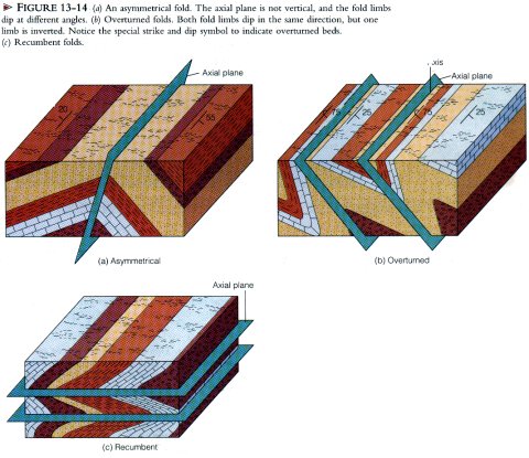
In the above image, examples B shows the axial surface at an angle. In this case, geologists say that the fold is inclined. Another case is shown in example C, where the axial surface is horizontal. These kinds of folds are called recumbent folds.
To log this EarthCache:
To claim this EarthCache, visit the location and send me an email with an answer the following questions:
1) Is this fold a syncline, an anticline, an inclined fold, or a recumbent fold? To answer this question, visit the location given by the coordinates, which should take you to a grassy area on the side of the highway. Turn and look across the road, at the cut of rock on the other side that exposes the rocks. You'll see a very large fold! Use your powers of observation to determine what kind it is.
2) Estimate of the length of the fold that is visible in the roadcut. Provide your answer in feet or meters. The easiest way to do this is to carefully mark a point in your GPSr at one end of the fold, then tell your GPSr to GOTO that point, then walk to the other end of the fold and read the distance to the point on your GPSr.
NOTE: No photos are required to log this EarthCache. Please do not post any answers to the questions in your log or post any photographs of the roadcut that give away the answers to the questions.
Additional Hints
(No hints available.)