Pilgrim River along the great fault
Cache Summary: Many river valleys are strongly influenced by faults, the Pilgrim River is located along the great Keweenaw fault. Visitors will park in the Nara Parking Lot. From here it is a short walk along a paved trail. Visitors will need to cross highway M41 as the river flows on the opposite side of the parking lot ( N 47° 6.085’ W 88° 31.029’). There is not a cleared path so do not be afraid to walk through the vegetation to see a better view! This cache is part of the MiTEP program in Houghton, check out some of our other caches!
Fig 1. A glimpse of the Pilgrim River. Photo: J. Finta
Cache Coordinates: N 47° 6.085’ W 88° 31.029’
EarthCache Lesson: Why does the Pilgrim River run down this fault?
A fault is simply a crack in the Earth’s surface caused by a movement in the Earth’s surface. Not every crack at Earth’s surface represents a fault. The key to observing a fault is that rocks become shifted as they move on either side of this “crack”. The rock movements along these cracks provide geologic clues of past plate tectonics and plate boundaries; puzzle pieces that make up the surface of the Earth’s crust.
The Keweenaw Fault is traceable through the Keweenaw Peninsula passing just east of the cities of Houghton- Hancock (see figure 2).
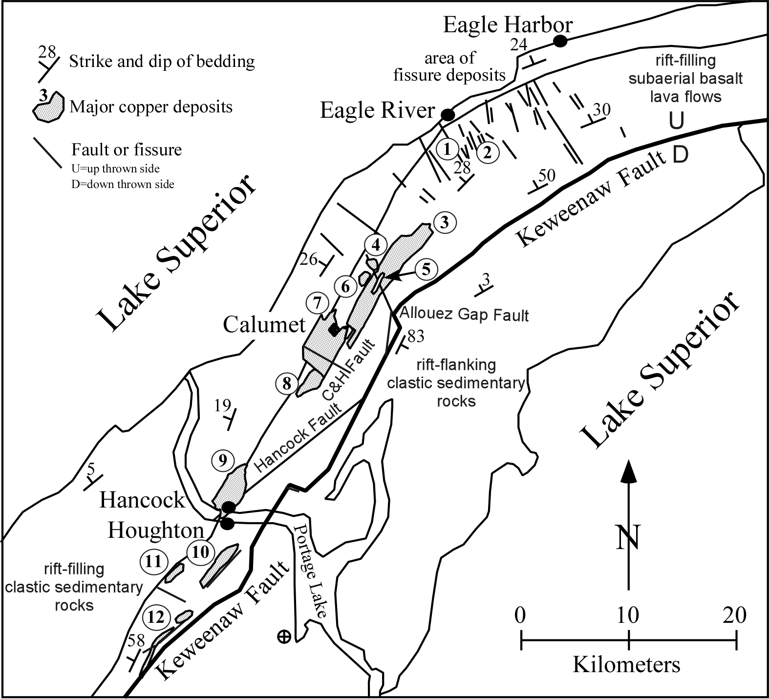
Figure 2. A map of the Keweenaw Fault’s location within the Keweenaw Peninsula. Source: Graphic by Theodore Bornhorst found at http://michigannature.wordpress.com/2010/07/15/the-secret-behind-the-copper-country%E2%80%99s-native-deposits/
The Keweenaw Fault formed when a tectonic plate collided with the North America somewhere to the southeast, thus causing one side of the fault to be pushed upward, or uplifted, higher than the other side.. This is apparent by observing the two main types of rocks on either side of the fault. On the northwestern side of the Keweenaw Fault the older Basalts from the Portage Lake Volcanic were uplifted and exposed during the collision. The younger Jacobsville Sandstone are still present on the southeast side of the fault.
Sandstone is a sedimentary rock made of layers upon layers of sediments that have deposited onto top of one another. This layering makes sedimentary rocks easy to identify. Sandstone comes in a variety of textures and earthy colors but the Jacobsville Sandstones of this area are reddish. It is porous (large spaces between rock particles) and is easily eroded because it is much softer than the other rock present.
Basalt on the other hand is an igneous rock that is formed from volcanic lava flows that have cooled quickly. Due to the quick cooling at Earth’s surface these rocks have little time to form crystals. Basalt is considered fine grained therefore much more impervious (small spaces between rock particles), making it both denser and harder than sedimentary rocks. Basalt is much darker in color than Sandstone, often black / dark gray in color.
Fig 3 Diagram showing the relation of basalt and sandstone. Source: http://www.geo.mtu.edu/~raman/SilverI/HoughtonEC/Pilgrim_Kew_Fault.html
Rivers follow a path that is easiest to flow, or the path of least resistance. The Pilgrim River we would expect to follow the Keweenaw Fault but upon observation it flows to the South/Southeast of the Keweenaw Fault.
Fig4. Simplified Geologic map of Pilgrim Watershed showing the . Source: http://www.geo.mtu.edu/~raman/SilverI/HoughtonEC/Pilgrim_Kew_Fault.html
Logging your visit:
To obtain credit for visiting this EarthCache, please email me the responses to the following questions.
Logging Question 1:
Though glaciers have left layers of gravel, gravel and other glacial deposits, the bedrock can be seen in various locations. Take a moment to observe the rocks at the bridge, along the walking path, and along the rivers edge, make detailed observations about the type of rock outcrops you see and if you can identify which rocks are present- basalt or sandstone?
Logging Question 2:
After close observation of the rocks present, which type of rock is the river flowing through? Provide reasoning based on the evidence you see.
Earth Science Literary Principals Big Ideas
#3.6 Earths systems are dynamic; they continually react to changing influences. Components of Earth’s systems may appear stable, change slowly over long periods of time, or change abruptly with significant consequences for living organisms.
As the plates have formed faults they have left evidence of geological changes along these boundaries allowing one to observe to changes over time. The Pilgrim River also provides evidence of how the landscape has changed over time in its presence.
Common Earth Science Misconceptions:
All bed-rock is solid, non-porous material.
In this EarthCache visitors will observe two different rock types, sedimentary Sandstone and igneous Basalt. After observation vistors will understand that not all bedrock is solid, which is evident by the erosion of the Sandstone as water flows over the rock.
References:
U.S. General Services Administration,. (2/24/12). Historic Preservation-Technical Procedures Retrieved from. http://www.gsa.gov/portal/content/112582. Last accessed 16th July 2012
Mike Strickler (April 1st 1997). Ask GeoMan, What are the most important types of rock in the crust?. Retrieved from http://jersey.uoregon.edu/~mstrick/AskGeoMan/geoQuerry27.html. Last accessed 16th July 2012
Rose, Bill. (2012) Earth Science Institute. Available:
http://www.geo.mtu.edu/~raman/SilverI/HoughtonEC/Pilgrim_Kew_Fault_files/PilgrimRWatershedGeo.pdf. Last accessed 16th July 2012
Rose, Bill. (2012) Earth Science Institute. Available: http://www.geo.mtu.edu/~raman/SilverI/HoughtonEC/Pilgrim_Kew_Fault_files/PilgrimRWatershedGeo.pdf. Last accessed 16th July 2012