Church Micro 2372... West Kingsdown- St Edmund EarthCache
Church Micro 2372... West Kingsdown- St Edmund
-
Difficulty:
-

-
Terrain:
-

Size:  (not chosen)
Please note Use of geocaching.com services is subject to the terms and conditions
in our disclaimer.
This cache is both a Church Micro and an Earthcache. The above coordinates will take you to the South west wall of the Church where you will need to find the answers to some questions about the Church, and further research answers about the Northdowns, Chalk and Flint.
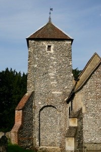
The church is a Grade 1 listed building known locally as “the church in the woods”. It is set in woodland to the west of Fawkham Road, approximately 500 yards from its junction with London Road in the hilltop village of West Kingsdown in Kent.
Most historians suggest that the oldest part of the church was built around 1030 AD - before the Norman Conquest in 1066 and thirty years before the construction of Rochester Cathedral - but the first known record occurs in the Textus Roffensis, a schedule of buildings within the Diocese of Rochester made in 1120.
Some authorities indicate that the Church probably began its life as a private chapel built by the Saxon Lord of the Manor. It is also considered possible that it was once surrounded by a small Saxon village - wooden dwellings long disappeared. Kingsdown became a Parish in 1265 and the list of Rectors, to be seen on the North wall of the Church, dates from that time.
The tower occupies an unusual position in that it is at the South East corner of the Nave instead of the more usual North side. Built of native material from the North Downs the absence of quoin stones is held to indicate its great antiquity
Perhaps the greatest of the Church’s treasures is the little Norman window on the South wall. The glass is modern because the opening was not discovered until 1908 when workmen were removing some of the external rendering. Beyond the rounded arch the bricklayers discovered the splayed reveals and the medieval paintings we see preserved today.
This window decoration was dated as 1110 by Dr C R Dodwell, who was then the Librarian at Lambeth Palace and an authority on 12th century art. The artist depicts the story of Cain and Abel. The sacrifice is shown on the Eastern splay while the murder is on the West.
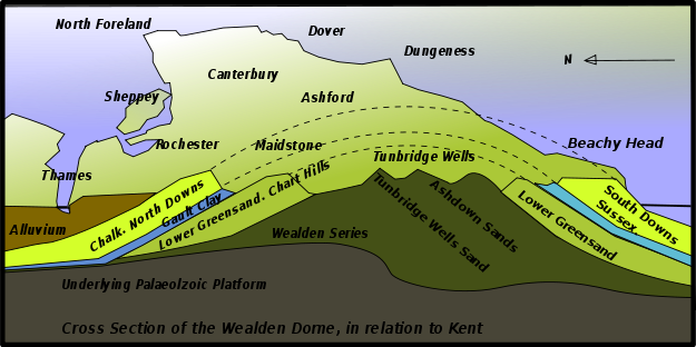
So to the Earthcache: The Church is less than a mile away from the edge of the Northdowns. The Northdowns are a ridge of Chalk confined chiefly to the counties of Surrey and Kent and the south to Sussex.
Chalk is a soft, white, porous sedimentary rock, a form of limestone composed of the mineral calcite. Calcite is calcium carbonate or CaCO3. It forms under reasonably deep marine conditions from the gradual accumulation of minute calcite plates (coccoliths) shed from micro-organisms called coccolithophores. It is common to find chert or flint nodules embedded in chalk. Chalk can also refer to other compounds including magnesium silicate and calcium sulphate.
Chalk has greater resistance to weathering and slumping than the clays with which it is usually associated, thus forming tall steep cliffs where chalk ridges meet the sea. Chalk hills, known as chalk downland, usually form where bands of chalk reach the surface at an angle, so forming a scarp slope. Because chalk is porous it can hold a large volume of ground water, providing a natural reservoir that releases water slowly through dry seasons.
Flint is categorized as a variety of chert. It occurs chiefly as nodules and masses in sedimentary rocks, such as chalks and limestones. Inside the nodule, flint is usually dark grey, black, green, white, or brown in colour, and often has a glassy or waxy appearance. A thin layer on the outside of the nodules is usually different in colour, typically white and rough in texture. From a petrological point of view, "flint" refers specifically to the form of chert which occurs in chalk or marly limestone. Similarly, "common chert" (sometimes referred to simply as "chert") occurs in limestone.
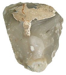
The exact mode of formation of flint is not yet clear but it is thought that it occurs as a result of chemical changes in compressed sedimentary rock formations, during the process of diagenesis. One hypothesis is that a gelatinous material fills cavities in the sediment, such as holes bored by crustaceans or molluscs and that this becomes silicified. This theory certainly explains the complex shapes of flint nodules that are found. The source of dissolved silica in the porous media could arise from the spicules of silicious sponges. Certain types of flint, such as that from the south coast of England, contain trapped fossilised marine flora. Pieces of coral and vegetation have been found preserved like amber inside the flint. Thin slices of the stone often reveal this effect.
As a building material: Flint, knapped or unknapped, has been used since antiquity (for example at the Late Roman fort of Burgh Castle in Norfolk) up to the present day as a material for building stone walls, using lime mortar, and often combined with other available stone or brick rubble. It was most common in parts of southern England, where no good building stone was available locally, and brick-making not widespread until the later Middle Ages. It is especially associated with East Anglia, but also used in chalky areas stretching through Hampshire, Sussex, Surrey and Kent to Somerset. Flint was used in the construction of many churches, houses, and other buildings, for example the large stronghold of Framlingham Castle. Many different decorative effects have been achieved by using different types of knapping or arrangement and combinations with stone (flushwork), especially in the 15th and early 16th centuries.
To Claim this earthcache you must answer the following questions:
1. Flint is found in Chalk. It is a hard sedimentary cryptocrystalline form of which mineral?
2. What prehistoric period were the North Downs formed in?
3. At the above coordinates stand and observe the SW wall of the Church. The Church is mainly constructed from Flint. Name two other building materials used.
4. Also at the above coordinates look to the left of the light above the door. There is a large piece of flint. Estimate the length of this flint. Also describe what a flint looks like on the outside and on the inside.
5. Now take an Elevation reading here (at the listed coordinates).
6. Now travel to N51 18.555 E000 22.400 (motorway bridge over the M20). Take an elevation reading here and work out the Elevation difference between here and the innitial coordinates of the Church. Knowing what you have read above and other reseacrch explain why the two elevation readings are different.
Optional: Take a picture of yourself or GPS next to a flint.
Please e-mail me your answers. If you log your claim without sending me your answers your log will be deleted.
If any body would like to add to this series, please do, but could you please let sadexploration know first, so he can keep track of the Church numbers and names to avoid duplication.
Additional Hints
(No hints available.)