Camí Natural de la Muga.
Us proposem conèixer millor l’Alt Empordà amb la ruta que trobareu paral·lela al riu Muga: El camí Natural de la Muga.
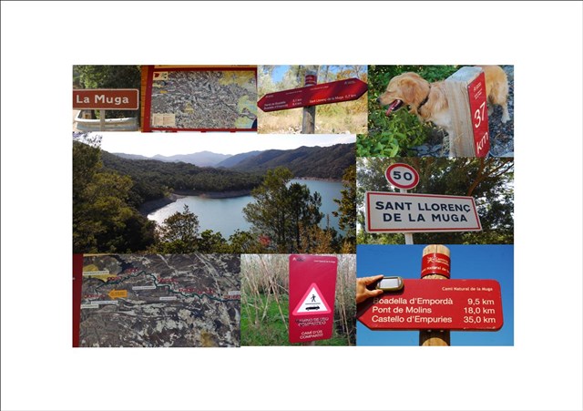
L’inici d’aquesta ruta és al poble de Sant Llorenç de la Muga i acaba a Empuria-Brava, tot i així per no “coincidir” amb un altre ruta proposada per un company també a la zona, el darrer amagatall el trobareu a les portes del poble de Castelló d’Empúries.
La ruta té una distancia aproximada d’uns 40km, ideal per fer en BTT o a peu en diferents etapes. Alguns trams són de circul·lació compartida i es pot fer amb vehicle, preferentment, 4X4.
La distància que trobareu entre els amagatalls pot variar entre un o dos kilòmetres.
La mida dels contenidors és micro.
No penjo el track de la ruta, en trobareu molts a la xarxa, des de la plana de Salines-Bassegoda, wikiloc i d’altres planes.
Com és normal, us demanem que sigueu curosos amb els “muggles” i deixeu els contenidors ben amagadets...
Trobareu un link per descarregar el llibre de ruta, com que les coordenades sempre varien una mica segons el dispositiu GPS, utilitzeu les fotos espòiler, hem intentat posar amagatalls fàcils de descobrir.
NOTA: EN EL MOMENT DE LA PUBLICACIÓ DE LA RUTA I DEGUT AL TRÀGIC INCENDI OCORREGUT A L’EMPORDÀ EL JULIOL DEL 2012, EL TRAM BOADELLA - PONT DE MOLINS ESTÀ TALLAT A TOTA MENA DE CIRCULACIÓ, L’ACCÉS ALS CATXÉS QUE ES TROBEN EN AQUEST TRAM ÉS SOTA LA VOSTRA RESPONSABILITAT. GRÀCIES PER LA VOSTRA COMPRENSIÓ.
Moltes gràcies i a gaudir de la ruta.
Camí Natural de la Muga.
We propose you to know better the Alt Empordà with the route that you will find parallel to the river Muga: El Camí Natural de la Muga.
The beginning of this route is in the village of Sant Llorenç de la Muga and ends at Empuria-brava, though for not to coincide with another route proposed by a partner of the zone, you can find the last hiding place at the gates of the village of Castelló d’Empúries.
The route has a distance of approximately 40 km, ideal for BTT or walking in different stages. Some sections are of shared traffic and can be done by vehicle, preferably 4x4.
The distance between one cache and other one can vary between one to two kilometers.
The size of the container is micro.
I do not hang the track of the route, since you can find many pages in internet, for example: the Salines-Bassegoda’s page, wikiloc and many others.
As usual, we ask you to be careful with the “muggles” and let the container well hidden...
You'll find a link to download the roadmap since the coordinates always change a little bit according to your GPS device, use the photos spoiler, we have tried to find easy hiding places
ATENTION: IN THE MOMENT OF THE PUBLICATION OF THE ROUTE AND DUE TO THE TRAGIC FIRE HAPPENED IN L'EMPORDÀ IN JULY’2012, THE SECTION BOADELLA - PONT DE MOLINS IS CUT TO ALL KINDS OF TRAFFIC. THE ACCESS TO THE CACHES WHO ARE IN THIS SECTION IS UNDER YOUR OWN RESPONSIBILITY. THANK YOU FOR YOUR COMPREHENSION.
Thank you very much and enjoy the route
Link llibre de ruta / The whole way
https://www.dropbox.com/s/g8xliagn3wbyeo5/CAM%C3%8D%20NATURAL%20DE%20LA%20MUGA.pdf