Mt. Pateras - Tower of Milos Traditional Geocache
Mt. Pateras - Tower of Milos
-
Difficulty:
-

-
Terrain:
-

Size:  (small)
Please note Use of geocaching.com services is subject to the terms and conditions
in our disclaimer.
ENGLISH
The cache is a part of a series of caches placed at Mountain Pateras in order to reveal its forgotten beauty.
Overview of mountain Pateras
The Mountain Patera is located in the northwestern edge of the Attica prefecture, with its highest peak, Leontari, at 1,132m.
Almost all the slopes are steep and inaccessible.
A large part of the Mountain Patera was full of pines and oaks, while over the 800 m it had firs that were burned in the fire of 1985. Today, after almost 30 years, the pinewood has started to regenerate.
On the peaks there are pines, Shina, arbutus and firs. The east and south side of the Mountain Patera is designated as game shelter with a rich fauna of foxes, hares, hawks, eagles, partridges, etc.
The Mountain Patera has also a great archaeological interest. In the foothills there are many archaeological sites and over 20 ancient towers-outposts scattered across the mountain that protected the ancient town Megarida, from prospective hackers. The ancient paths of Mountain Patera were used since antiquity for the communication of nearby villages and today offer many interesting opportunities for hiking.
THE CACHE
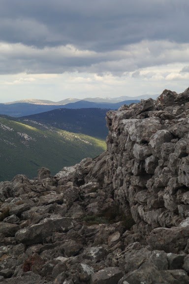
Tower of Milos (1120 meters altitude)
The tower - guardhouse of Milos is located above the ancient Ereneia.
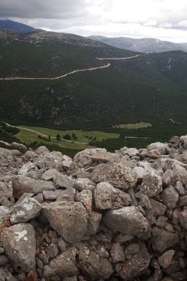
The Tower of Milos is circular (of diameter 7 meters) and is located in a position with great view. In antiquity it supervised the paths to the ancient Megarida. The tower was protected by a stone precinct of 140m which is still preserved.
The time required reaching tower - guardhouse of Milos depends on which point you start hiking - mountaineering.
The trails are steep and rocky in many places. You will need proper shoes, water and food.
The cache is a small cylindrical plastic container, initially containing a log book, a pencil, a geocaching declaration in Greek and in English and some small items for exchange
PLEASE!!! Replace the log book and the cache as found for their protection, due to the bad weather conditions in the area. Tighten the cover!
Recommended routes:
- From Mikro Krifti (N38 05.734 E23 18.803) with the easiest ascent of Mountain Pateras to the col of Milos. The trail is wide and portions preserved from antiquity. The distance is 2,5 kilometers and approximate time 1.5 hours (without the return) The downside is that you need 4x4 vehicle to reach the Mikro Krifti. The route from the Veniza village to Mikro Krifti is 6 kilometers and is needed 2 hours by foot. The route from Megara to Mikro Krifti is complicated because of the many forest dirt roads.
- Alternatively from the routes listed in the cache of the "Douskia peak" (http://coord.info/GC45Q0B)
- Some Routes from wikiloc
http://el.wikiloc.com/wikiloc/view.do?id=2742675
http://el.wikiloc.com/wikiloc/view.do?id=1509538
ΕΛΛΗΝΙΚΑ
Η κρύπτη είναι ένα μέρος από μια σειρά κρυπτών που τοποθετήθηκαν στο όρος Πατέρα, έτσι ώστε να αναδείξουν την ξεχασμένη ομορφιά του.
Γενικά για το Όρος Πατέρα
Το όρος Πατέρας βρίσκεται στο βορειοδυτικό άκρο του νομού Αττικής, με ψηλότερη κορυφή το Λεοντάρι στα 1.132 μ.
Όλες σχεδόν οι πλαγιές του είναι απότομες και δύσβατες . Ένα μεγάλο μέρος του Πατέρα ήταν κατάφυτο από πεύκα και πουρνάρια, ενώ από τα 800 μ. και πάνω είχε έλατα, που κάηκαν στην πυρκαγιά του 1985. Σήμερα, μετά από σχεδόν 30 χρόνια, το πευκοδάσος έχει αρχίσει να αναγεννάται. Στις ψηλές κορυφές υπάρχουν πεύκα, σχίνα, κουμαριές και έλατα. Η ανατολική και νοτιοανατολική πλευρά του Πατέρα είναι χαρακτηρισμένη ως καταφύγιο θηραμάτων με πλούσια πανίδα από αλεπούδες, λαγούς, γεράκια, αετούς, πετροπέρδικες κ.α.
Επίσης το όρος Πατέρας παρουσιάζει και αρχαιολογικό ενδιαφέρων . Στους πρόποδές του υπάρχουν αρκετοί αρχαιολογικοί χώροι καθώς και πάνω από 20 αρχαίοι πύργοι-φυλάκια διάσπαρτοι σε όλο το βουνό τα οποία προστάτευαν την αρχαία Μεγαρίδα από επίδοξους εισβολείς.
Τα αρχαία μονοπάτια του Πατέρα που χρησιμοποιούνταν από την αρχαιότητα για την επικοινωνία των γύρω οικισμών προσφέρουν και σήμερα ευκαιρίες για πολλές ενδιαφέρουσες πεζοπορικές διαδρομές.
Η ΚΡΥΠΤΗ
Πύργος Μύλου (898 μέτρα υψόμετρο)
Ο πύργος – φυλάκιο Μύλου βρίσκεται πάνω από την αρχαία Ερένεια.
Ο πύργος του Μύλου είναι κυκλικός (διαμέτρου 7 μέτρων) και βρίσκεται σε θέση με μεγάλη θέα. Κατά την αρχαιότητα επόπτευε τα μονοπάτια προς την αρχαία Μεγαρίδα. Ο πύργος προστατευόταν με πέτρινο περίβολο 140μ ο οποίος σώζεται έως σήμερα.
Ο χρόνος που θα χρειαστείτε για να φτάσετε στο πύργο-φυλάκιο Μύλου εξαρτάται από ποιό σημείο θα ξεκινήσετε την πεζοπορεία – ορειβασία.
Η διαδρομές είναι ανηφορικές και πετρώδεις σε πολλά σημεία. Θα χρειαστείτε κατάλληλα παπούτσια, νερό και τροφή.
Η κρύπτη είναι ένας μικρός κυλινδρικός σωλήνας που αρχικά περιέχει logbook , geocaching decalration στα ελληνικά και στα Αγγλικά και μερικά μικρά αντικείμενα για ανταλλαγή.
ΠΑΡΑΚΑΛΩ!!! επανατοποθετήστε το log book και την cache όπως τα βρήκατε για την προστασία τους, λόγω των δύσκολων καιρικών συνθηκών που επικρατούν στο σημείο. Βιδώστε σωστά το καπάκι !!!
Προτεινόμενες πορείες
- Από τον Μικρό Κρύφτη (N38 05.734 E23 18.803) με την πιο εύκολη ανάβαση του όρους Πατέρα προς το διάσελο του Μύλου . Το μονοπάτι είναι φαρδύ και τμήματά του σώζονται από την αρχαιότητα. Απόσταση 2,5χιλιόμετρα και χρόνος περίπου 1,5 ώρα (χωρίς την επιστροφή).
Το μειονέκτημα είναι ότι χρειάζεστε όχημα 4Χ4 για να φτάσετε στο Μικρό Κρύφτη. Η διαδρομή 6χιλιομέτρων από τον οικισμό Βένιζα μέχρι το Μικρό Κρύφτη χρειάζεται 2 ώρες αν αποφασίσετε να την κάνετε με τα πόδια. Η διαδρομή από τα Μέγαρα προς τον μικρό Κρύφτη είναι περίπλοκη λόγω των πολλών δασικών χωματόδρομων.
- Εναλλακτικά από τις διαδρομές που αναφέρονται στην κρύπτη της “κορυφής Ντουσκιά” (http://coord.info/GC45Q0B)
- Διαδρομές από το wikiloc
http://el.wikiloc.com/wikiloc/view.do?id=2742675
http://el.wikiloc.com/wikiloc/view.do?id=1509538
 !!! ΧΡΗΣΙΜΑ ΚΑΙ ΕΛΛΗΝΙΚΑ !!!
Additional Hints
(Decrypt)
[ENG] Tο Qbja . Onypbal
[GR] Πήγnινr κάgω. Μcnλκόνι