Allagash Wilderness Waterway
Before you start the Maine State Parks GeoTour, pick up a Maine State Parks Passport at a Maine State Park or Historic Site - available during the summer season. At each official Maine State Park geocache, stamp your passport with the geocache stamp.
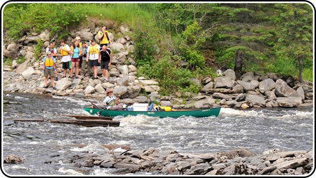
This geocache site is located 1.5 miles downstream from Churchill Dam. The section of river below the dam is called Chase Rapids; it is a difficult class II section of river. The cache is actually located at the first major pool in the river below the dam, known as Big Eddy. The site may be accessed by canoe or by using the portage trail on the west side of the river.
While at Churchill you should visit the History Center in the barn located on the east side of the river. You are welcome to use the campsites at the dam for a picnic lunch or for an overnight stay. A ranger should be near waterway facilities at the dam; they will be happy to answer any questions you have about the area.
Churchill Dam maybe reached using private logging roads from the south via the Golden and Telos Roads or from Ashland to the east via the Pinkham and 522 Roads. A Maine Atlas and Gazetteer by Delorme is highly recommended for navigating on these logging roads. A well serviced vehicle with good clearance and tires is a must. Day use fee is required and payable at landowner checkpoints as you enter the area. Logging trucks have the right of way, pull over when you see one!
Park Details
Allagash Wilderness Waterway
Established 1966
A federally designated Wild and Scenic River, the Allagash Wilderness Waterway is a canoe camper’s paradise. This 92-mile river corridor is surrounded by a vast, privately owned commercial forest. The area also is used extensively in the winter for ice fishing and snowmobiling even though there are no groomed trails. Look for the passport station at Chamberlain Bridge Ranger Station, Churchill Dam Ranger Station, Umsaskis Ranger Station, and Michaud Farm Ranger Station.
CAUTION: Trips to this remote region require careful planning. There is no cell phone reception in this area. Contact the Maine Division of Parks and Public Lands at (207) 941-4014 for more information.
Maine State Parks Geo Tour
 Those willing to take exploring Maine State Parks to a higher level are invited to participate in the Maine State Parks Geo Tour! Geocaching is an outdoor adventure game similar to a treasure hunt, but is played with a GPS device. The object is to locate containers (called caches) hidden at eight specified parks. There are over two million geocaches around the world, and now with the Maine State Parks Geo Tour you have “Another Way to Play at Maine State Parks & Historic Sites!”
HOW TO PLAY:
- Obtain a Maine State Parks Passport from any Maine state park or historic site (or use your existing passport).
- Go to www.geocaching.com to create your login.
- Download the GPS coordinates to your GPS unit or mobile device for each of the 8 locations (listed below).
- Using the coordinates, find as many Maine state parks geocaches (during normal park hours of 9 a.m. to sunset and between mid-May and Sept.) as you can! The hidden, water-tight containers will be clearly marked as official Maine State Parks Geocaches.
Hint: caches are only located at the following Maine State Parks:
- Sign the logbook inside each container, and stamp your passport with the unique stamp from that park’s geocache.
Learn More about Maine State Parks and Historic Sites:
go to: