 |
| |
Rio Lagartos coastal lagoon, on the northern coast of the Yucatan Peninsula in the Gulf of Mexico. The lagoon is very shallow (0.5-1.0 m), 80 km long, and 94 km 2 surface area. In the western zone, the lagoon has three permanent mouths (one natural and two artificial) that permit exchange of water with the Gulf of Mexico.
The water is all shades of pink, because of a small organism that lives in it, called artemia. This is also the preferred food of the Flamingos and they get their pink color by eating them.
The Yucatan's flock of Flamingos is estimated at 40,000 and there are always Flamingos in the Ria Lagartos Biosphere Reserve. The bio reserve is especially suited for flamingos because of the highly saline water. High salinity is favorable for their prefered diet, brine shrimp (artemia). The feeding and nesting grounds are distant from the only entrance in the estuary to the Gulf of Mexico.
The distance to the opening increases the salinity via evaporation and this is the reason for large quantity of artemia and the salt production that has occured here continually since the Mayan period at least. |
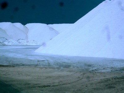 |
The salt dunes of Las Coloradas,
Yucatan with storm coming in |
| |
|
Long before the Spanish invaded this part of the world, the Maya were extracting salt from the lagoons of the north coast of Yucatan. A peculiar combination of natural circumstances allows the generation of high-quality salt from the natural estuaries, baked under an unrelenting sun. The water gradually evaporates, leaving salt.
This salt is distinctively different from mined salt and according to some chefs, far superior.
The ria, or river, that extends from Rio Lagartos into Las Coloradas is normally separated from the sea by a strip of land. This preserves the lagoons of the rias for making salt. On several ocassions in the last twenty years, hurricanes have eradicated the barrier between the ocean and the freshwater rias, ruining the production of salt. Now, ISYSA (Industrial Salineros de Yucatan SA de CV), the privately owned salt company, has erected plastic dividers intended to prevent this. The plastic dividers are hidden under mounds of sand.
The ria salt production ponds are a spectacular pink, due to the gradual evaporation of the water and the high concentration of salt. How often do you see a pink lake?
|
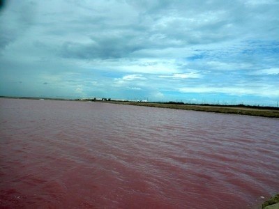 |
| A pink saltpan |
| |
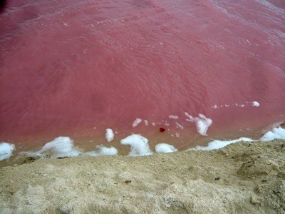 |
| Foam at the edge of the pink lake is pure salt |
| |
|
However, superficial as we try to be on this site, focussing on the picturesque and thrilling, the sight of the salt dunes and the bright pink salination ponds is nothing short of spectacular.
The process has been refined over the last century, and now the sea salt production facility on the north coast ships salt all over Mexico and Latin America. ISYSA produces about half a million tons of salt per year.
Source by Beryl Gorbman.
|
| |
|
To log this earthcache, perform the following tasks:
As usual for an EarthCache there is no logbook at the coordinates! To log this cache, please take some saltwater with you. Place it into the sun and follow as well as document the salt evaporation and send your results of findings (happy as a sketch).
After that you can Log your visit and if anything is wrong I'll get back to you. That will shows you how the salt extraction works. You need no Internet to solve the task. If you like you can add a picture of you with your GPS with the Red Salt Lake in the background or of the experiment (this is not needed and optional).
|
| |
 |
| |
| Rio Lagartos laguna costera , en la costa norte de la Península de Yucatán en el Golfo de México. La laguna es muy poco profundo (0,5-1,0 m), 80 km de largo, y 94 km 2 de superficie. En la zona occidental , la laguna tiene tres bocas permanentes (una natural y dos artificial) que cambio del permiso de agua con el Golfo de México.
El agua es todos los tonos de rosa, a causa de un pequeño organismo que vive en ella, llamado artemia. Este también es el alimento preferido de los flamencos y consiguen su color rosado por comerlos.
Rebaño del Yucatán de flamencos se estima en 40 000 y siempre hay Flamencos en la Reserva de la Biosfera Ría Lagartos. La reserva biológica es especialmente adecuado para los flamencos por el agua altamente salina. Alta salinidad es favorable para su dieta preferida, la artemia (Artemia). Las zonas de alimentación y anidación están lejos de la única entrada de la ría hasta el Golfo de México .
La distancia a la abertura aumenta la salinidad a través de la evaporación y esta es la razón para la gran cantidad de artemia y la producción de sal que ha ocurrido aquí continuamente desde el período maya por lo menos.
|
|
Las dunas de sal de Las Coloradas,
Yucatán con tormenta en |
| |
| Mucho antes de que los españoles invadieron esta parte del mundo , los mayas estaban extrayendo la sal de las lagunas de la costa norte de Yucatán. Una peculiar combinación de circunstancias naturales permite la generación de sal de alta calidad a partir de los estuarios naturales, horneados bajo un sol implacable. El agua se evapora poco a poco , dejando la sal.
Esta sal es claramente diferente de la sal extraída y según algunos chefs , muy superior.
La ría , o de un río , que se extiende desde Río Lagartos en Las Coloradas se separa normalmente del mar por una franja de tierra. Esto preserva las lagunas de las rías para la producción de sal. En varias ocasiones en los últimos veinte años , los huracanes han erradicado la barrera entre el océano y las rías de agua dulce, arruinando la producción de sal. Ahora, ISYSA (Industrial salineros de Yucatán SA de CV , la compañía de sal de propiedad privada, se ha erigido separadores plásticos destinados a prevenir esto. Los separadores de plástico están ocultos bajo montones de arena.
Los estanques de producción de sal Ria son un rosa espectacular , debido a la evaporación gradual del agua y la alta concentración de sal . ¿Con qué frecuencia se ve un lago de color rosa?
|
|
| Una cacerola de sal rosa |
| |
|
| Espuma en el borde del lago rosado es sal pura |
| |
|
Sin embargo, superficial ya que tratamos de estar en este sitio, se centra en el pintoresco y emocionante, a la vista de las dunas de sal y las brillantes estanques de salinización de color rosa no es nada menos que espectacular.
El proceso se ha perfeccionado a lo largo del siglo pasado, y ahora la planta de producción de la sal del mar en los barcos Costa Norte de sal en todo México y América Latina. ISYSA produce alrededor de medio millón de toneladas de sal al año.
Fuente por Beryl Gorbman.
|
| |
|
Para iniciar este Caché Tierra, realice las siguientes tareas:
Como es habitual para un Caché Tierra no hay ningún libro de registro en las coordenadas! Para iniciar esta caché, por favor tome un poco de agua salada con usted. Colóquelo en el sol y seguir así como el documento de la evaporación de sal.
Después de iniciar la sesión de su visita y si algo está equivocado pondremos en contacto con usted. Esa voluntad que cómo funciona la extracción de sal muestra. Usted no necesita ninguna de Internet para resolver las preguntas. Si lo desea, puede hacer una foto de usted con su GPS con el lago rojo de la sal en el fondo (esto no es necesario, pero bueno si lo haces).
|