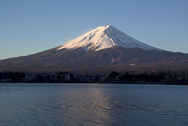
[JP]
富士山は標高3776mの日本最高峰の活火山です。
[EN]
Mt. Fuji is the highest mountain in Japan with the height of 3776 m and an active volcano.
富士山の噴火史/Eruption history of Mt. Fuji
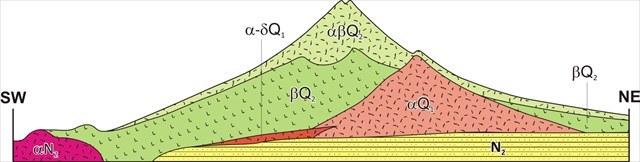
[JP]
富士山の構造は、下図のように、小御岳火山(αQ2)、古富士火山(βQ2)、新富士火山(αβQ2)に分けられます。
[EN]
The structure of Mt. Fuji is as shown in the figure below with Komitake volcano (αQ2), Old Fuji volcano (βQ2) and New Fuji volcano (αβQ2).
火山活動開始期/Beginning of volcanic activity
[JP]
富士山の周辺一帯は数百万年前から火山活動が活発であったことが知られています。この時期は、伊豆半島がユーラシアプレートに衝突した時期と一致しており(私の他のEarthcacheである丹那断層参照)、この衝突のエネルギーにより火山活動が活性化されたものと考えられています。
[EN]
It is known that volcanic activities around the present Mt. Fuji started about several million years ago, which coincided with the time when Izu peninsula started to collided with Japan island (see my another Earthcache "Tanna fault"). It is assumed that the energy of this collision activated the volcanic activity there.
小御岳火山/Komitake volcano
[JP]
約70万年前、現在の富士山の位置に小御岳(こみたけ)火山が活動を始めました。
[EN]
About 700 thousands year ago, Komitake volcano started its activity at the place of the present Mt. Fuji.
古富士火山/Old Fuji volcano
[JP]
小御岳火山がしばらく休止した後、約10万年前から新たな活動時期に入りました。この時期を古富士火山と呼びます。古富士火山は爆発的な噴火が特徴で、大量のスコリア・火山灰や溶岩を噴出し、標高3000mに達する大きな山体を形成していきました。
約1万1000年前に噴火の形態が大きく変わり、その後約2000年間は断続的に大量の溶岩を流出させました。富士山の溶岩は、珪酸成分が少ない玄武岩質で、粘性が低くて流動性が良く(珪酸成分の増加とともに溶岩の粘性も増加します)、遠くまで流れる傾向があります。この時期に噴火した溶岩は最大40kmも流れており、南側に流下した溶岩は駿河湾に達しています。
[EN]
After Komitake volcano took a pause for a while, a new volcanic activity started 100 thousands year ago, which is called as "Old Fuji volcano". Old Fuji volcano was characterized in that it had explosive eruptions, eructed a lot of volcanic scoria, ash and lava, and formed a huge mountain body with a height of up to 3000m above the sea level.
About 11 thousands years ago, the type of eruption changed dramatically, a lot of lava flew out continually for 2 thousands years. The lava of Mt. Fuji is basaltic, containing less silicate. It has a low viscosity and a high flowability(the more silicate it contains, the more flowable it becomes), tends to flow a long way. The lava during this era flew over 40 kilometers long and reached Suruga bay in the south.
新富士火山/New Fuji volcano
[JP]
古富士火山の溶岩流のあと約4000年間平穏でしたが、約5000年前から新しい活動時期に入り、現在に至るこの火山活動を新富士火山と呼びます。確認されている最後の大噴火は1707年の宝永大噴火であり、この噴火により、側火山側火山である宝永山の噴火口ができました。
[EN]
There was a calm period for about 4000 years after the lava flow of Old Fuji volcano, but new volcanic activities started about 5000 years ago. The volcanic activities since then to the present is called as "New Fuji volcano". The last major eruption confirmed was Houei eruption in 1707, which created the eruptive crater of Mt. Houei as a lateral volcano.
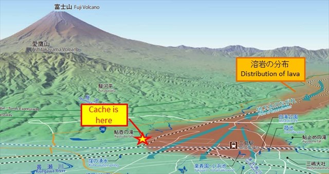
三島溶岩/Mishima lava
[JP]
三島溶岩は、約1万年前に流出した溶岩です。南に流れた三島溶岩は、現在の三島市まで達し、愛鷹ローム層を覆いました。このキャッシュは、三島溶岩の下流端のところに設置されています(下図参照)。
[EN]
Mishima lava flew out about 10 thousands years ago, reached current Mishima city, and covered loam layer there. This Earthcache is placed at the end of Mishima lava (see the figure below).
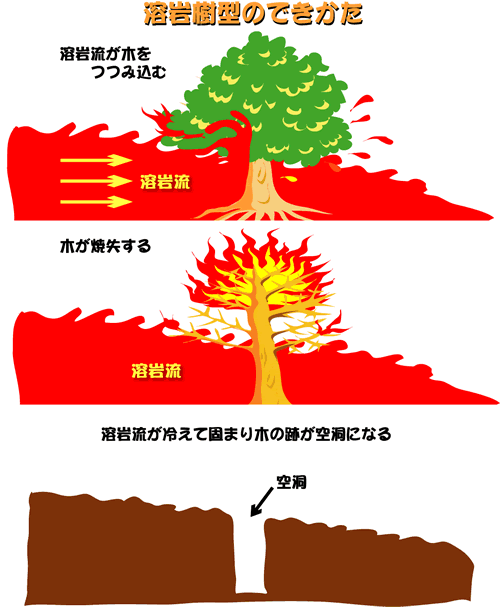
溶岩樹型/Lava tree mold
[JP]
火山から噴出された後に地表を流れる溶岩により形成される地形的特徴の1つに「溶岩樹型」があります。溶岩樹型は、(1)溶岩流が木を包み込み、(2)溶岩が冷えて固まる一方、木は焼失し、(3)溶岩中に空洞が残される、ことによって形成されます(下図参照)。
[EN]
One of geological features formed by lava which is erupted from a volcano and flow on the ground surface is "lava tree mold". Such a lava tree mold is formed by the steps of (1) lava flow encompassing a tree, (2) the lava getting cold and solidified, while the tree burning out, (3)a hollow being left in the lava (see also the figure below).
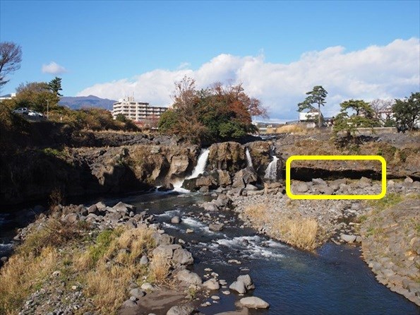
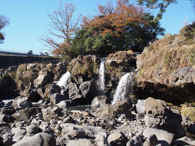
鮎壺の滝/Ayutsubo fall
[JP]
公開座標には、三島溶岩により形成された地形の一つである鮎壺の滝があります(下写真)。この滝は、三島溶岩の上を流れてきた黄瀬川が、溶岩の末端から流れ落ちることにより形成されています。
[EN]
There is Ayutsubo fall at the published coords (see the picture below), which fall is one of the geological features formed with Mishima lava. Kise river running down on Mishima lava falls from the edge of the lava and forms the fall.
Task
[JP]
以下のQ1-Q2の答えをCache ownerに送ってください。
Q1. 河原に降りて溶岩の層を下から見上げると(下写真の枠内あたりを見ると良いでしょう)、溶岩中に縦に伸びる複数の穴が空いていることが分かります。これらの穴は溶岩樹型でしょうか? もしそうだとすると、何故その様に言えるでしょうか?穴の内側面の観察結果を踏まえて答えてください。
Q2. かつて地表にあった愛鷹ローム層が溶岩の下に露出していることが観察できます。このローム層と溶岩層の性質を比較してみましょう。また、滝の前には崩落した溶岩の大きな塊が横たわっています。ローム層と溶岩層の性質の違いと、滝の下の溶岩の塊の存在から、三島溶岩流下後に、鮎壺の滝がどのように形成されたかについて、あなたが考えたシナリオを答えてください。
[EN]
Send to the cache owner your answers to the questions, Q1-Q2 below:
Q1. Going down to the bottom of the fall, look up the lava layer from its bottom side, and look at some holes vertically extending into the lava (it would be better to observe the portion encompassed by the frame in the picture below). Are those holes lava tree mold? If so, why can you say so? Please answer based on the result of your careful observation of the inner walls of the holes.
Q2. You can observe under the lave that there exposed the loam layer which used to be the land surface. Please compare the characteristics of the lava layer and loam layer. In addition, you can notice that there lie huge masses of lava rock in front of the fall. What is the scenario of how the fall has been formed you think based on the difference between the characteristics of the lava layer and loam layer, and the existence of the masses of lava rock in front of the fall?