Geology Rocks Series (No.2) -WHAT LIES BENEATH? EarthCache
Geology Rocks Series (No.2) -WHAT LIES BENEATH?
-
Difficulty:
-

-
Terrain:
-
Size:  (other)
Please note Use of geocaching.com services is subject to the terms and conditions
in our disclaimer.
Watsons Bay sits on the end of the South Head peninsula and takes its name from the sheltered bay and anchorage on its western side, in Sydney Harbour.
The Gap is an ocean cliff on the South Head peninsula in eastern Sydney, New South Wales. It is a sandstone cliff, below which extends a WAVE CUT SHELF or PLATFORM. But this platform is a bit special.
Below the Gap this wave cut platform exposes a TESSELLATED PAVEMENT
There are several really good earthcaches in the locality that explain the predominant bedrock, Hawkesbury Sandstone, well. But this earthcache is concerned with an underlying phenomenon and how it was revealed. This is an earthcache there is no physical container to find.
In geology and geomorphology, a TESSELLATED PAVEMENT is a relatively flat rock surface that is subdivided into more or less regular rectangles, blocks approaching rectangles, or irregular or regular polygons by fractures, frequently systematic joints, within the rock. More often in limestone, not sandstone like this.
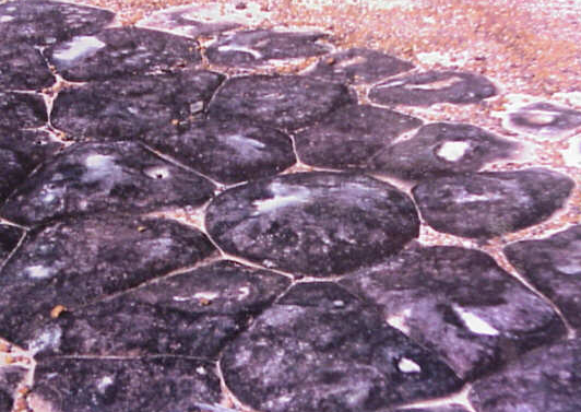
This type of rock pavement bears this name because it is fractured into polygonal blocks that resemble tiles of a mosaic floor, or tessellations.
Four types of tessellated pavements have been recognised. They are (a) formed by jointing; (b) by cooling contraction; (c) by mud cracking and lithification, (the process in which sediments compact under pressure); and (d) sandstone pavements of uncertain origin
The most common type of tessellated pavement consists of relatively flat rock surfaces, typically the tops of beds of sandstones and other sedimentary rocks, that are subdivided into either more or less regular rectangles or blocks approaching rectangles by well-developed systematic orthogonal joint systems.
The surface of individual beds, as exposed by erosion, are typically divided into either squares, rectangles, and less commonly triangles or other shapes, depending on the number and orientation of the joint sets that comprise the joint system. This relatively flat surface of individual beds of sedimentary rocks are frequently altered by weathering along joints as to cause the bedrock along the joints to be either raised or recessed as the result of differential erosion.
This type of tessellated pavement is visible here because wave action has created relatively flat and extensive wave-cut platforms that expose jointed bedrock and keeps the surfaces of these platforms relatively clear of debris.
This earthcache is concerned with the tessellated pavement consisting of relatively flat, sandstone surfaces that typically exhibit a complex pattern of polygons. Typically, these polygons vary greatly in size.
These polygons are defined by well-developed fractures that sometimes have raised rims. They are found within exposures of the Hawkesbury Sandstone within the Sydney Basin.
Tessellated rock platforms lie at the base of the cliff because The Gap is bordered to the south and west by an older sequence of largely low-grade metamorphic and granitic rocks of the Lachian Fold Belt. Sub-terrainean earth movements generate heat and pressure which alters bedrock. These NEW rocks are harder and more resistant. There is evidence too, of basalt intrusion. That is, magma has squirted in between beds from deep underground.
HEAT AND PRESSURE HAS CAUSED A CHANGE IN THE NATURE OF THE SOME OF THE BED ROCK.
Hydraulic action is the predominant process in exposing the pavement.
The headland and bay were formed when the sea attacked a section of coast with overlying HORIZONTAL bands of softer rock.
The bands of soft rock erode more quickly than those of more resistant rock below.
LOGGING REQUIREMENT
VISIT THE SITE, then email us your responses. Go ahead and log your find, but PLEASE don't put answers in your log. I will you contact ASAP
BINOCULARS OR A CAMERA + ZOOM LENS MAY BE HELPFUL
(1) You can see some wearing away, erosion, in the 'soft' rocks underneath the bluff?? What can you see?(Without leaning over the fence!)
(2) The underlying shelf is hard and resistant. Anything down there resembling tiles or a mosaic? (= tessellation) Mention the size, colour, any polygons, patterns you can see.
(3) The pavement is a harder, a different type of rock NOW. What might have caused the change in the bedrock? (Hint -answer in the text).
A photo of you and/or group would be nice!
Congratulations on a very swift FTF by Kid Ron Satan!!!
Additional Hints
(Decrypt)
OVABPHYNEF BE N YBAT PNZREN YRAF ZNLOR URYCSHY ohg cyrnfr qba'g cbfg nal tvirnjnl cubgbf!
QBAG YRNA BIRE!!!