Efes Limanı: Tüm su nereye gitti? (Türkçe)
Ephesus harbour: Where has all the water gone? (English)
Efes Limanı: Tüm su nereye gitti?
Antik Efes kenti bir zamanlar Küçükmenderes nehri kenrında önemli bir liman kentiydi ama zaman içinde kentin civarı alüvyon ile doldu ve sahil çizgisi doğuya doğru kaydı. Bugün Ege Denizi Efes harabelerinden sekiz kilometre uzakta.
Efes’in jeolojik kaderi
Bronz devri sırasında Ege kıyısı karaya doğru hareket ederek Efes Körfezini oluşturdu. Ondan sonra Küçükmenderes nehrinin tortuları körfezi doldurmaya başladı ve kıyı çizgisini batıya doğru geriletti. Sürekli kazılarak yapılan boşaltmaya rağmen, nehir Efes’in ticaret merkezi olarak öneminin düşmesini sağladı. Limanının kaybolması, Efes’in Ege Denizi’ne olan bağlantısının yok olmasını sağladı, ki bu bağlantı bu önemli liman ve ticaret kenti için vazgeçilmezdi.
Efes’in ölümü ardındaki jeoloji
Burada gözlemlenebilen jeolojik olay çökelme ya da alüvyonlaşma diye bilinir. Bu terim akarsuların taşıdığı kütleler ile kara seviyesinin yükselmesini anlatır.
Alüvyon, akarsuyun nehir yatağında aşağıya taşıdığı ve çökelen kütlelerle oluşur. Tipik bir alüvyon dolgusunun oluşması gelen kütlenin sistemin taşıdığından daha fazla olmasıyla olur. Nehir deltaları, ki Küçükmenderes Nehrinin eskiden olanı en büyüklerinden biri olarak bilinir, tipik alüvyon bölgeleridir.
Burada bilinmesi gereken bir diğer önemli jeolojik terim de mendereslenmedir. Bu bir nehrin alkış yolunun kıvrılarak ilerlemesini tanımlar. Menderesler nehir yatağı düşük taban eğimine sahip olduğunda ve nehir çok kütle taşıdığında oluşur. Her iki durum da Efes Körfezinin alüvyon ile dolmasını hızlandırmıştır.
Menderes terimi Efes için özel bir öneme sahiptir, çünkü Türkiye’de bulunan (iki) Menderes Nehrinde (eski Yunanca: Μαίανδρος) gelir. Küçükmenderes Nehrinin mendereslenme dönemi eskilerde kaldığından bugün çok iyi gözlemlenemediğinden, bu EarthCache sadece alüvyonlanmaya odaklanacak. Mendereslenme ile ilgili daha fazla ayrıntılar için size Bremerhaven, Almanya’daki başka bir EarthCache’i tavsiye ederiz: Mäander. Bir başka güzel örnek ise ABD’deki Mississippi Nehridir: bakınız here ya da here.
Şehre gidiş yolunuz & kayıt için gerekenler
Earth Cache Arkeolojik alanın üst girişinden başlar ve alt girişinde sona erer. Cache için kayıt izni alabilmeniz için bu eski caddelerden aşağı doğru inerken 4 noktayı ziyaret etmeniz ve soruları yanıtlamanız gerekmektedir. Lütfen koyu olarak yazılmış olan görevlere bakınız ve yanıtları şu GC profillerinden (J ya da ts) birine gönderiniz. Gönderdikten sonra çevrimiçi kayıtı hemen herhangi bir onay beklemeden yapabilirsiniz. Bir farklılık olması durumunda bis sizinle irtibata geçeriz. Sizinle iletişime kurabilmemiz için lütfen mesajınızla birlikte e-posta adresinizi de gönderdiğinizden emin olunuz.
- Sayfa başında yayınlanan koordinatlarda Antik Şehrin bir minyatürünü bulacaksınız. Burada net bir şekilde kolonlarla bezenmiş Liman Caddesi sonunda yer alan mavi ile boyanmış limanı görebileceksiniz. Bu resmi geçmişin bir resmi olarak aklınıza yerleştirin ve aşama 2’ye geçin.
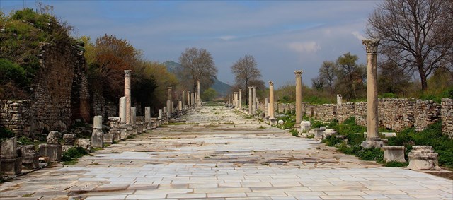
- S2 (Aşama 2)’ye geçince yüzlerce yıllık zaman yolculuğunuza başlayacaksınız. İzleme noktasından, liman da dahil olmak üzere tüm şehiri görebilirsiniz. Burada da farkına varacaksınız ki bugün limandan kalanlar S1 de göreceğiniz resimdekinden çok da farklı değildir. Ne gemiler, ne ticari hareketlilik ne de ve en önemlisi su bulunmaktadır.
Görev 1: Kendi sözlerinizle limanın bugünkü durumunu tanımlayınız. Tamamen kuru mu? Tamamen kum ve çakılla dolu olan limanın şeklini nasıl anlarsınız? Batıya doğru uzanan topraklarda daha önce nehir olduğunun kanıtını nasıl anlarsınız? Denizi görebiliyor musunuz?
- Gelin birkaç yüzyıldır burada neler olduğunu birlikte bulalım. Bugün kendinizi çok kuru bir ortamda bulmanıza rağmen, Efes’in altın çağlarında burada su bulunuyordu. Bu dramatik değişim, Jeolojik zamanda çok kısa bir sürede olmasına rağmen, Jeoloji ile açıklanabilir.
Öncelikle antik insanların kendi zamanlarında bu jeolojik değişimlerle nasıl başa çıktığına odaklanacağız. Aşama 3’te (S3) limanın tarihi hakkında daha çok şey öğrenebileceğiniz bir bilgi paneli bulacaksınız.
Görev 2: Hangi yüzyıldan beri liman denize yapay bir kanal ile bağlanmıştır ve geriye dönüp baktığınızda bu neden anlamsız bir hareket olmuştur?
- Şimdi S4de havzaya daha ayrıntılı bakma imkanınız var. Tarihi limana Liman Caddesinden direkt ulaşım, döşeme malzemesinin korunması için kapalıdır. Limana yan taraftan giden iki yol da her zaman kullanılamadığından, bu aşamada yapılacak bir görev yoktur. Bu aşamayı geçmişteki deniz ticaretinin karmaşasını hissedebilmeniz için bir fırsat olarak değerlendirebilirsiniz. Burada ayrıca 2. aşamadaki gözleminizi doğrulayabilirsiniz.
- Son olarak, tarihi liman ile bugünkü limanın neden bu kadar farklı olduğunu anlamak için, S5e gidiniz. Burada yine bilgi panoları göreceksiniz. Bir tanesi Efes’in jeolojisine yoğunlaşmıştır.
Görev 3: Sahil çizgisinin zaman içinde hareketini kendi kelimelerinizle kısaca anlatınız.
Görev 4: Haritada şaşırtıcı bir şekilde 1.,2. ve 3. aşamalarda gördüğünüz limandan daha fazlasını göreceksiniz. Kendi kelimelerinizle kısaca limanın yerinin tarih boyunca neden bir kaç kez değiştirildiğini yazınız. Daha önceki sorulara verdiğiniz cevapları göz önünde bulundurarak, yukarıda bahsedilen jeoloji ile, tarihte insanların bu sürekli değişen jeolojiye uyum sağlama çabaları konusunda bağlantı yapın. Efes kenti harabeleri bu jeolojik değişimler için neden iyi bir belirleyicidir?
- (İsteğe bağlı) Görev 5: Lütfen kendinizin ve/veya GPS cihazınızın alanda herhangi bir yerde çekilen fotoğrafını çevrim içi kaydınıza ekleyin (şu anki EC kurallarına göre bu bir ricadır, mecburi değildir).
Oraya nasıl gidersiniz
Efes antik kentinin iki ayrı girişi vardır, her ikisinde de park yeri vardır (bakınız P1 ve P2). Lütfen kişi başı 30 TL giriş ve park ücreti ödemeniz gerekeceğini göz önünde bulundurun. EC üst girişten başlamanız üzere düzenlenmiştir ama ters de olur.
Ephesus harbour: Where has all the water gone?
The ancient city of Ephesus was once an important harbour city on the banks of the Küçükmenderes River ("Little Meander”), but over time, sedimentation gradually filled in the inlet around the city. The coastlines moved eastwards and today the Aegean Sea is eight kilometres away from the ruins of Ephesus.
Ephesus’ geological fate
Till the period of the Copper Age the Aegean coastline was moving inland and formed the Gulf of Ephesus. Then the sedimentation of the Küçükmenderes River began to silt up the bay and to put back the coastline to the West. Ephesus' importance as a commercial centre declined as the harbour was slowly silted up by the river despite repeated dredging. The loss of its harbour caused Ephesus to lose its access to the Aegean Sea, which was essential for such a prominent harbour and trade city.
The geology behind the demise of Ephesus
Geologically the phenomenon that can be observed here is known as aggradation or alluviation. The term stands for the increase in land elevation (in a river system) due to the deposition of sediment.
Silt is material that is carried downstream by running water and deposited in the river bed as sediment. Typically aggradation occurs when the supply of sediment is greater than the amount of material that the system is able to discharge. River deltas like the former one of the Küçükmenderes River (known for its great deal of suspended alluvial deposits) are typical aggradational environments.
Another important geological term to know about here is meander. It describes a bend in the watercourse of a river resulting in a snaking pattern. Meanders are formed when the river bed has a low bottom slope and the water contains a lot of deposits. Both aspects accelerated the aggradation of the Gulf of Ephesus.
The term meander itself is of special importance in Ephesus, because it derives from the (two) Meander River(s) (ancient Greek: Μαίανδρος) here in Turkey. But since the meander period of the Küçükmenderes River lies in the past and cannot be observed very well today, this EarthCache will only focus on aggradation. For further details on meander we would like to refer you to an EarthCache in Bremerhaven, Germany, dealing with this topic: Mäander. Another good example is the Mississippi River in the United States: see here or here.
Your way through the city & log requirements
The EarthCache starts at the upper entrance to the archaeological site and finishes at the lower entrance. On your way down the old streets you will have to visit four stages and to answer questions in order to get the log permission. Please have a look at the tasks in boldface below and send us the answers via one of our GC profiles (J or ts). After submission you are allowed to log online immediately without waiting for further approval. In case of any discrepancies we will contact you. Please make sure you've sent your e-mail address along with your message so that we can contact you directly.
- Close to the head coordinates you will find a miniature edition of the ancient city. You can clearly see the blue water-filled harbour at the end of the colonnaded Harbour Street. Keep this as a picture of the past in mind and proceed to stage 2.
- When moving on to S2 you will travel hundreds of years forward through time. From the viewpoint there you have a good overview of the city including the harbour. You will notice that what is left of the harbour today couldn't be more different from the picture that you saw at S1. There are no ships, no brisk trading and most important: no water!
Task 1: Describe the current status of the harbour in your own words. Is it completely dry? How can you recognise the shape and the size of silted-up harbour? Try to recognise evidence for the former river course in the landscape to the West. Can you see the ocean?
- Let's find out what happened here in the last couple of hundreds years. As you have seen at stage 1 there used to be water in the heydays of Ephesus whilst today you find yourself in a very dry environment. This dramatic change can be explained by geology, although it happened in a geologically very short time frame.
As a first step we will focus on how the ancient people tried to cope with the geological changes in their time. At S3 you will find an information panel and you can learn more about the history of the harbour.
Task 2: Since which century has the harbour been connected to the sea by an artificial canal and why was that a senseless act retrospectively? Remember the landscape that you saw at stage 2.
- Now there is the option to have a closer look at the basin at S4. Please note that the direct way over the ancient Harbour Street is permanently cordoned off to preserve the flooring material. Since the two outer paths to the harbour are also not exposable at all times there is no task to fulfill at this stage. Just consider this stage as a bonus and try to feel the bustle of the bygone maritime trade here. You can also confirm the observation here that you did from stage 2.
- To finally find out why the ancient and the current harbour are so different, move on to S5. Again you will find some information panels. One focuses on the geology of Ephesus.
Task 3: Describe briefly the coastline as it moved over time in your own words.
Task 4: On the map you will surprisingly find more than the harbour that you just saw at the stages 1, 2 and 4 . Explain briefly in your own words why the harbour needed to be moved several time in history. Keep in mind your answer to the last question and make a connection between the geology described above and how the ancient people tried to adapt to continuously changing geology. Why do the ruins of Ephesus represent a good marker for geological changes?
- Task 5: Take a picture on site and post it along with your online log. The picture has to either show your GPS device or your GC nick name written on a piece of paper or on your hand in front of the ruins. In accordance with the updated EC guidelines this is an obligation effective 10th June 2019. Logs without the requested photo proof will be deleted after 24 hours.
How to get there
The archaeological site of Ephesus has two separate entrances, both connected to distinct parking lots (see P1 and P2). Please note that you will have to pay an entrance fee of 30 TL/person and an additional parking fee. The EC is designed to start from the upper entrance, but it also works the other way round.
References & further reading
- Ref 1: Österreichisches Archäologisches Institut
- Ref 2: JC Kraft, H Bückner, I Kayan and H Engelmann: "The Geographies of Ancient Ephesus and the Artemision in Anatolia" (Geoarchaeology, 2006)
- Ref 3: F Stock, M Kerschner, JC Kraft, A Pint, P Frenzel, & H Brückner: "The palaeogeographies of Ephesos (Turkey), its harbours, and the Artemision - a geoarchaeological reconstruction for the timespan 1500 - 300 BC." (Zeitschrift für Geomorphologie, 2014)
- Ref 4: diverse Wikipedia articles: Aggradation, Alluvium, Ephesus, Küçükmenderes River, Meander, Sediment Transport
Acknowledgment
We would like to thank AnDéRsSoN, haoral and sel-ist for their kind support with the Turkish translation. Teşekkürler!