Experimente und Beobachtungen am Nordsee-Strand EarthCache
Experimente und Beobachtungen am Nordsee-Strand
-
Difficulty:
-

-
Terrain:
-
Size:  (other)
Please note Use of geocaching.com services is subject to the terms and conditions
in our disclaimer.

Experimente und Beobachtungen am Nordsee-Strand
Der Earthcache führt Euch an den Sandstrand von St. Peter Ording. Ein Strandspaziergang bietet mehr als eine schöne Aussicht. Bereits seit Anfang des 20. Jahrhunderts beschäftigen sich Physiker mit der Bildung von gleichmäßigen wellenartigen Erhebungen und Vertiefungen im Sand, den sogenannten Sandrippeln. Dieser Earthcache führt in den Nationalpark Schleswig-Holsteinisches Wattenmeer, ein gesetzlich geschütztes Biosphärenreservat. Bitte verhaltet Euch angemessen; lauft nicht durch Dünen oder Salzwiesen. Stört keine Tiere.

"Sandrippel sind eines der bekanntesten Beispiele für Selbststrukturierung in der Natur", sagt Prof. Ingo Rehberg von der Universität Bayreuth, "und es nervt den Physiker, dass er das Rätsel des Sandes noch nicht versteht".
Das Problem daran ist, dass Sand, auch in Verbindung mit Wasser, keine Flüssigkeit und auch kein Festkörper ist. Sand ist ein natürlich vorkommendes, unverfestigtes Sediment, das sich überwiegend aus Mineralkörnern zusammensetzt. Grundlage sind die Forschungen der englische Physikerin Hertha Ayrton von 1910. Sie simulierte die Entstehung von Rippeln mit mehreren eigentlich einfachen Versuchen: Ein Aquarium mit Sand und Wasser wurde gleichmäßig hin- und herbewegt, die Strömungen machte sie mit gemahlenem Pfeffer sichtbar. Durch ihre Erkenntnisse durfte sie als erste Frau ihre Arbeit über die Rippelmuster vor der angesehenen Royal Society vortragen.
Die Landschaft wird durch die Gezeiten neu geformt, in dem lockerer Sand bei Ebbe bzw. Flut transportiert wird. Dabei können eine Reihe unterschiedlicher Sedimentstrukturen entstehen, unter denen die verschiedenen Typen der Rippeln die auffälligsten sind. Genau um diese Rippeln geht es uns hier..
Strömungsrippel
Aus einer ersten minimalen Erhöhung entsteht ein Hindernis in der Oberfläche des Sandbodens, an der sich von der Strömung mitgerissene Sandkörner anlagern können. Je größer das Hindernis, desto mehr Körner lagern sich an (Positive Rückkopplung). Das Ergebnis sind asymmetrische Strömungsrippel mit einer flachen Luv- und einer steilen Leeseite.
Diese Skizze verdeutlicht den Vorgang.
Aquatische Strömungsrippel entstehen in Sand, wenn die Strömungsgeschwindigkeit knapp über der kritischen Geschwindigkeit liegt. Strömungsrippel sind asymmetrisch, mit einer geringeren Hangneigung auf der strömungszugewandten Luvseite und einer steileren Hangneigung auf der strömungsabgewandten Leeseite. Die Höhe von Rippeln liegt im Durchschnitt bei 3–5 cm, ihre Wellenlänge bei 4–60 cm. Damit Rippel entstehen, benötigt man eine Mindestwassertiefe von etwa 3-facher Rippelhöhe. Da die Rippelbildung von den Prozessen in der Grenzschichtlage bestimmt wird, ist die Maximaltiefe für die Rippelbildung nach oben hin nicht begrenzt. Der maximale Sandkorndurchmesser für die Entstehung von Rippeln liegt bei 0,6–0,7 mm. Bei größeren Korndurchmessern entstehen Großrippel und Riesenrippel. Rippeln und Großrippeln sind nicht stationär, sondern wandern in Richtung der Strömung.
Oszillationsrippel
Diese auch Wellen- oder Gezeitenrippel genannten Strukturen entstehen, wenn die Strömung über den Sand oszilliert, d. h., abwechselnd aus unterschiedlichen, im Idealfall entgegengesetzten Richtungen kommt. Der Idealfall ist z. B. an einem flachen Strand gegeben, auf dem das Wasser im entgegengesetzten Sinn in die Richtung zurückläuft, aus der die antransportierende Welle hereinkam. Aber auch jede Oberflächenwelle erzeugt auf dem Boden Hin- und Herbewegung. Das Ergebnis dieser Pendelbewegungungen sind Rippelmarken mit einem symmetrischen Querschnitt. Nach ihrer Größe werden Rippel in drei Gruppen unterteilt: Rippel, meist zwischen 3 und 5 cm hoch und mit einer Wellenlänge von 4–60 cm Großrippel, zwischen 6 cm und 1,5 m hoch und mit einer Wellenlänge zwischen 0,6 und 30 m Riesen- oder Megarippel, zwischen 1,0 und 8,0 m hoch, mit einer Wellenlänge größer als 30 m Groß- und Riesenrippel entstehen bei Korngrößen von mehr als 0,6–0,7 mm. Nur die Riesenrippel sind stationär, die übrigen Rippel wandern mit der Strömung. Rippelmarken sind – im Gegensatz zu Belastungsmarken – Strukturen an der Oberseite einer Sedimentschicht. Beide können somit zur Bestimmung der ursprünglichen Lagerung des Sedimentes dienen (Geopetalgefüge).
(Quellenhinweis: Rippel – Wikipedia)
Log-Bedingungen
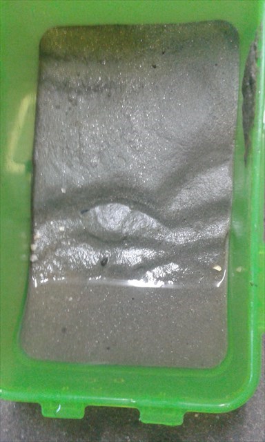
1. Wiederholt den Versuch von Hertha Ayrton. Nehmt dazu z.B. eine der klassischen Small-Click-Cachedosen. Jetzt braucht ihr noch ein wenig Sand (ca. 2 cm Höhe) und darüber etwa 2 cm Wasser. Dann gleichmäßig horizontal in Längsrichtung hin und her schieben. Das Ergebnis hängt insbesondere von der Art des Sandes ab, Maurersand geht z.B. nicht. Den richtigen Sand gibt es hier am Strand in Hülle und Fülle. In eurer Mail beschreibt ihr bitte genau eure Erfahrungen bei dem Experiment, vergleicht eure Rippel mit denen am Strand bzw. im Watt und gebt an, welche der beiden Arten von Rippeln bei euch entstanden sind. Wir würden uns über ein freiwilliges Foto Eures Versuches sehr freuen.
2. Finde einen Strömungsrippel am Strand. Beschreibe die Form und messe die Wellenlänge und Höhe.
3. Unter dem Einfluss von Wind wachsen - wie bei Wasser - zufällige Anhäufungen, Mulden vertiefen sich – bis schließlich ein ganzer Strand mit Rippeln überzogen ist. Deshalb befinden sich die Rippeln nicht nur im feuchten Watt, sondern auch im trockenen Sand abseits der Brandung. Bestimme daher auch die Windrichtung und berichte in deinem Log über das Ergebnis und deine Mess-Methode.
Ein Foto von Dir oder deinem GPS - natürlich auf freiwilliger Basis.
Schicke uns eine eMail über unser Profil mit deinen Antworten. Du kannst den Cache direkt loggen, falls etwas nicht stimmen sollte, werden wir uns bei Dir melden
Wie erfolgt die Logfreigabe bei einem EarthCache?
english version
The Earthcache lead you to the sandy beach of St. Peter Ording. A walk on the beach offers more than a nice view. Since the beginning of the 20th century, physicists deal with the formation of uniform wavelike elevations and depressions in the sand, the so-called sand ripples.This Earthcache leads in the Schleswig-Holstein Wadden Sea National Park, a proprietary Biosphere Reserve. Please conduct yourself appropriately; do not run through the dunes or salt marshes.
"Sand ripples are one of the best known examples of self-assembly in nature," says Prof. Ingo Rehberg of Bayreuth University, "and it annoys the physicist that he still does not understand the mystery of the sand".
The problem here is that sand, also in conjunction with water, not liquid and not a solid body. Sand is a naturally occurring, unconsolidated sediment that mainly composed of mineral grains. Basis, the research, the English physicist Hertha Ayrton of 1910. They simulated the formation of ripples with several really simple experiments: An aquarium with sand and water was equally reciprocated the currents made them visible with ground pepper. Through her findings she became the first woman present their work on the ripple pattern in front of the prestigious Royal Society.
The landscape is reshaped by the tide and wind, is transported into the loose sand at low tide or high tide. This can create a number of different sedimentary structures arise, under which the various types of ripples are the most striking. Exactly at these ripples we are doing here ..
flow ripple
From a first minimal increase arises an obstacle in the surface of the sandy soil, can accumulate on which entrained by the flow of sand grains. The greater the obstacle, the more grains are deposited on (positive feedback). The result is asymmetric flow ripple with a flat windward and leeward side of a steep.
Aquatic flow ripple arising in the sand, when the flow rate is just above the critical speed. Flow ripple are asymmetrical, with a lower slope on the flow facing windward side and a steeper slope on the flow leeward facing away. The height of ripples is on average 3-5 cm, its wavelength at 4-60 cm. This ripple arise, you need a minimum water depth of about 3-fold ripple height. Since the ripple formation is determined by the processes in the boundary layer situation, the maximum depth of the ripple formation upwards is unlimited. The maximum sand grain diameter for the formation of ripples is 0.6-0.7 mm. For larger grain diameters caused large ripple and giant ripple. Ripples and large ripples are not stationary, but travel in the direction of flow.
Oszillationsrippel
These structures also referred to wave or tidal ripple arise if the flow over the sand oscillates, ie, alternately coming from different, opposite directions in the ideal case. The ideal case is z. B. given on a shallow beach, on the back running the water in the opposite sense in the direction from which came the antransportierende shaft. However, any surface acoustic wave generated on the ground reciprocation. The result of this Pendelbewegungungen are ripple marks with a symmetrical cross-section. According to their size Rippel be divided into three groups: Rippel, mostly 3 to 5 cm high and with a wavelength of 4-60 cm large ripple, between 6 cm and 1.5 m high and having a wavelength from 0.6 to 30 m Giant or Mega Rippel, 1.0 to 8.0 m high, with a wavelength greater than 30 m large and giant ripples occur at grain sizes of more than 0.6-0.7 mm. Only the giant ripples are stationary, the remaining ripple migrate with the flow. Ripple marks are - in contrast to load brands - structures on top of a layer of sediment. Both can therefore to determine the original storage of sediment serve .
Log-conditions
1. Repeats the test of Hertha Ayrton. Take this for example, with a classic small-Click Cache doses. Now you need a little sand (approx 2 cm high) and above about 2 cm of water. Then slide evenly horizontally longitudinally back and forth. The result is particularly dependent on the type of sand, mason sand goes eg not. The correct sand there are on the beach in abundance. In your mail you please describe exactly your experience in the experiment, compares your Rippel with those on the beach or in the Wadden and give to, which have arisen with you of two kinds of ripples. We are looking forward to a voluntary photo of your experiment very.
2. Locate a flow ripple on the beach. What shape is the? Measure the height and wavelength!
3. Under the influence of wind grow - like water - eventually to an entire beach with ripples is covered - random accumulations, wells deepen. Therefore, the ripples are not only in the wet watt, but also in the dry sand away from the surf. Therefore, determine the wind direction and reports in your log of the outcome and your measurement method.
A photo of you or your GPS - of course on a voluntary basis.
Send us an email with your answers. You can sign in directly to the cache, if there is something wrong, we will contact with you
Additional Hints
(No hints available.)