Bog or Fen?
Cowles Bog is considered a fen, rather than a 'true' bog since it is more alkaline than a bog such as nearby Pinhook Bog, also a part of the Indiana Dunes National Lakeshore. The main body of the bog is composed of muck created from marsh plants and the woody plants that have encroached into the area. Surrounding the bog proper is an area covered with a thin layer of leaf litter over a thin layer of topsoil. The area is moderately acidic. Wet depressions exist which reveal a substratum of Maumee soils, a loamy fine sand. These loamy sands extend southward through the marsh area. To the north the dunes consist of Plainfield fine sand, which is heavily oxidized.
Cowles Bog is not a true bog but rather a fen because it has an underground water source. This water source has contact with limestone bedrock, making the fen's water slightly alkaline. Indiana Dunes National Lakeshore is restoring a portion of this fen.
Fens
Fens, are peat-forming wetlands that receive nutrients from sources other than precipitation: usually from upslope sources through drainage from surrounding mineral soils and from groundwater movement. Fens differ from bogs because they are less acidic and have higher nutrient levels. They are therefore able to support a much more diverse plant and animal community. These systems are often covered by grasses, sedges, rushes, and wildflowers.
Some fens are characterized by parallel ridges of vegetation separated by less productive hollows. The ridges of these patterned fens form perpendicular to the downslope direction of water movement. Over time, peat may build up and separate the fen from its groundwater supply. When this happens, the fen receives fewer nutrients and may become a bog.

The Fen in this area was formed here, when glaciers retreated, leaving a lake, followed by shallow depressions, heading towards the parking area. These low depressions were left with soil over a water saturated gravel/sand base This is evident towards the parking area in the sand/Gravel zone. Over time the water saturated the land forming the FEN.
Bogs
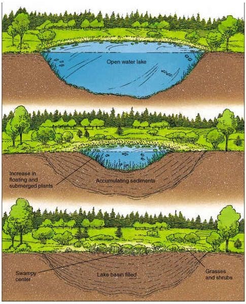
Bogs are characterized by a sizable accumulation (>40 cm) of peat and have a relatively high water table with very little inflow or outflow of water or none at all. These sites have very low productivity, contain few mineral nutrients, are very acidic (pH levels of 3–5), and are covered with a layer of floating vegetation. Many bogs have developed in the depressions created by the melting of the ice during the glacial retreat some 10,000 years ago. Over time, these glacial lakes have amassed large volumes of organic material, gradually converting them into peat bogs.
Other bogs have formed in sloughs and low depressions where there is limited or no drainage.
As you take the journey from the parking area at 41° 38.217'N 87° 5.229'W
you will not need to leave the trail to complete this earthcache.

The trail takes you along the northern edge of 'Cowles Bog'. The trail consist of three loops beginning at the Cowles Bog Trailhead parking area. Lake Michigan can be reached on this trail in only 1.7 miles (2.7 km) by using the most direct route.
-
The southern loop is 2.0 miles (3.2 km) long around the bog, with a return trip of about 0.8 miles (1.3 km) along Mineral Springs Road.
-
The middle loop is 1.7 miles (2.7 km) and takes you into the dunes ridges and interdunal wetlands. It requires that you use the southern loop 0.8 miles (1.3 km) to get to and from it.
-
The northern loop is connected to the middle loop and is 1.4 miles (2.3 km) long, crossing the foredunes and reaching Lake Michigan. This is the highest of the dunes and the steepest portion of the trail.
Logging requirements
I am going to ask you to collect information as you walk along the trail.
1) Explore and describe the ground along the trail. Note how wet or dry each area is,
2) Explore and describe the vegetation as you walk along the trail.
3) Grab a stick, and see how far can you push it into the ground.
4) Look and explore at the soil in the water. Describe the texture and make up of this soil. Does it contain sand, gravel etc or is it just mud?
5) Tell me why you believe this is a Fen and not a Bog.
6) Post a picture of yourself (face not required) or a personal item