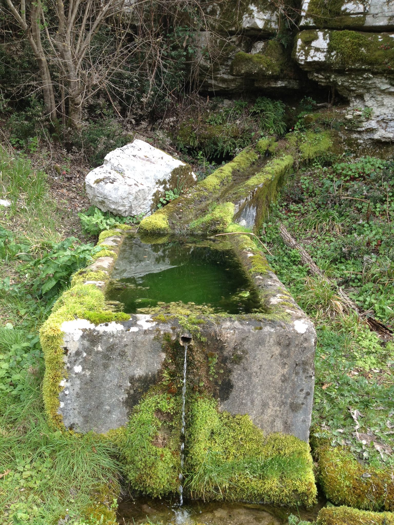
Izvori Kašteljir nalaze se blizu Kanfanara i bili su važni za opskrbu pitkom vodom dok grad nije dobio vodovod. Uz izvore su kasnije napravljeni kanali u kojima se skupljala voda i preko pročistača ispuštala u veliku cisternu. Nekad su Kanfanarke, dok je bila suša, u brentama nosile vodu na leđima do svojih kuća .
Podzemna voda je voda koja se nalazi ispod površine Zemlje unutar šupljina i pora u tlu i u stijenama.
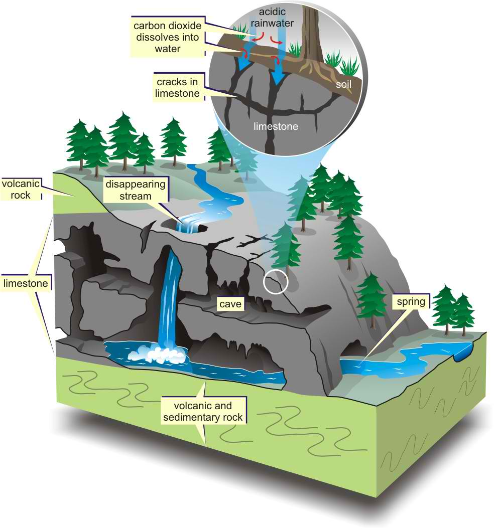
Od ukupne količine slatke vode na Zemlji 30% se nalazi u podzemlju kamo dolazi infiltracijom ili gravitacijskim procjeđivanjem s površine.
Kretanje vode kroz slojeve tla u slojeve sedimenta i stijena ispod površine Zemlje naziva se infiltracija. Tri faktora mogu povećati infiltraciju vode u podzemlje:
1. Povećanje razmaka među česticama – Što je veći razmak među česticama stijena to je veća količina vode koja može završiti u podzemlju. Na primjer, rast korijenja stabala može povećati razmak među stijenama, te se na taj način povećava infiltracija vode.
2. Smanjenje nagiba terena – U slučaju ravnih terena voda ima veću šansu da prodre u unutrašnjost, dok kod strmih terena voda otječe s lokacije prije infiltracije u podzemlje.
3. Smanjenje količina oborina – U slučaju većih količina oborina, ne dolazi i do veće infiltracije, nego se u tom slučaju povećava količina vode koja otječe s lokacije.
Dvije su osobine stijena koje određuju količinu vode koja će se u nekom sloju stijena zadržati – poroznost i propusnost.
Poroznost stijena može biti definirana kao postotak šupljina u datom volumenu stijene. Poroznost stijena može biti primarna i sekundarna. Primarna poroznost je ona poroznost koja je nastala u stijeni prilikom njezinog postanka. Sekundarna poroznost karakterizira čvrste stijene koje su naknadno bile izložene nekim silama; u većini slučajeva radi se o tektonskim silama.
Propusnost stijena opisuje lakoću kojom se voda može kretati kroz stijenu. Propusnost je određena poroznošću, ali i načinom na koji su pukotine u stijenama međusobno povezane. Prema propusnosti, geolozi razlikuju tri vrste stijena: vodopropusne, polupropusne i vodonepropusne stijene.
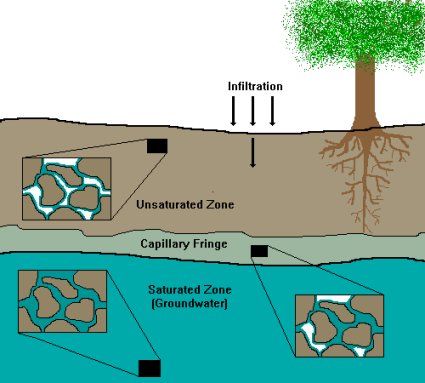
Vodna ploha je granica između gornjeg nezasićenog područja (zona aeracije ili vadozni pojas) i donjeg zasićenog područja (zona saturacije).
Prozračna zona ili zona aeracije je prostor ispod površine pa sve do vodne plohe. Kroz ovu zonu prolazi voda s površine koja napaja podzemnu vodu. Dio tih voda ostaje zadržan u prozračnoj zoni molekularnim i kapilarnim silama - talna i kapilarna voda.
Ako je vodna ploha toliko duboko ispod površine da kapilarna voda ne doseže do talne vode, između njih postoji međupojas, odnosno vadozna zona, kroz koju se povremeno procjeđuje voda s površine u podzemlje.
Zasićena zona ili zona saturacije je zona ispod vodne plohe u kojoj su sve pore i pukotine u stijenama ispunjene vodom. Ovu vodu nazivamo podzemna voda ili voda temeljnica. Dakle, gornju granicu podzemne vode čini vodna ploha ili vodno lice = razina vode u zdencima ili bunarima.
Kretanje podzemne vode utječe na okolinu i stvara različite geološke oblike: izvore, vodonosnike, špilje, sige, gejzire itd.
Izvori su mjesta pojavljivanja vode na površini ovisi o prirodnim karakteristikama stijena i lokalnim hidrogeološkim odnosima. Izvori se često nalaze na nagibima gdje dolazi do sjecišta površine Zemlje i vodne plohe, što omogućava podzemnoj vodi da istječe na površinu.
Vodonosnik je podzemni sloj koji sadrži vodu, a može biti propustljiva stijena, pukotine u stijeni ili nekonsolidirani materijal poput šljunka, pijeska ili mulja. Iz vodonosnika se voda može crpiti, na primjer putem bunara.
Špilje i jame su podzemna područja koja su šuplja. Mogu nastati pod utjecajem podzemne vode na način da podzemna voda protječe kroz stijene koje su topljive u vodi, te se na taj način formiraju šupljine koje se daljnjim protokom vode povećavaju i formiraju u špilje i jame. Špilje i jame su otvorenim dijelom izravno spojene s površinom.
Stalaktiti i stalagmiti su objekti koji nastaju u špiljama kada voda kaplje sa stropa špilje. Stalaktiti i stalagmiti rastu zato što voda koja kaplje sadrži otopljene minerale koji formiraju stalaktite i stalagmite. Stalaktiti rastu sa stropa špilje, dok stalagmiti rastu s poda špilje. Stalaktiti i stalagmiti se mogu spojiti u jedan stup, te se tada takav stup naziva stalagnat.
Gejzir je tip termalnog izvora iz kojega periodično izbija vruća voda i para. U slučaju gejzira, podzemna voda izbija na površinu zbog visoke temperature do koje je došlo zagrijavanjem podzemne vode duboko ispod površine. Podzemnu vodu u tom slučaju zagrijava magma duboko u zemljinoj kori. Temperatura vode u gejziru je blizu točke vrelišta (100° C).
Da bi mogli logirat Earthcache postavit ću Vam nekoliko pitanja, a Vi mi pošaljite odgovore na mail, ne morate čekat moj odgovor već slobodno logirajte, ako nešto nije u redu kontaktirat ću Vas.
1. Istražite lokaciju ovoga earthcachea. Koje sve geološke oblike nastale pod utjecajem podzemne vode možete zapaziti?
2. Dolazi li podzemna voda koja ovdje izvire u kontakt s magmom? Objasnite svoj odgovor.
3. Napravite fotografiju sebe (fotografijom na kojima je gps/mobitel, ruka ili noga NE ispunjavate zadatak i log će biti obrisan) ili papira s vašim nikom sa lokacije EC-a te ju stavite u svoj log.
Uživajte u ovom predivnom mjestu!

Die Quellen Kašteljir sind in der Nähe von Kanfanar und sie waren wichtig für die Versorgung mit Trinkwasser bis Kanfanar das Wasser bekommen hat. Neben den Quellen wurden später Kanäle gemacht, wo man das Wasser sammelte und durch Filter in einer Grossen Zisterne sammelte. Früher bis die Dürre war trugen Frauen aus Kanfanar in Brentas Wasser auf dem Rücken zu ihren Häusern.
Das Grundwasser ist Wasser unter der Oberfläche der Erde und befindet sich innerhalb der Hohlräume und Poren im Boden und in den Felsen.
Von der Gesamtmenge des Süßwasser auf der Erde, befindet sich 30% unterirdisch, wo es durch Infiltration oder Versickerung durch die Oberfläche kommt.
Die Bewegung des Wassers durch die Bodenschichten in den Sedimentschichten und Felsen unterhalb der Erdoberfläche wird Infiltration genannt. Drei Faktoren können das Eindringen von Wasser in den Untergrund erhöhen:
1. Erhöhung des Porenvolumens zwischen den Partikeln – Wird das Hohlraumvolumen zwischen den Partikeln erhöht, kann das Sediment mehr Wasser aufnehmen. So schaffen beispielsweise Baumwurzeln, die in den Boden hineinwachsen, mehr Hohlraum und erhöhen damit die Infiltration.
2. Verringerung der Hangneigung – Ein flacher Erdboden kann mehr Wasser aufnehmen als ein steiler Hang, an dem das Regenwasser abfließt, bevor es in den Boden einsickert und zu Grundwasser werden kann.
3. Abnahme der Regenintensität –Fällt zu schnell zu viel Regen dringt das Regenwasser oft nur in die oberen Sedimentschichten ein und fließt zu einem großen Teil wider ab.
Wie viel Wasser eine Gestein- oder Sedimentschicht aufnehmen kann, läst sich mit Zwei Messgrößen beschreiben.
Die Porosität ist ein Maß für das Hohlraumvolumen zwischen den Partikeln und wird als prozentualer Anteil am Gesamtvolumen angegeben. Die Porosität des Gesteins kann primäre und sekundäre sein. Primäre Porosität ist die Porosität die entstanden ist im Gestein im Laufe deren Entstehung. Sekundäre Porosität charakterisiert das feste Gestein das bestimmten Kräften ausgesetzt war; In den meisten Fällen sind es tektonische Kräfte.
Die Permeabilität beschreibt, wie leicht Wasser in ein Gestein oder Sediment eindringen kann. Sie ist sowohl von der Porosität abhängig als auch von der Verbindung der Hohlräume untereinander, über die Wasser von einem Hohlraum in den nächsten fließen kann. Nach Permeabilität, Geologen unterscheiden drei Arten von Gesteinen: wasserdurchlässig , halbdurchlässige und undurchlässige Gestein.
Die Grenze zwischen der wasserungesättigten Zone und der wassergesättigten Zone wird als Grundwasseroberfläche bezeichnet.
Das Wasser dringt zunächst in eine Sediment- oder Bodenschicht ein, die als Wasserungesättigte Zone bezeichnet wird. Durch diese Zone gelangt das Wasser von der Oberfläche, die durch das Grundwasser gespeist. Teil dieses Wassers wird in der Wasserungesättigte Zone durch Molekular- und Kapillarwirkung zurückgehalten.
An einem gewissen Punkt erreicht das Wasser eine Zone, in der die Hohlräume zwischen den Sedimentpartikeln mit Wasser anstatt mit Luft ausgefüllt sind – die wassergesättigte Zone. Dieses Wasser ist das Grundwasser. Es macht die obere Grenze des Grundwasseroberfläche oder Grundwasserspiegel = Wasserstand in den Brunnen.
Die Bewegung des Grundwassers wirkt sich auf die Umgebung aus und bildet unterschiedliche geologische Formen: Quellen, Aquifer, Höhle, Tropfsteine, Geysire usw.
Eine Quelle ist ein Ort wo das Grundwasser auf die Oberfläche austritt, es hängt von den natürlichen Eigenschaften der Gesteine ab und den lokalen hydrogeologischen Verhältnis. Die Quellen befinden sich oft an Hängen wo es zur Schnitt der Erdoberfläche und der Wasseroberfläche kommt, was das austreten des Grundwasser an die Oberfläche ermöglicht.
Aquifer ist die Grundschicht die Wasser enthält, und kann durchlässiges Gestein sein, oder Risse im Gestein oder unkonsolidierten Materialien wie Kies, Sand oder Schlick. Aus dem Aquifer kann man Wasser beispielsweise mittels Bohrlöchern gepumpt werden,
Höhlen und Schachthöhlen sind unterirdische Bereiche, die hohl sind. Sie können entstehen unter der Wirkung von Grundwasser. Wenn Grundwasser durch das lösliche Gestein fließt, und immer größere Hohlräume hinterlässt. Höhlen und Schachthöhlen sind direkt mit der Oberfläche verbunden.
Stalatiten und Stalgmiten entstehen wenn Wasser von der Höhlendecke tropft. Sie wachsen, weil das tropfende Wasser gelöste Minerale enthält, die es am Tropfstein zurücklässt. Stalaktiten wachsen von der Höhlendecke nach unten und Stalagmiten wachsen vom Höhleboden aus nach oben. Die Stalaktiten und Stalagmiten koenen in der Mitte zusammen wachsen und bilden einen Stalagnat.
Ein Geysir ist eine Art von Wärmequellen, aus denen periodische Heißwasser und Dampf schießt. Beim Geysir, kommt das Grundwasser an die Oberfläche aufgrund der hohen Temperaturen. Das Grundwasser wird erhitzt durch Magma tief in der Erdkruste. Die Temperatur des Wassers im Geysir befindet sich nahe dem Siedepunkt (100º C).
Zum Logen dieses Earthcaches habe ich für Sie ein paar Fragen. Bitte die Antworten auf mein E-mail Adresse schicken. Sie müssen nicht auf meine Antwort warten, sondern können gleich Loggen, wenn was nicht korekt ist werde ich Sie kontaktieren.
1. Erforschung sie den Ort dieses Earthcaches. Welche geologische Formen unter dem Einfluss des Grundwassers können sie sehen?
2. Ist das Grundwasser was hier fließt in Kontakt mit Magma? Begründen Sie Ihre Antwort.
3. Mache ein Foto von sich selbst (Foto das ein GPS/Handy, Hand oder Bein zeigt, erfüllen NICHT die Aufgabe und werden gelöscht) oder Papier mit Ihrem Nick an der Lokation des EC und bitte zum Log hohladen.
Genießen Sie diesen wunderbaren Ort!

Kasteljir Springs are located near Kanfanar and they were important source of drinking water until Kanfanar got its water supply. Next to the springs channels were built and they were used for water collection and through purifier they were connected to cistern. In the past, women from Kanfanar brought water on their backs from Kateljir Spirngs in the time of drought.
Groundwater is water that is located under the surface of Earth inside cavities in the soil and rocks.
Out of total quantity of freshwater on Earth, 30% is located under the surface and it came there through infiltration and gravitational filtering.
Movement of water through the layers of sediment and rocks under the surface of Earth is called infiltration. Three factors can increase infiltration of water:
1. Increasing the space between particles – The more space between particles of rocks allows more water to end up underground. For example, the growth of tree roots increases the space between rocks and the infiltration of water can be increase in that way.
2. Decreasing the slope of the ground – In the case of flat surfaces the water has higher chance to infiltrate underground, while in the case of steep surfaces the water can run off from the location before its infiltration.
3. Lowering the intensity of rainfall – In the case of larger amount of rainfall infiltration will not be higher, but the opposite will happen – more water will run off from the location before infiltration.
Two characteristics of rocks determine how much water some rock layer will hold – porosity and permeability.
Porosity of rocks can be defined as the share of cavities in some rock volume. Rock porosity can be primary and secondary. Primary porosity is created when the rock itself is created. Secondary porosity is porosity that occurs after the rocks were formed, under the influence of different forces, mainly tectonic forces.
Permeability describes how easily water can move through the rock. Permeability is determined by both porosity and how well the spaces in rock are connected. According to permeability, geologists define three types of rocks: pervious, semi-pervious and impervious rocks.
Water table Water table is the boundary between the upper, unsaturated zone (zone of aeration) and the lower, saturated zone (zone of saturation).
Zone of aeration Zone of aeration is the area that extends bellow surface and all the way down to the water table. Water moves through this zone and becomes groundwater. Part of this water stays in the zone of aeration thanks to molecular and capillary forces, and it is called capillary water.
If the water table is deep bellow the surface and capillary water can’t reach the groundwater, between the water table and zone of aeration there is also a zone called capillary fringe area.
Zone of saturation is area bellow the water table. All cavities in this area are filled with water. This water, within zone of saturation is called groundwater.
So, upper boundary of groundwater is represented with the water table. It is also the level of water within wells.
The movement of groundwater affects its surroundings and it creates different geologic features, for example: springs, aquifers, caves, dripstones, geysers etc.
Springs are locations where groundwater flows out onto the surface. It is determined by the characteristics of the rocks and by local hydrogeologic characteristics. Springs are often located on slopes where water table intersects with the surface, and that enables groundwater to flow out on the surface.
Aquifer is underground layer where groundwater is stored, and it can be pervious rock, cavities within rocks or unconsolidated material like gravel, sand or silt. Water can be extracted from aquifers, by wells for example.
Caves and pits are underground hollow places. They can be formed by groundwater when groundwater flows through rocks that are soluble in water. In that way groundwater creates cavities that increase in size as additional water flows through them, and over the time they become caves and pits. Caves and pits are connected with the surface.
Dripstones are objects that form inside caves when water drips from the cave ceiling. They grow because the dripping water contains dissolved minerals that form dripstones. Two basic types of dripstones exist – stalactites and stalagmites. Stalactites grow from the ceiling of a cave, and stalagmites grow from the floor of a cave. Stalactites and stalagmites can merge together into one column and this column is called stalagnate or pillar.
Geyser is a type of thermal spring from which periodically flows hot water and steam. In geysers, groundwater flows up to the surface because of the high temperature of the water. It is caused by heating of groundwater, deep bellow the surface. Groundwater is heated by exposure to magma. Temperature of water in geyser is close to the boiling point (100° C).
In order to log this EarthCache I will ask you several questions and you should send your answers to my e-mail. You don’t have to wait for my confirmation, feel free to log the find as son as you send your answers. If there are problems with your answers, I will contact you.
1. Explore the location of this earthcache. Which geologic features created by the groundwater you can find here?
2. Does the groundwater that springs here come into contact with magma? Explain your answer.
3. Make a photo of yourself (photo showing a GPS/mobile phone, hand or leg do NOT fulfill the task and the log will be deleted) or paper with your nick from the location of the EC and put it to the log.
Enjoy this beautiful location!
Izvor:
Alecia M. Spooner : Grundlagen der Geologie für Dummies
Alecia M. Spooner, Geology for Dummies, Hoboken: Wiley Publishing, Inc., 2011.
Dunja Aljinović & Bruno Tomljenović: Površinska i podzemna voda (2.dio)
Veliko hvala GC Edo na pomoći, podršći i savjetima!
Souvenir/Banner:
Code: <a href="http://coord.info/GC6FGNB" ><img src="https://s3.amazonaws.com/gs-geo-images/715461fd-d217-4434-8176-8e70afe650d8.png" /></a>