In earth science, erosion is the action of surface processes (such as water flow or wind) that remove soil, rock, or dissolved material from one location on the Earth's crust, then transport it away to another location. The particulate breakdown of rock or soil into clastic sediment is referred to as physical or mechanical erosion; this contrasts with chemical erosion, where soil or rock material is removed from an area by its dissolving into a solvent (typically water), followed by the flow away of that solution. Eroded sediment or solutes may be transported just a few millimeters, or for thousands of kilometers.
Natural rates of erosion are controlled by the action of geomorphic drivers, such as rainfall; bedrock wear in rivers; coastal erosion by the sea and waves; glacial plucking, abrasion, and scour; areal flooding; wind abrasion; groundwater processes; and mass movement processes in steep landscapes like landslides and debris flows. The rates at which such processes act control how fast a surface is eroded. Typically, physical erosion proceeds fastest on steeply sloping surfaces, and rates may also be sensitive to some climatically-controlled properties including amounts of water supplied (e.g., by rain), storminess, wind speed, wave fetch, or atmospheric temperature (especially for some ice-related processes). Feedbacks are also possible between rates of erosion and the amount of eroded material that is already carried by, for example, a river or glacier Processes of erosion that produce sediment or solutes from a place contrast with those of deposition, which control the arrival and emplacement of material at a new location.
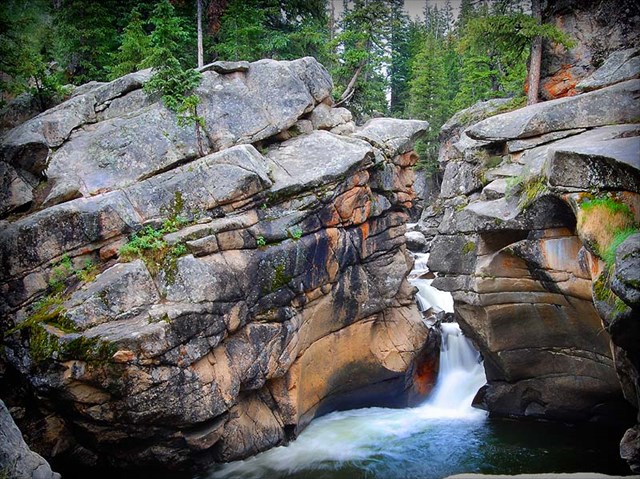
While erosion is a natural process, human activities have increased by 10-40 times the rate at which erosion is occurring globally. Excessive (or accelerated) erosion causes both "on-site" and "off-site" problems. On-site impacts include decreases in agricultural productivity and (on natural landscapes) ecological collapse, both because of loss of the nutrient-rich upper soil layers. In some cases, the eventual end result is desertification. Off-site effects include sedimentation of waterways and eutrophication of water bodies, as well as sediment-related damage to roads and houses. Water and wind erosion are the two primary causes of land degradation; combined, they are responsible for about 84% of the global extent of degraded land, making excessive erosion one of the most significant environmental problems world-wide. Hydraulic action is erosion that occurs when the motion of water against a rock surface produces mechanical weathering. Most generally, it is the ability of moving water (flowing or waves) to dislodge and transport rock particles. Within this rubric are a number of specific erosional processes, including abrasion, attrition, corrosion, saltation, and scouring.
Hydraulic action is distinguished from other types of water facilitated erosion, such as static erosion where water leaches salts and floats off organic material from unconsolidated sediments, and from chemical erosion more often called chemical weathering. It is a mechanical process, in which the moving water current flows against the banks and bed of a river, thereby removing rock particles.
Similarly, where hydraulic action is strong enough to loosen sediment along a stream bed and its banks; this will take rocks and particles from the banks and bed of the stream and add this to the stream's load. This process is the result of friction between the moving water and the static stream bed and banks. This friction increases with the speed of the water and the roughness of the bed. Once loosened the smaller particles are actually held in suspension by the force of the flowing water, these suspended particles can scour the sides and bottom of the stream. The scouring action produces distinctive markings on streams beds such as ripple marks, fluting, and crescent marks. The larger particles and even large rocks are scooted (dragged) along the bottom in a process known as traction which causes attrition, and are often "bounced" along in a process known as saltation where the force of the water temporarily lifts the rock particle which then crashes back into the bed dislodging other particles.
A CUT BANK, also known as a river cliff or river-cut cliff, is the outside bank of a water channel (stream), which is continually undergoing erosion. Cut banks are found in abundance along mature or meandering streams, they are located on the outside of a stream bend, known as a meander, opposite the slip-off slope on the inside of the bend. They are shaped much like a small cliff, and are formed by the erosion of soil as the stream collides with the river bank. As opposed to a point bar which is an area of deposition, a cut bank is an area of erosion.
A GROTTO (Italian grotta and French grotte) is any type of natural or artificial cave that is associated with modern, historic, or prehistoric use by humans. When it is not an artificial garden feature, a grotto is often a small cave near water and often flooded or liable to flood at high tide. Whether in tidal water or high up in hills, they are very often in limestone geology where the acidity dissolved in percolating water has dissolved the carbonates of the rock matrix as it has passed through what were originally small fissures.
To log this cache email us the following
1. What type of erosive feature do you see?
2. How many chambers can you see in this feature or describe the feature?
Permission for Earth Cache given by asst lake manager, Dennis Covey, Army Corp of Engineers, Lake Keystone, Oklahoma./p