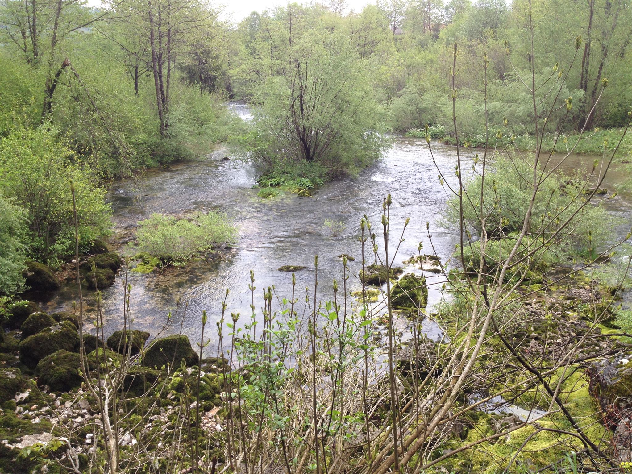
Podno Kleka u selu Vitunj, ispod ruševina istoimenog frankopanskog grada izvire Vitunjčica na slikovitom mjestu, između mahovinom obraslog kamenja, a koja se nakon četiri kilometra toka ulijeva u Gornju Dobru nedaleko sela Turković. Njen izvor nikad ne presušuje.
Izvori su mjesta gdje podzemna voda istječe na površinu i to se događa na mjestu gdje dolazi do sjecišta vodene plohe sa površinom Zemlje.
Izvori mogu nastati na nekoliko načina
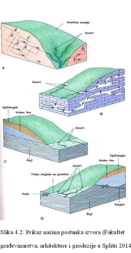
Podzemna voda je voda koja se nalazi ispod površine Zemlje unutar šupljina i pora u tlu i u stijenama. Vodna ploha je granica između gornjeg nezasićenog područja (zona aeracije ili vadozni pojas) i donjeg zasićenog područja (zona saturacije). Prozračna zona ili zona aeracije je prostor ispod površine pa sve do vodne plohe. Kroz ovu zonu prolazi voda s površine koja napaja podzemnu vodu. Dio tih voda ostaje zadržan u prozračnoj zoni molekularnim i kapilarnim silama - talna i kapilarna voda. Ako je vodna ploha toliko duboko ispod površine da kapilarna voda ne doseže do talne vode, između njih postoji međupojas, odnosno vadozna zona, kroz koju se povremeno procjeđuje voda s površine u podzemlje. Zasićena zona ili zona saturacije je zona ispod vodne plohe u kojoj su sve pore i pukotine u stijenama ispunjene vodom. Ovu vodu nazivamo podzemna voda ili voda temeljnica. Dakle, gornju granicu podzemne vode čini vodna ploha ili vodno lice = razina vode u zdencima ili bunarima.
Izvori se mogu klasificirati prema različitim kriterijima i u različitim grupama. Na primjer, prema temperaturi vode na izvoru, izvori se mogu klasificirat u tople i hladne izvore. Podjela između termalnih i netermalnih izvora fiksna je na 21°C(ili 70°F°). Prema načinu na koji voda istjeće na površinu izvori se mogu podjeliti na silazne i uzlazne izvore. Kod silaznog izvora voda izlazi na površinu pod utjecajem gravitacije, a kod uzlaznih izvora voda izlazi na površinu pod utjecajem hidrostatskog tlaka.
Prema prisutnosti minerala u vodi izvore možemo podjelit na mineralne izvore i obične izvore. Mineralni izvori su oni izvori gdje voda sadrži neobične količine mineralnih tvari, ili neke neuobičajene ili posebno primjetne mineralne tvari. Obični izvori ne sadrži nikakve minerale.
Još jedan popularan kriterij za klasifikaciju izvora je prema volumenu izviranja vode.
Klasifikacija prema volumenu izviranja vode je:
1. magnituda  –  više od 2800 litara u sekundi
2. magnituda –  280 do 2800 litara u sekundi
3. magnituda  –  28 do 280 litara u sekundi
4. magnituda  –  6.3 do 28 litara u sekundi
5. magnituda  –  0.63 do 6.3 litara u sekundi
6. magnituda  –  63 do 630 millilitara u sekundi
7. magnituda  –  8 do 63 millilitara u sekundi
8. magnituda  –  manje od 8 millilitara u sekundi
0 magnituda    –  nema protoka (presušeni izvor).
Da bi mogli logirat Earthcache postavit ću Vam nekoliko pitanja, a Vi mi pošaljite odgovore na mail, ne morate čekati moj odgovor već slobodno logirajte, ako nešto nije u redu kontaktirat ću Vas.
1. Istražite lokaciju ovoga earthcachea. Koliko izvora vidite na lokaciji?
2. Provjerite temperaturu vode na izvoru. Je li ovo termalni ili netermalni izvor?
3. Proučite istjecanje vode na ovom izvoru. Kako biste klasificirali izvor prema volumenu vode koja izvire na ovom izvoru?
4. Što mislite jel ovo silazni ili uzlazni izvor? Objasnite.
5. Napravite fotografiju sebe (fotografijom na kojima je gps/mobitel, ruka ili noga NE ispunjavate zadatak i log će biti obrisan) ili papira s vašim nikom sa lokacije EC-a te ju stavite u svoj log.
Uživajte u žuboru izvora!

At the foot of mountain Klek in the village Vitunj, under the ruins of the Frankopan city Vitunj, river Vitunjčica springs. It springs at this picturesque place, between the mossy stones and after four kilometers of stream it flows into the Gornja Dobra river near the village Turkovic. Its source never dries up.
Springs are locations where groundwater flows out onto the surface and it occurs at locations where water table intersects with the surface.
Sources can arise in several ways.
Groundwater is water that is located under the surface of Earth inside cavities in the soil and rocks. Water table is the boundary between the upper, unsaturated zone (zone of aeration) and the lower, saturated zone (zone of saturation). Zone of aeration is the area that extends bellow surface and all the way down to the water table. Water moves through this zone and becomes groundwater. Part of this water stays in the zone of aeration thanks to molecular and capillary forces, and it is called capillary water. If the water table is deep bellow the surface and capillary water can’t reach the groundwater, between the water table and zone of aeration there is also a zone called capillary fringe area. Zone of saturation is area bellow the water table. All cavities in this area are filled with water. This water, within zone of saturation is called groundwater. So, upper boundary of groundwater is represented with the water table. It is also the level of water within wells.
Springs can be classified according to different criteria into different groups. For example, according to the temperature of water at the spring, springs can be classified into thermal and non-thermal springs. The division between thermal and non-thermal springs is usually fixed at 21° C (or 70° F°). According to the method by which water flows out onto the surface, the springs can be divided into descending springs and ascending springs. In case of descending springs, water flows out onto the surface under the influence of gravity. In case of ascending springs, water flows out onto the surface under the influence of hydrostatic pressure.
According to the presence of minerals in the water, springs can be classified into mineral springs and common springs. Mineral springs are those which yield water containing in solution unusual amounts of mineral matter, or some uncommon or especially noticeable mineral matter. Water at common springs doesn’t contain such minerals.
Another popular criterion for classification of springs is the volume of the water they discharge.
The scale for classification is as follows:
1st magnitude  –  more than 2800 liters per second
2nd magnitude –  280 to 2800 liters per second
3rd magnitude  –  28 to 280 liters per second
4th magnitude  –  6.3 to 28 liters per second
5th magnitude  –  0.63 to 6.3 liters per second
6th magnitude  –  63 to 630 milliliters per second
7th magnitude  –  8 to 63 milliliters per second
8th magnitude  –  less than 8 milliliters per second
0 magnitude     –  no flow (locations of past springs)
In order to log this Earth Cache I will ask you several questions and you should send your answers to my e-mail. You don’t have to wait for my confirmation, feel free to log the find as son as you send your answers. If there are problems with your answers, I will contact you.
1 Observe the location of this earthcache. How many springs can you see at this location?
2. Check the temperature of water that springs here. Is this spring thermal or non-thermal spring?
3. Observe the outflow of water at this spring. How would you classify this spring according to volume of water it discharges?
4. What do you think, is this spring ascending or descending spring? Explain.
5. Make a photo of yourself (photo showing a GPS/mobile phone, hand or leg do NOT fulfill the task and the log will be deleted) or paper with your nick from the location of the EC and put it to the log.
Enjoy the murmur of sources!
Izvor:
Stjepan Miletić: Diplomski rad -GIS IZVORA VODA
Wikipedia
Hvala GC Edo na pomoći!
Hvala Aster i Aco da ste me poveli na put, te sam s vama otkrila ovaj predivan izvor!
Hvala Saši i Patriku Atanasovski koji su nas doveli na ovaj poseban izvor!