It is a line of weakness that probably featured in the earlier mountain building phase and perhaps reflects a more ancient line of weakness in the basement rocks.
Where you stand you can see part of a zone of faults and folds extending for dozens of kilometres across country northeast-wards from Swansea Bay up the Vale of Neath.
There are at least a couple more parallel faults to the north of Dinas Rock which, together with associated folds in the rocks, are collectively known as the Neath Disturbance.
The Dinas Fault Zone is effectively the entire width between the sheer walls of Dinas Rock and Bwa Maen and which contains a multiplicity of movement planes – surfaces which have slid past each other in the past.
Each time it moved, an earthquake shook the region. It is thought that the 1906 Swansea earthquake, centred on Swansea Bay may have occurred as a result of movement on this fault. Only a few weeks after the calamitous earthquake which destroyed large parts of San Francisco.
The Disturbance gives rise to a lineament crossing the region, that is to say that it is responsible for a number of significant landscape features along its 100km length. Prominent amongst these is the Vale of Neath, a deep valley incised by a glacier during the ice ages along this line of weakness in the Earth's crust and now occupied by the River Neath between waterfall country in Pontneddfechan and Swansea Bay.
There are two dramatic outcrops are a manifestation of a fault line – a line of great weakness in the Earth’s crust
Dinas Rock, in Welsh Craig y Ddinas, or "Fortress Rock", is a high promontory of Carboniferous limestone which rises between two little rivers on the border between the county of Powys and the county borough of Neath Port Talbot in South
It can be found near the village near Glynneath at the head of the Neath Valley It derives its name from the presence of Iron Age earthworks on its summit, dinas in Welsh signifying a defensive site or "city".
The steep and overhanging southern faces of Dinas Rock are popular with sports climbers whilst easier routes are enjoyed by organised groups in the former quarry at the western end of the rock. It is considered by some as the best inland cliff in South Wales for rock climbing.
Dinas Rock is one side of an anticline which is a type of fold that is an arch-like shape and has its oldest beds at its core. A typical anticline is convex up in which the hinge or crest is the location where the curvature is greatest, and the limbs are the sides of the fold that dip away from the hinge
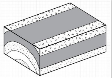
Limestone (the rock you see here) is formed from the deposition of hard mineral remains of sea creatures and chemically is mainly calcium carbonate CaCO3. This sedimentary rock mineral contains the 'shelly' remains of marine organisms, including coral, that once lived in warm shallow fertile seas. Limestone is grey-white in colour and contains fossils and sand grains. The 'shelly' remains, including coral, get buried and compressed and cemented together by the weight of water and other sediments. Limestone tends to form beneath warm shallow seas rich in plant and animal life.Limestone tends to be laid down horizontally.( Just as particles in muddy water settle in a jam-jar.) But huge global earth movements deform the solidified rocks, and horizontal bed can be seen often at an angle.
DIP is the measure used refer to the orientation or attitude of a rock bed. Essentially it is the slope of the rock. A real world example, if you imagine you are skiing down a slope. If you went straight down the hill (the “fall-line”) you would be skiing in the true dip direction.
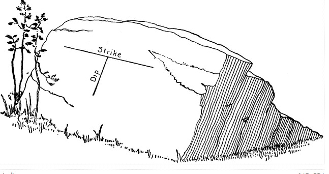 You can estimate the DIP angle or you might use some tool,a device or an app.
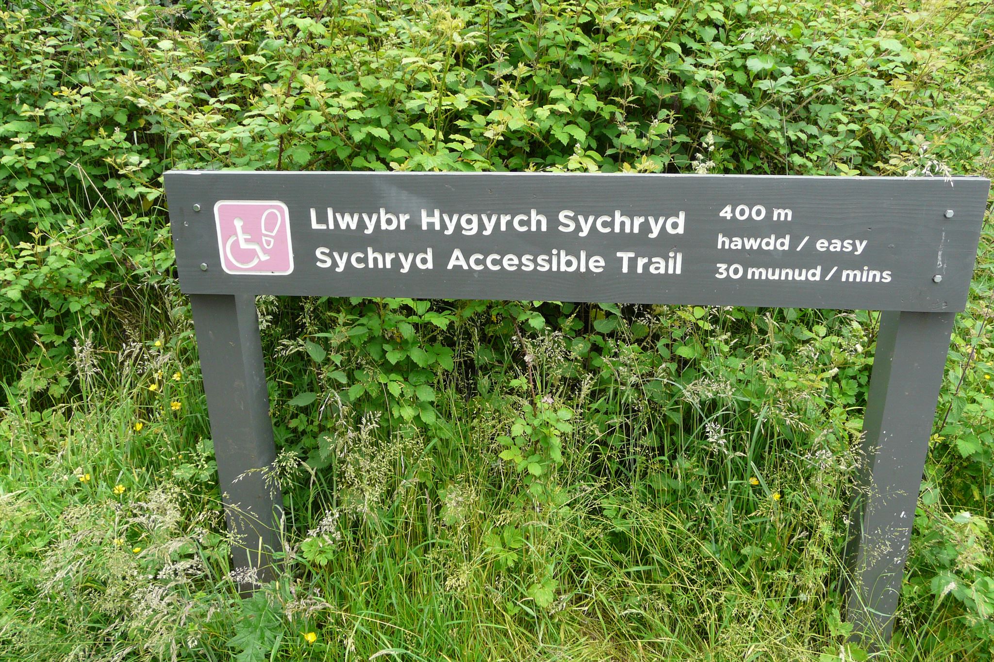
The other stunning feature is Bwa Maen, which is easily reached on foot from the Dinas Rock car park at the end of the road through Pontneddfechan. It is suitable for wheelchairs and pushchairs too, it’s only five minutes along the line of a former tram road beside the Afon Sychryd. This brings you to an impressive exposure of folded limestone. On the way, notice the "fault" , which is a crack in the earth's crust resulting in a displacement of the rocks one side with respect to the other.
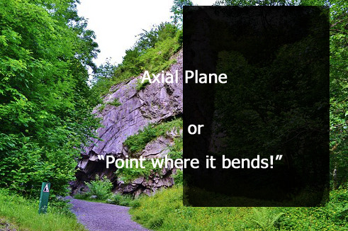
Bwa Maen, geologically speaking, is even more interesting. Its English name, ‘Bow of Stone’, reflects the way in which the rock has been squeezed from a horizontal to near vertical position, a process clearly visible in its arch-like folds. It is a tightly folded arch of Carboniferous Limestone that was squeezed and fractured long ago, then worn away. Its English name, ‘Bow of Stone’, reflects the way in which the rock has been squeezed from a horizontal to near vertical position, a process clearly visible in its arch-like folds.
References
- Howells, M.F. 2007 'British Regional Geology: Wales' Keyworth, Nottingham, British Geological Survey
CONGRATULATIONS ON FTF GOES TO IMBAMPS
DO GO to the coordinates and assess the landscape for yourself. Log the cache, and email or message your response to the following. I will reply as quickly as possible. (PICTURES ARE WELCOMED BUT please don’t post photos which would allow others to complete the cache from home!!)
LOGGING TASKS
To claim this earth cache.
PLEASE NOTE NEW NOTICE BOARDS HAVE BEEN INSTALLED CHECK THAT YOU HAVE THE REVISED QUESTIONS
(1) Estimate how high is the Dinas cliff in metres/ feet?
(2) What do you estimate the dip and its direction to be, in degrees and a compass point?
( HINT: The slope of the bed . Zero is horizontal. 90 degrees is perpendicular to the ground. The direction is the downhill slope away.)
(3) Complete the sentence from the notice board - "Bwa Main is the best rock exposure along the Neath Disturbance- _______________________________________________________________
(4) SEE NOTICE BOARD (or own knowledge) The rock is limestone laid down in warm coral seas how were the beds deposited?
(5) What may have caused its distorted appearance today?
(6) Estimate the size of Bwa Maen and say whether the anticlne is symmetrical?
(7) According to the NOTICEBOARD , when was the last earthquake in Swansea?

Thanks to "matthewgibbs" for the assistance.