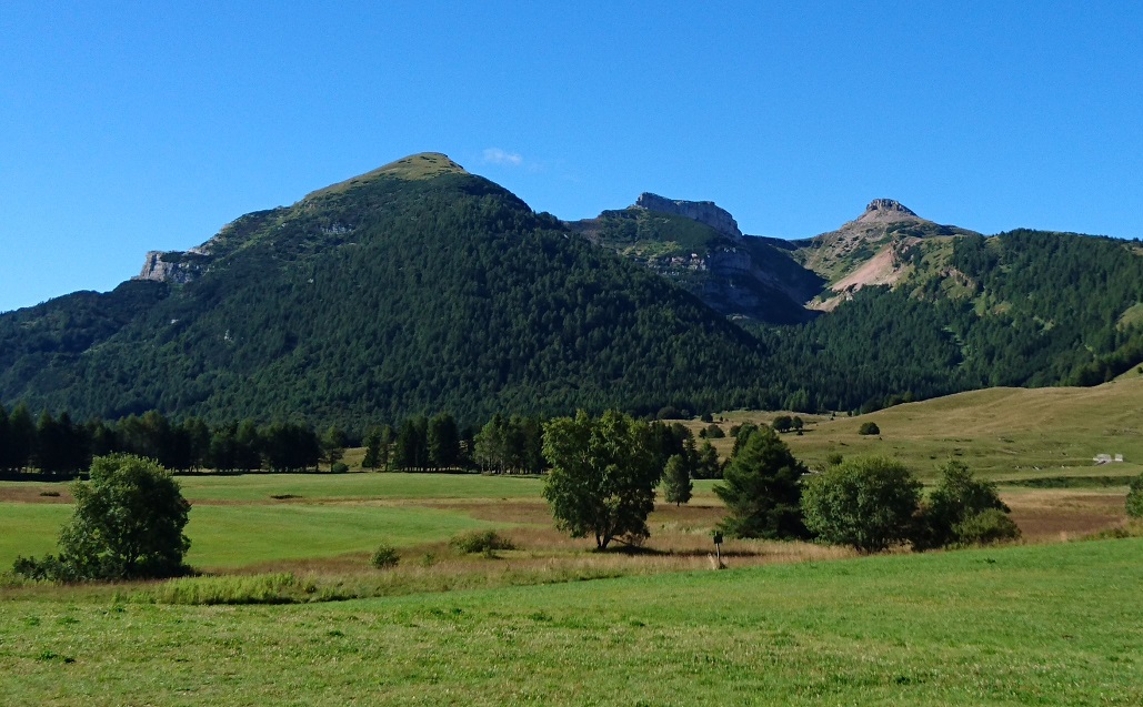

Il Monte Bondone si colloca nelle Alpi Retiche meridionali, appartenenti al dominio Sudalpino a sud della Linea Insubrica, e si erge immediatamente a ovest della città di Trento e del Fiume Adige con il complesso delle sue quattro cime: il Monte Palon (2.090 m s.l.m.), che si affaccia sulla Valle dell’Adige dominando la città, il Monte Cornetto (2.180 m s.l.m.), 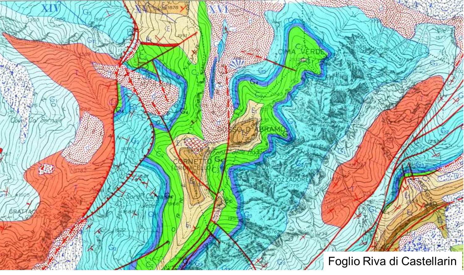
che rappresenta la cima più alta del massiccio montuoso, il Doss d’Abramo (2.140 m s.l.m.) e Cima Verde (2.102 m s.l.m.); quest’ultime in particolare rappresentano il complesso delle Tre Cime del Monte Bondone. Il Monte Bondone è delimitato a nord dalla forra del torrente Vela, a ovest si affaccia con la Rosta (1.832 m s.l.m.) sulla Valle dei Laghi e sul Basso Sarca, a est confina con la Valle dell’Adige, mentre a sud-ovest il gruppo montuoso si dirama dando luogo alla dorsale del Bondone-Stivo, delimitata a sua volta verso sud dalla Valle di Loppio. La storia di questo monte ha inizio circa 200 milioni di anni fa, tra la fine del Triassico superiore e l’inizio del Giurassico inferiore, quando nel Lias comincia la fase più importante di rifting che aprirà l’oceano ligure-piemontese. Dal punto di vista paleogeografico globale ci si colloca in una fase a forte carattere distensivo, la Pangea, infatti, ha iniziato a disgregarsi già a partire dal Triassico superiore, grazie alla formazione di bacini di rifting tra il Nord Africa e il Nord America, che porteranno al lento distacco dei due continenti, attraverso la rotazione in senso antiorario dell’Africa lungo faglie trascorrenti, le quali congiungono le dorsali che saranno responsabili della formazione dell’oceano ligure-piemontese a nord e del Protoatlantico centrale a sud.
Geologia
Scaglia Rossa (Cenomaniano-Maastrichtiano/Paleocene? 99,6-65,5/58,7 Ma), una formazone formata da calcari marnoso arenacei a Globotruncana e talvolta a Inoceramus, di colore rosso, nettamente e regolarmente stratificati, talvolta con interstrati marnosi, l’aspetto arenaceo è dovuto alla grande abbondanza di oraminiferi planctonici nel sedimento. 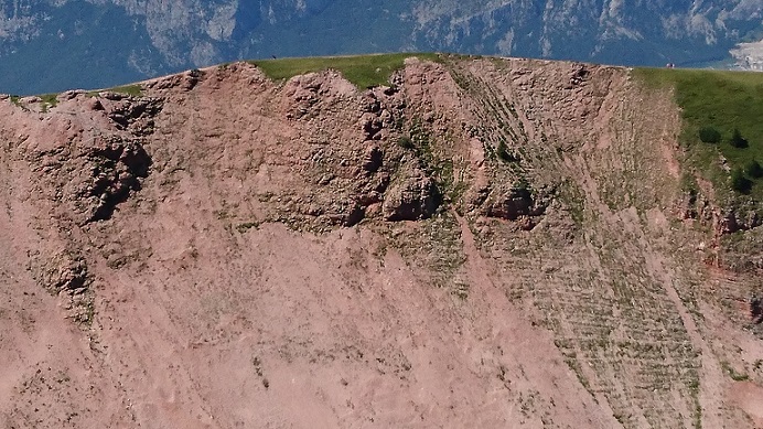
Nella parte superiore gli strati si fanno ancora più sottili, mentre i calcari si fanno più marnosi, il tetto dell’unità invece è delimitata da un livello di hardground ferrifero-fosfatico, bruno e nerastro, di qualche centimetro di spessore, il quale marca il passaggio alle formazioni successive. L’ambiente di sedimentazione è di tipo emipelagico con forti apporti terrigeni da aree settentrionali in emersione. Gli affioramenti di Scaglia raggiungono i 100 m di spessore all’interno dell’area di studio, tale complesso roccioso con il suo colore caratteristico dona un aspetto peculiare a tutta la riserva, la quale viene completamente avvolta dal rosso e dal rosa della Scaglia anche grazie ai numerosi depositi di versante, che ricoprono i fianchi della Val Mana, circondando i calcari grigio chiaro delle tre cime.
Calcare di Malcesine (Bartoniano 48,6-37,2 Ma), costituito da calcareniti nummulitiche grigio nocciola e grigio scuro, con granulometria fine in basso e via via più grossolana verso l’alto, passando così da siltiti ad areniti. 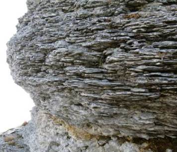
Si tratta di calcari mal stratificati, con una struttura nodulare dovuta alla presenza di noduli e globuli di calcareniti cementati e immersi in una matrice più marnosa e friabile, mentre nella parte sommitale della formazione la stratificazione appare più netta grazie a intercalazioni di livelli argillosi. La glauconite è sempre presente, anche se in quantità variabile, talvolta minima. Nella riserva il Calcare di Malcesine raggiunge lo spessore di circa 50 m e affiora alla base della cima del Cornetto e del Doss d’Abramo; tale formazione compone anche la sommità della Costa dei Cavai, dove passa il sentiero che, partendo dai pascoli della piana delle Viote, conduce alla cima del Cornetto. Sono stati eseguiti due rilievi: il primo, nonché il terzo in ordine cronologico, è stato eseguito ai piedi della sommità del Cornetto, a un’altezza di circa 2.010 m, mentre il secondo in corrispondenza di un affioramento presente lungo la cresta che collega il Doss d’Abramo al Cornetto, alla quota di circa 2.060 m s.l.m.. Nel primo caso, come dimostrato dalla foto, è estremamente evidente la stratificazione nodulare tipica del Calcare di Malcesine, inoltre se osservate da vicino le rocce appaiono ricche di fossili, tra cui le Nummuliti, le quali abbondano in questo tipo di formazione.
Calcare di Chiusole (Cuisiano 55,8-48,6 Ma), è costituito da calcari micritici organizzati in strati sottili di 10-30 cm e con interstrati marnoso-argillosi ancora più sottili; sono caratterizzati dalla presenza di Radiolari e Foraminiferi 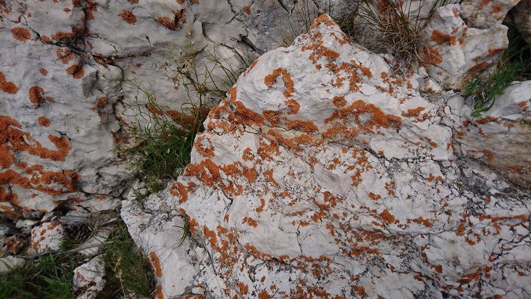
planctonici e talvolta anche di glauconite e di letti o noduli di selce. La parte superiore del complesso è dominata da calcaroi torbiditici con clasti centimetrici di Scaglia Rossa immersi in matrice arenacea, mentre la parte inferiore è quella che costituisce la sommità di Cima Verde. All’interno della riserva tale formazione raggiunge lo spessore di circa 25 m. Il Calcare di Chiusole è stato rilevato in due occasioni, la prima volta risalendo la Costa dei Cavai verso la cima del Cornetto, poco dopo esser usciti dalla mugheta, all’altezza di circa 1.970 m s.l.m. , mentre la seconda volta presso la sommità di Cima Verde, dove è stato eseguito l’ultimo rilievo.
Calcare di Nago (Priaboniano 37,2-33,9 Ma), si tratta di calcari marnosi o marne scure laminate che passano a calcareniti bioclastiche grigie alla sommità, sempre ricchi di Nummuliti, in particolare Nummulites fabianii e Discocicline. All’interno di questa formazione è possibile riconoscere tipiche sequenze regressive, caratterizzate dall’alternanza di quattro facies principali, che si alternano verticalmente in strati metrici e grossi banconi decametrici: la prima è rappresentata da calcari 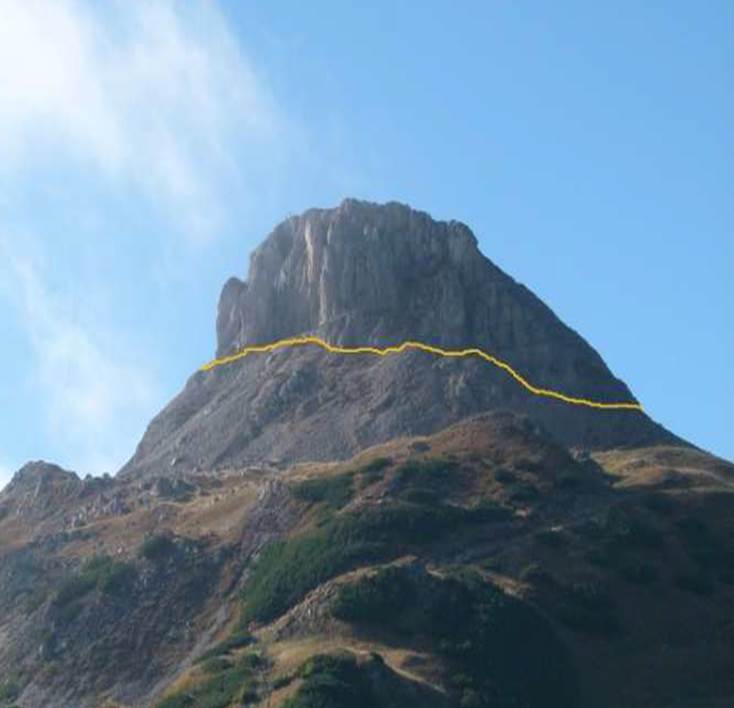
marnosi (wackestone) e marne a Melobesie e Discocicline, in strati di alcune decine di centimetri per un totale di circa 5-6 m; la seconda da biomicriti (wackestone e packstone) a Melobesie e rari coralli, in strati di 10-20 cm con intercalazioni marnose di qualche centimetro; la terza da biocalcareniti a rodoliti, macroforaminiferi e frammenti di Melobesie, in strati di circa 20-30 cm intensamente bioturbati; la quarta e ultima facies è costituita invece da calcari organogeni a coralli e altri costruttori in bancate massicce. L’ambiente sedimentario è da ricondurre a una piattaforma carbonatica a bassa profondità progradante da est a ovest. Il Calcare di Nago raggiunge lo spessore di circa 50 m, costituisce la sommità del Cornetto e del Doss d’Abramo e rappresenta la formazione più recente della serie stratigrafica locale. A proposito di tale formazione, è stata riscontrata un’anomalia nel Foglio Riva di Castellarin, in quanto il Calcare di Nago, che corrisponderebbe alla sigla E4 nella carta appena citata, non viene rappresentata e le due sommità del Cornetto e del Doss d’Abramo risultano quindi costituite solo dal Calcare di Malcesine. A dispetto di quanto indicato nella carta geologica di Castellarin, si è deciso comunque di indicare la formazione del Calcare di Nago all’apice della serie stratigrafica, come viene tra l’altro indicato in letteratura (Venzo, 2004). Sono stati eseguiti in tutto tre rilievi, uno sulla cima del Cornetto, sul versante nord-ovest, mentre gli altri due alla base del Doss d’Abramo, prima sul lato esposto a sud-ovest, poi sul lato esposto a nord, lungo il sentiero che costeggia la cima. Tra i massi e i detriti ai piedi del Cornetto, poco lontano dal sentiero è stato individuato un fossile ben conservato di un bivalve, anche se il ritrovamento è avvenuto in una zona che, secondo la carta geologica, rientra proprio nel Calcare di Malcesine, è più ragionevole pensare che tale fossile e il masso che lo conteneva appartengano al Calcare di Nago della cima sovrastante. Questo perché la disposizione caotica dei detriti fa pensare a un evento franoso che ha interessato proprio la sommità del Cornetto, come tra l’altro indicato nella carta di Castellarin.
Per loggare questa cache inviatemi le risposte ai seguenti quesiti e postate una foto di voi (o del vostro GPS)
1.) WP1: Esaminare il calcare. Che calcare è qui? Il confronto con il WP2
2.) WP2: Esaminate il calcare nei pressi della vecchia croce di legno. Che calcare è qui? Il confronto con il WP1
3.) Descrivere la Scaglia Rossa sa nemmeno. Cosa vuoi dire, perché si verifica qui in questa forma?
In seguito potete immediatamente loggare. Se qualche cosa non è corretto, vi contattiamo.

The Monte Bondone is belonging to the southern Rhaetian Alps, the territory of the Southern Alps, and rises immediately west of the city of Trento and the Adige with the complex of its four peaks: Monte Palon (2090 meters above sea level), which Valle dell’Adige, dominated overlooking the city, the Monte Cornetto (2180m),
the highest peak of the mountain, Doss d'Abramo (2,140 m) and Cima Verde (2102 m above sea level); In particular, the later represents the complex of the three peaks of Monte Bondone. The Monte Bondone is bounded on the north by the gorge of the river Vela, in the west of Rosta (1,832 m asl) overlooking the valley of the lakes and the lower Sarca borders, east of the Adige Valley, while in the southwestern ridge of Bondone -Stivo branches, which is bounded by the Loppio valley to the south. The history of this mountain begins about 200 million years ago, in the Late Triassic and Early Jurassic, as in Lias the most important phase of rifting (moving apart of continental plates within a continent) starts, which opens the Ligurian-Piedmont ocean. From the standpoint of global palaeogeography we are in a phase with a strong conciliatory character, Pangea, however, began in the Late Triassic, by forming pools between North Africa and North America, disintegrated by the rifting. The slow drift of the two continents, by the counterclockwise rotation of Africa, to ridge, which are responsible for the formation of the Ligurian-Piedmontese Ocean to the north and the central proto Atlantic in the south formed.
Geology
Scaglia Rossa (Cenomanian-Maastrichtian / Paleocene? 99.6 to 65.5 / 58.7 million years), is a formation of limestone, marl and sandstone, which has made Globotruncana and sometimes formed Inoceramus. It is red, clear and regularly laminated. Sometimes the layers are marl like the appearance of sandstone due to the abundance of planktonic Foraminiferi in the sediment.
At the top of the layers are very thin, while the limestone marl with more shares, is however limited in the upper region of a level of hard floor from iron phosphate. This layer is brown and blackish, a few centimeters thick and marks the transition to the next formation. The scope of this sedimentation is from a shore zone near with strong terrigenous components from the northern regions. The outcrops of Scaglia are in the study area up to 100 m thick. The rock complex with its characteristic color gives the whole area very special aspects, because the completely red and pink glowing Scaglia, cover the sides of the Val Mana and thanks to the numerous slope deposits surrounding the three light gray limestone peaks.
Calcare di Malcesine(bartonian 48.6 to 37.2 million years), consisting of platy limestones hazelnut and dark gray. The particle size is below very fine and continues growing upwards. They change from siltstones to sandstones.
This is a poorly stratified limestone with a nodular structure due to the presence of nodules and beads made of limestone, which is also still embedded in marl and friable matrix. In the upper part of the formation of the stratification is clearly recognizable by deposits of clay layers. Glauconite is always present, albeit in varying amounts. In this area the Malcesine limestone reaches a thickness of about 50 m, and emerges at the base of the upper part Cornetto and Doss d'Abramo. Such formation is also the peak of Costa dei Cavai and performs, starting from the flat pastures of Viote to the summit of Cornetto. Two reliefs have been investigated. In chronological order, the first and the third layer at the foot of Monte Cornetto are detected at a height of about 2,010 m, while the second layer in accordance with an indication on the Connection Ridge can be found between the Doss d'Abramo and Cornetto at a height of approximately 2,060 m. In the first relief can be find an extremely clear stratification of the typical nodular Malcesine limestone. If you look at the rocks exactly he appears rich in fossils, including Nummulites. These abound in this type of formation.
Calcare di Chiusole (55.8 to 48.6 million years ypresian), formed from the Kalkan parts of microorganisms in thin layers of 10-30 cm and made even thinner marl-clay interlayers. The limestone is characterized by the presence of radiolarians (radiolarians) and planktonic foraminifera.
Sometimes glauconite and chert nodules are embedded. The upper part of the complex is dominated by clastic sediments, which is surrounded by sandstone of Scaglia Rossa, while the bottom part also forms the summit of Cima Verde. Within this area, this formation reaches a thickness of about 25 m. The Chiusole limestone was detected in two places. Firstly, the Costa dei Cavai ascending to the top of Monte Cornetto at an altitude of about 1,970 meters above sea level. And on the other hand at the top of Cima Verde.
Calcare di Nago (37.2 to 33.9 million years priabonian) This is a limestone with marl units or at the top of dark gray laminated as bioclastischer limestone. He is always full of nummulites, especially fabianii Nummulites and Discocicline. Inside this formation, it is possible to recognize typical regressive sequences, which are characterized by the alternation of four facies, alternately vertically in metric layers and large decametrischen banks:
The first layer are marly limestones (wackestone) and marl with Melobesie and Discocicline in layers of a few tens of centimeters, for a total of about 5-6 m. The second layer of biomicrite (wackestone and pack stone) consists of Melobesie and rare coral, in layers of 10-20 cm with marl inclusions of a few centimeters. The third is a biocalcarenite consisting of rhodolites, foraminifera and fragments of Melobesien. The layers are 20-30 cm thick. The fourth and final layer is formed from coral and other organic components in the massive banks. This sedimentary rock is a flat carbonate with an orientation from east to west. The Nago-limestone reaches a thickness of about 50 m. It forms the summit of Doss d'Abramo and Cornetto and is the youngest formation of the local stratigraphy. Regarding this formation an anomaly in the map of Riva di Castellarin was found because of the limestone of Nago, which would correspond to the E4 acronym on the map, is only cited and not represented. The two upper edges of the Cornetto and Doss d'Abramo made officially only from Malcesine limestone. Based on the evidence in the geological map of Castellarin, the formation of Nago-limestone at the height of the stratigraphic was however decided to show series. The Nago-limestone was detected in all three mountain ranges. Firstly, on the northwest edge on the top of Cornetto, while the other two bodies are found at the base of Doss d'Abramo (on the south west side and on the north side along the hiking trail). Among the boulders and scree at the foot of Cornetto, not far from the way a well-preserved fossil of a shell was found, although the discovery was made in an area that belongs to the geological map, directly to Malcesine limestone. Therefore, it is more than reasonable to think that this fossil and rock overlying is attributable to the Nago-limestone. The chaotic arrangement of debris creates a landslide near the tip of the cornetto is concerned, containing, inter alia in the Castellarin card.
To log this cache, go to this location and answer the following questions. Then post a photo of you at the location to your log. Of course, if you do not want to appear in the photo, a personal item in the photo is enough proof of your presence. (According to the Earthcache Guidelines, photo-proofing has been required since June 2019.)
1.) WP1: Examine the limestone. Which one is here? Comparisons with the WP2
2.) WP2: Examine the limestone near the old wooden cross. Which one is here? Comparisons with the WP1
3.) Describe the Scaglia rossa even know. What do you mean, why it occurs here in this form?
After that you can give your log directly. If anything is not ok, we will contact you.

Der Monte Bondone liegt in den südlichen Rätischen Alpen, dem Herrschaftsgebiet der südlichen Alpen angehörend, und erhebt sich unmittelbar westlich von der Stadt Trento und der Etsch mit dem Komplex aus ihren vier Gipfeln: Monte Palon (2090 m ü.NN) , der das Etschtal mit Blick auf die Stadt dominiert, die Monte Cornetto (2180 m),
dem höchsten Gipfel des Gebirges, Doss d'Abramo (2.140 m) und Cima Verde (2102 m über dem Meeresspiegel) ; Insbesondere letzterer repräsentiert den Komplex der Drei Gipfel des Monte Bondone. Der Monte Bondone wird im Norden durch die Schlucht des Flusses Vela begrenzt, im Westen vom Rosta (1.832 m ü.NN) mit Blick auf das Tal der Seen und der unteren Sarca, grenzt östlich an das Etschtal, während im Südwesten der Bergrücken des Bondone-Stivo abzweigt, der durch das Loppio-Tal im Süden begrenzt wird. Die Geschichte dieses Berges beginnt etwa 200 Millionen Jahren, im späten Trias und der frühen Jura, als im Lias die wichtigste Phase des Rifting (Auseinanderrücken von kontinentalen Platten innerhalb eines Kontinents) beginnt, das den ligurische-piemontesischen Ozean öffnet. Vom Standpunkt der globalen Paläogeographie befinden wir uns in einer Phase mit einem starken versöhnlichen Charakter, Pangea, hingegen, begann bereits in der späten Trias, durch Bildung von Becken zwischen Nordafrika und Nordamerika, durch das Rifting zerfallen. Durch das langsame Driften der beiden Kontinente, durch die Drehung gegen den Uhrzeigersinn von Afrika, bildeten sich Bergrücken, die für die Formation des ligurische-piemontischen Ozean im Norden und den zentralen Protoatlantik im Süden verantwortlich sind.
Geologie
Scaglia Rossa (Cenomanian-Maastrichtian / Paläozän? 99,6-65,5 / 58,7 Mio Jahre), ist eine Formation aus Kalkstein, Mergel und Sandstein, die sich aus Globotruncana und manchmal Inoceramus gebildet hat. Sie ist rot, klar und regelmäßig laminiert. Manchmal sind die Schichten mergelartig mit dem Aussehen von Sandstein aufgrund der Fülle von planktonischen Foraminiferi im Sediment.
Im oberen Teil sind die Schichten noch sehr dünn, während der Kalkstein mit mehr Mergelanteilen, hingegen im oberen Bereich von einem Niveau von Hartboden aus Eisen-Phosphat begrenzt wird. Diese Schicht ist braun und schwärzlich, wenige Zentimeter dick und markiert den Übergang in die nächste Formation. Der Bereich dieser Sedimentation stammt von einer Ufer nahen Zone mit starken terrigenen Anteilen aus den nördlichen Gebieten. Die Aufschlüsse der Scaglia sind im Untersuchungsgebiet bis zu 100 m dick. Der Felskomplex mit seiner charakteristischen Farbe verleiht dem gesamten Gebiet ganz besondere Aspekte, da die vollständig rot und rosa leuchtende Scaglia, die Seiten des Val Mana abdecken und Dank der zahlreiche Hang Ablagerungen die drei hellgrauen Kalkgipfel umgibt.
Calcare di Malcesine (Bartonium 48,6-37,2 Mio Jahre), besteht aus plättchenförmigen Kalksteinen haselnussgrau und dunkelgrau. Die Partikelgröße ist unten sehr fein und wird nach oben hin immer grösser. Sie verändern sich von Siltsteinen zu Sandsteine.
Es handelt sich hier um einen schlecht geschichteten Kalkstein, mit einer Knötchen-Struktur, aufgrund des Vorhandenseins von Knötchen und Kügelchen aus Kalkstein, die zudem noch in Mergel und einer bröckeligen Matrix eingebettet ist. Im oberen Teil ist die Formation der Schichtung klarer durch Einlagerungen von tonigen Ebenen erkennbar. Glaukonit ist immer vorhanden, wenn auch in unterschiedlichen Mengen. In diesem Gebiet erreicht der Malcesine-Kalkstein eine Dicke von etwa 50 m und tritt an der Basis des oberen Teils Cornetto und Doss d'Abramo hervor. Eine solche Formation bildet auch die Spitze des Costa dei Cavai und führt, ausgehend von den flachen Weiden von Viote zum Gipfel des Cornetto. Zwei Reliefs wurden untersucht. In chronologischer Reihenfolge sind die erste und die dritte Schicht am Fuße des Monte Cornetto auf einer einer Höhe von etwa 2.010 m nachgewiesen, während die zweite Schicht in Übereinstimmung mit einem Aufschluss auf dem Verbindungsgrat zwischen dem Doss d'Abramo und dem Cornetto in einer Höhe von rund 2060 m zu finden ist. Im ersten Relief ist eine extrem klare Schichtung des typischen knotige Malcesine-Kalkstein zu finden. Wenn man den Felsen genau betrachtet, erscheint er reich an Fossilien, darunter Nummulites. Diese gibt es zuhauf in dieser Art von Formation.
Calcare di Chiusole (Ypresium 55,8-48,6 Mio. Jahre), bildete sich aus den Kalkanteilen von Mikroorganismen in dünnen Schichten von 10-30 cm und aus noch dünneren mergel-lehmigen Zwischenschichten. Der Kalkstein ist durch die Anwesenheit von Radiolarien ( Strahlentierchen) und Planktonforaminiferen gekennzeichnet.
Manchmal sind Glaukonit und Kieselschiefer-Knötchen eingebettet. Der obere Teil des Komplexes wird durch klastische Sedimente dominiert, die vom Sandstein der Scaglia Rossa umgeben wird, während der untere Teil auch den Gipfel des Cima Verde bildet. Innerhalb dieses Gebietes erreicht diese Formation eine Dicke von etwa 25 m. Der Chiusole-Kalkstein wurde an zwei Stellen erkannt. Zum Einen der Costa dei Cavai aufsteigend zur Spitze des Monte Cornetto auf einer Höhe von etwa 1.970 m über NN. Und zum Anderen an der Spitze der Cima Verde.
Calcare di Nago (Priabonium 37,2-33,9 Mio Jahre) Hierbei handelt es sich um einen Kalkstein mit Mergelanteilen oder im oberen Bereich dunkel laminiert als grauer bioclastischer Kalkstein. Er ist immer reich an Nummuliten, insbesondere Nummulites fabianii und Discocicline. Im Innern dieser Formation ist es möglich, typische regressive Sequenzen zu erkennen, die durch den Wechsel von vier Fazies gekennzeichnet sind, abwechselnd vertikal in metrischen Schichten und großen decametrischen Bänke:
Die erste Schicht sind Mergelkalke (wackestone) und Mergel mit Melobesie und Discocicline in Schichten von wenigen Dezimetern, für insgesamt etwa 5-6 m. Die zweite Schicht aus Biomikrit (wackestone und packstone) besteht aus Melobesie und seltene Korallen, in Schichten von 10-20 cm mit Mergeleinschlüssen von einigen Zentimetern. Die dritte ist ein Biocalcarenit bestehend aus Rhodoliten, Foraminiferen und Fragmente von Melobesien. Die Schichten sind 20-30 cm dick. Die vierte und letzte Schicht wird aus Korallen und anderen organischen Teilen in den massiven Bänken gebildet. Dieses Sedimentgestein ist eine flache Karbonatplattform mit einer Ausrichtung von Ost nach West. Der Nago-Kalkstein erreicht eine Dicke von etwa 50 m. Er bildet den Gipfel von Doss d'Abramo und Cornetto und ist die jüngste Bildung der lokalen Stratigraphie. In Bezug auf diese Formation wurde eine Anomalie in der Karte von Riva di Castellarin gefunden, weil der Kalkstein von Nago, die dem Akronym E4 auf der Karte entsprechen würde, nur zitiert und nicht vertreten ist. Die beiden oberen Ränder des Cornetto und Doss d'Abramo bestehen offiziell nur aus dem Malcesine-Kalkstein. Aufgrund der Hinweise in der geologischen Karte von Castellarin, wurde allerdings beschlossen, die Bildung von Nago-Kalkstein auf der Höhe der stratigraphischen Serie mit anzuzeigen. Der Nago-Kalkstein wurde in allen drei Bergketten nachgewiesen. Zum einen an der nordwestlichen Flanke auf dem Gipfel des Cornetto, während die anderen beiden Stellen an der Basis des Doss d’Abramo zu finden sind (auf der süd-westlichen Seite und auf der nördlichen Seite entlang des Wanderweges). Unter den Felsbrocken und Geröll am Fuße des Cornetto, nicht weit vom Weg wurde ein gut erhaltenes Fossil einer Muschel gefunden, obwohl die Entdeckung in einem Gebiet gemacht wurde, das nach der geologischen Karte, direkt zum Malcesine-Kalkstein gehört. Daher ist es mehr als vernünftig zu denken, dass dieses Fossil und das darüber liegende Gestein dem Nago-Kalkstein zuzuordnen ist. Die chaotische Anordnung von Schutt legt einen Erdrutsch nahe Das die Spitze des Cornetto betroffen ist, wird unter anderem in der Castellarin-Karte angegeben.
Um diesen Cache zu loggen, begib dich zu dieser Location und beantworte nachfolgende Fragen. Anschließend postet zu eurem Log bitte noch ein Foto von euch an der Location. Wenn ihr selbst nicht auf dem Foto erscheinen wollt, reicht natürlich auch ein persönlicher Gegenstand auf dem Foto als Beweis eurer Anwesenheit. (Laut Earthcache Guidelines ist die Forderung eines Fotobeweises seit Juni 2019 wieder erlaubt.)
1.) WP1: Untersuche den Kalkstein. Um welchen handelt es sich hier? Vergleiche mit dem WP2
2.) WP2: Untersuche den Kalkstein in der Nähe des alten Holzkreuzes. Um welchen handelt es sich hier? Vergleiche mit dem WP1
3.) Beschreibe den Scaglia rossa einmal genau. Was meinst du, warum er hier in dieser Form vorkommt?
Danach könnt Ihr sofort loggen. Wenn irgendetwas nicht in Ordnung sein sollte, melden wir uns.
l'indice delle fonti:
• FrancescaBussola_Relazione
• Spektrum.de
• Fotos intrinsecamente