
The Maryland Geocaching Society welcomes you to the 2017 edition of Cache Across Maryland! This is one of eleven geocaches placed throughout the ‘Old Line State’ in locations specifically chosen to showcase its diverse beauty. From the mountains of Western Maryland to the wetlands of the Eastern Shore, CAM 2017 will demonstrate that Maryland truly is ‘America in Miniature’.
Each Cache Across Maryland 2017 geocache contains a code which you will use to determine the location of the CAM 2017 Picnic to be held on May 6th. The code can be found on the inside of the cache container and on the inside front cover of the logbook. Don't forget to record this code! Any geocacher who has completed TEN of the eleven CAM 2017 geocaches and attends the CAM Picnic on May 6th will receive a Certificate of Completion and a CAM 2017 Geocoin. We hope you enjoy a very special CAM 2017!
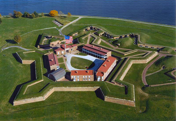
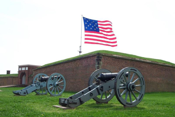
Fort McHenry National Monument and Historic Shrine
Located in Baltimore, Maryland, Fort McHenry is a historical American coastal star-shaped fort best known for its role in the War of 1812, when it successfully defended Baltimore Harbor from an attack by the British navy from the Chesapeake Bay on September 13–14, 1814. It was first built in 1798 and was used continuously by U.S. armed forces through World War I and by the Coast Guard in World War II. It was designated a national park in 1925, and in 1939 was redesignated a ‘National Monument and Historic Shrine’.
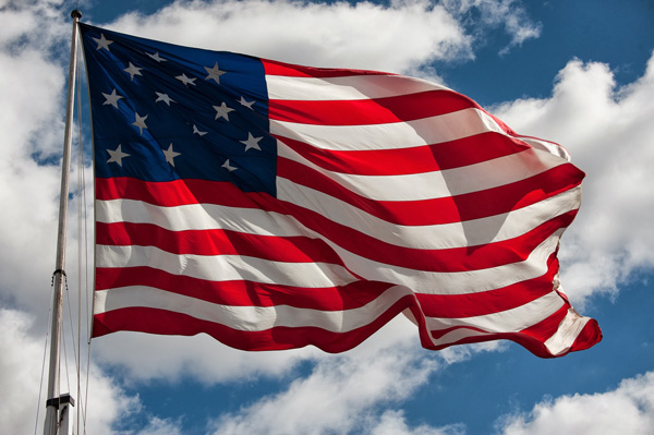
During the War of 1812 a storm flag (17 by 25 feet) was flown over Fort McHenry during the bombardment. It was replaced early on the morning of September 14, 1814 with a larger garrison flag (30 by 42 feet). The larger flag signaled American victory over the British in the Battle of Baltimore. The sight of the ensign inspired Francis Scott Key to write the poem ‘Defence of Fort M'Henry’ that was later set to the tune ‘To Anacreon in Heaven’ and become known as the ‘Star Spangled Banner’, the national anthem of the United States.
Fort McHenry was built on the site of the former Fort Whetstone, which had defended Baltimore from 1776 to 1797. Fort Whetstone stood on Whetstone Point (today's residential and industrial area of Locust Point) peninsula, which juts into the opening of Baltimore Harbor between the Basin (today's Inner Harbor) and Northwest branch on the north side and the Middle and Ferry (now Southern) branches of the Patapsco River on the south side.
Frenchman Jean Foncin designed the fort in 1798, and it was built between 1798 and 1800. The new fort's purpose was to improve the defenses of the increasingly important Port of Baltimore from future enemy attacks. The new fort was constructed in the form of a five-pointed star surrounded by a dry moat — a deep, broad trench. The moat would serve as a shelter from which infantry might defend the fort from a land attack. In case of such an attack on this first line of defense, each point, or bastion could provide a crossfire of cannon and small arms fire.
Fort McHenry was named after early American statesman James McHenry (1753–1816), a Scots-Irish immigrant and surgeon-soldier. He was a delegate to the Continental Congress from Maryland and a signer of the United States Constitution. Afterwards, he was appointed United States Secretary of War, serving under presidents Presidents George Washington and John Adams.
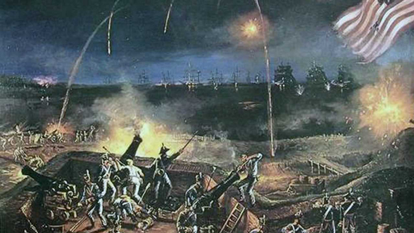
Beginning at 6am on 13 September 1814, British warships under the command of Vice Admiral Alexander Cochrane continuously bombarded Fort McHenry for 25 hours. The American defenders had 18-, 24- and 32-pounder cannons. The British guns had a range of 2 miles, and the British rockets had a 1.75-mile range, but neither guns nor rockets were accurate. The British ships were unable to pass Fort McHenry and penetrate Baltimore Harbor because of its defenses, including a chain of 22 sunken ships, and the American cannons. The British vessels were only able to fire their rockets and mortars at the fort at the weapons' maximum range. The poor accuracy on both sides resulted in very little damage to either side before the British, having depleted their ammunition, ceased their attack on the morning of 14 September. Thus the naval part of the British invasion of Baltimore had been repulsed. Only one British warship, a bomb vessel, received a direct hit from the fort's return fire, which wounded one crewman.
The Americans, under the command of Major George Armistead, lost four killed, including one African-American soldier, Private William Williams, and a woman who was cut in half by a bomb as she carried supplies to the troops, and 24 wounded. At one point during the bombardment, a bomb crashed through the fort's powder magazine. Fortunately for the defenders, either the rain extinguished the fuse or the bomb was a dud.
Francis Scott Key, a Washington lawyer who had come to Baltimore to negotiate the release of Dr. William Beanes, a civilian prisoner of war, witnessed the bombardment from a nearby truce ship. An oversized American flag had been sewn by Mary Pickersgill for $405.90 in anticipation of the British attack on the fort. When Key saw the flag emerge intact in the dawn of September 14, he was so moved that he began that morning to compose the poem ‘Defence of Fort M'Henry’ which would later be renamed ‘The Star-Spangled Banner’ and become the United States' national anthem.
During the American Civil War, the area where Fort McHenry sits served as a military prison, confining both Confederate soldiers, as well as a large number of Maryland political figures who were suspected of being Confederate sympathizers. The imprisoned included newly elected Baltimore Mayor, the city council, the new police commissioner, members of the Maryland General Assembly, and several newspaper editors and owners. Francis Scott Key's grandson, Francis Key Howard, was one of these political detainees. In 1861, after President Abraham Lincoln delegated limited authority to the Army to suspend habeas corpus in Maryland, a drama unfolded involving the night arrest of John Merryman at his Cockeysville home by Union troops, his imprisonment in the fort, and the upholding of his demand for a writ of habeas corpus for release by Chief Justice Roger B. Taney. This resulted in a famous and controversial federal court case, the decision of which remains contested to this day. Around the same time, Fort McHenry also served to train artillery which is the origin of the Rodman guns presently located and displayed at the fort.
During World War I, an additional hundred-odd buildings were built on the land surrounding the fort in order to convert the entire facility into an enormous U.S. Army hospital for the treatment of troops returning from the European conflict. Only a few of these buildings remain, while the original fort has been preserved and restored to essentially its condition during the War of 1812. Fort McHenry served as a Coast Guard base during World War II.
The fort was made a national park in 1925; on August 11, 1939, it was redesignated a ‘National Monument and Historic Shrine’, the only such doubly designated place in the United States. It was placed on the National Register of Historic Places on October 15, 1966. It has become national tradition that when a new flag is designed it first flies over Fort McHenry. The first official 49- and 50-star American flags were flown over the fort and are still located on the premises.
The Fort has become a vital center of recreation for the Baltimore locals as well as a prominent tourist destination. Thousands of visitors come each year to see the ‘Birthplace of the Star Spangled Banner’. Every September, the City of Baltimore commemorates Defenders Day in honor of the Battle of Baltimore. It is the biggest celebration of the year at the Fort, accompanied by a weekend of programs, events, and fireworks. The United States Code presently authorizes Fort McHenry's closure to the public in the event of a national emergency for use by the military for the duration of such an emergency.

The flag that flew over Fort McHenry, the Star Spangled Banner Flag, has deteriorated to an extremely fragile condition. After undergoing restoration at the National Museum of American History, it is now on display there in a special exhibit that allows it to lie at a slight angle in dim light.
Admission
In order to complete this geocache, adults 16 and older will need to pay a $15 fee in the Visitor Center for entrance to the historic area. (Children 15 and younger can enter for free.) This fee provides the visitor with a 7-day entrance permit to Fort McHenry. Holders of NPS Annual or Lifetime Passes are not required to pay the fee.
Admission will be FREE on the two National Parks Fee-Free weekends which fall during CAM 2017: April 15–16 and April 22–23.
Unsolicited advice: If you can spare an additional 10 minutes, be sure to watch the movie in the Visitor Center which plays every half-hour. It recounts the story of Fort McHenry and the Star-Spangled Banner, and it will really set the mood for your visit to the fort. The finale alone is worth the price of admission.
The Geocache
This geocache is not located at the listed coordinates. You will visit several locations within the Star Fort to determine the coordinates to the final location. You will also determine the combination to a lock you will need to open to access the container. Additional waypoints have been provided for all the locations. A flashlight might be helpful for Location 2.
1. Sally Port (N39° 15.807', W076° 34.772')
Enter the Star Fort by walking up the wooden ramp to the Sally Port. About midway through the port you will see an opening in the left wall bearing a sign: ‘LOW CEILING WATCH YOUR HEAD’. Heed this advice as you enter and descend the stairs to the ‘Bombproofs’ interpretive sign. Find the floorplan on the right side of the sign and count the airshafts. (Don't miss the one at the top.)
- A = # of airshafts, minus 2
2. Jail (N39° 15.802', W076° 34.777')
Climb back up the stairs (mind your head!) and continue through the port. As you emerge into the Parade, turn left and enter the first door on your left. Once inside the room, you will see an archway to your right. Walk through, turn left, and follow the steps up to the farthest jail cell. Look inside for the sign on the cell wall. (A flashlight might be helpful here.) On the sign, find the lower-left paragraph containing 10 lines of text.
- B = line # beginning with ‘a spy’
Stages 3 through 9 will take you on a clockwise tour of the various buildings within the fort. Each room you visit will provide an answer to a stage of the puzzle. Some buildings contain more than one room, and you will only be visiting the ground level rooms. When counting door numbers, always count from left to right.
3. No. 2 Soldiers' Barracks: Door 1 (N39° 15.793', W076° 34.781')
The first building, No. 2 Soldiers' Barracks, contains three rooms. Enter through the first door. Locate the ‘Semper Paratus’ sign, then examine the short wave radio beneath it.
- C = the rightmost digit under the word ‘WAVE’
4. No. 2 Soldiers' Barracks: Door 2 (N39° 15.789', W076° 34.786')
Proceed to the second room and look for cannons (real cannons, not photographs).
- D = # of cannons in the room
5. No. 2 Soldiers' Barracks: Door 3 (N39° 15.785', W076° 34.790')
In the third room, find the sign picturing a drummer and two soldiers and consult the chart at the bottom-left.
- E = the sum of the ages of the Pennsylvanian and the Baker, minus 50
6. No. 1 Soldiers' Barracks: Door 2 (N39° 15.786', W076° 34.802')
Proceed to the next building, No. 1 Soldiers' Barracks. (Door 1 is closed to the general public; doors 3 and 4 are restrooms.) Enter the second room. Against the far wall stands a tall display case containing a cross-section of buried items. Find the Clothespin and the British Coin, and note the 3rd digit in each item's year. (example: ##?#, ##?#)
- F = the sum of those two digits (?+?)
7. Officers' Quarters: Door 2 (N39° 15.796', W076° 34.811')
Proceed to the next building and enter through the second door. (Doors 1 and 3 are closed to the general public.) Beneath the middle display window is a photograph of a dining table set with food. Three plates of oysters are pictured (not including the partial one at the top). Two of those plates contain the same number of oysters, while the third plate contains a different amount.
- G = # of oysters on the third plate
8. Powder Magazine (N39° 15.806', W076° 34.812')
Enter the building with the arched roof. Once inside you should notice a wooden ladder leaning against the far wall.
- H = # of rungs on the ladder
9. Commanding Officer's Quarters (N39° 15.807', W076° 34.803')
The Commanding Officer's Quarters comprises five rooms (including the antechamber), all accessed from inside the building. In the third room, find the large American flag display honoring Mary Pickersgill. Four of the red stripes contain rotating segments. Rotate the topmost movable segment.
- W = # of British eyewitnesses
Continue through the Commanding Officer's bedroom to leave the building, then find your way around the side of the building to the flagpole.
10. Flagpole (N39° 15.804', W076° 34.783')
Locate the interpretive sign near the flagpole.
- X = the first digit appearing on the sign
11. Ravelin Magazine (N39° 15.812', W076° 34.759')
As you exit the Star Fort through the Sally Port, you will see an angled wall with two gated archways directly in front of you. Enter through either gateway and find the interpretive sign at the bottom of the stairs. In the lower-left corner of the sign is an illustration of powder kegs stacked upon two shelves.
- Y = # of powder kegs bearing the word ‘CANNON’
12. Stone Tablet (N39° 15.824', W076° 34.772')
Upon exiting the Ravelin Magazine, turn right and follow the path. Affixed to the fort wall you will find a stone tablet bearing a bronze shield.
- Z = the most frequently occurring digit on the bronze shield
Final
The checksum of A+B+C+D+E+F = 29
The checksum of G+H+W+X+Y+Z = 26
- The geocache is located at N39° 1A.BCD', W076° 3E.FGH'
- The lock combination is WXYZ
To access the final, follow the walkway from the Star Fort to the paved walking loop which follows the water's edge.
The park is open from 9am to 5pm, however the Star Fort and Visitor Center close at 4.45pm. The park is closed Thanksgiving, Christmas, and New Year's days.
The Maryland Geocaching Society extends its thanks to the National Park Service for allowing us to place a geocache at this very special National Monument and Historic Shrine. Geocaches may only be placed on National Park Property at the direction of National Park Service staff.