Insel Elafonis
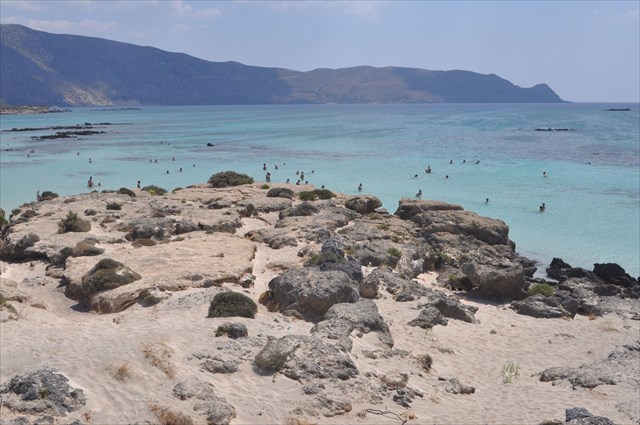
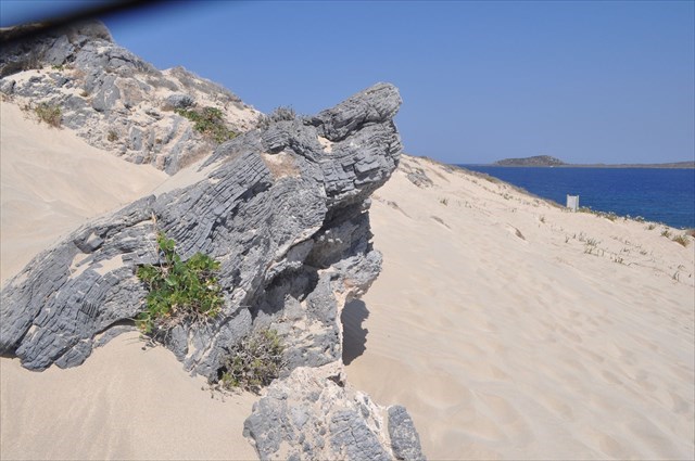
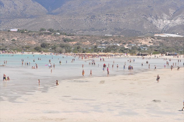
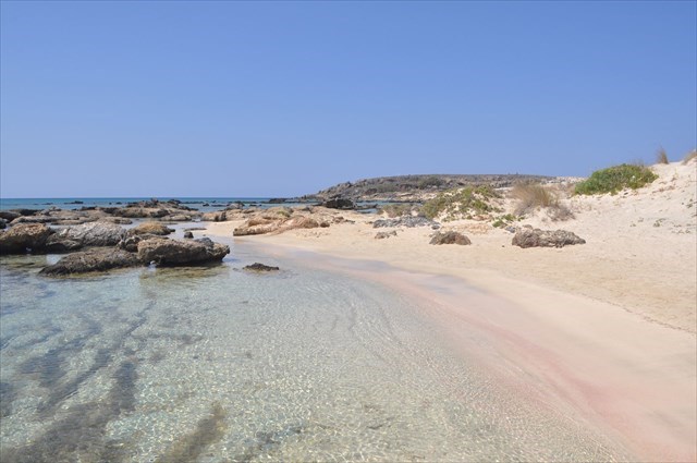
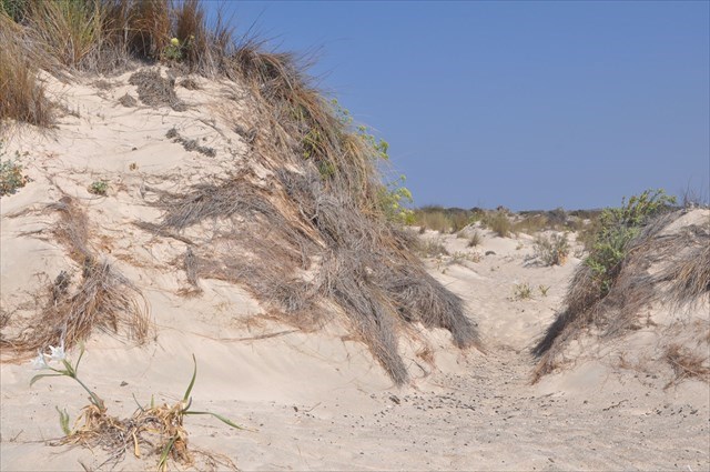
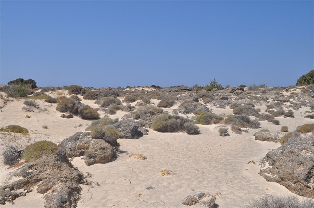
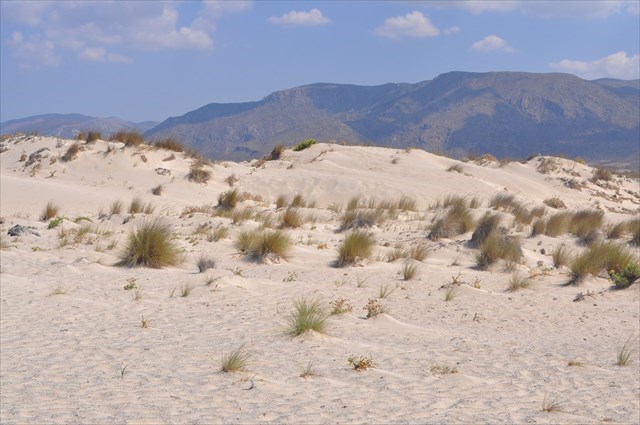
Insel Elafonisi and its beach are in the south of Crete. The entire area (Elafonissi Island, dunes and lagoon) is located in the Natura 2000 protected area. It is interesting from a geological point of view. The place provides excellent observation of aeolian processes. The formation of dunes. In a small area, we can see Morphology of coastal dunes and the formation of a lagoon. (Over time, she will be annihilated by overlapping layers of sand. )They are built of calcareous sands, calcite with a small silicon dopant derived from living organisms. Elafonisi was an island during a long period of time, and processes such as rising of the seabed, erosion of limestone rocks, the supply of rock material from the sea, and land were connected to the mainland. Dune morphology is dependent on sea currents and winds. You can see the erosion of limestone rocks, which take on a variety of whites. Sand creates dunes of different heights, different runs, and even flat surfaces. Dunes cover a wide variety of vegetation. In the center of the island there are sedimentary rocks, which often cover the sand. (Secondary dunes area). Similar formations are seen in the coastal zone, where the wind and sand grains are degraded. Wind called Sirocco. (Wind from Africa). Winding winds have a huge impact on the appearance of this area. These factors shape the landscape.. This makes the northern and southern Elafonisios coastlines. Sea currents and winds blowing from the south have cleared the barrier of shallow water. The strength of wind and sea currents affecting the Elafonisi coast leads to the creation of dunes on the south side. The north and west coasts look different. There are barriers in the form of submarine sedimentary rocks. It produces strong sea currents that deposit sand grains from the seabed. In addition, in the spring months, the winds catch sand from the Sahara. Transporting it at considerable distances. Calcareous sand, sand which is primarily composed of calcium carbonate, and elsewhere is composed of debris from once living marine organisms. When these plants and animals used calcium carbonate, {CaCO3}or Silicon dioxide {SiO2}. When the organisms died, these pieces became part of the sand beach. This sand is transferred to the surface of the land.
Coastal dunes
Coastal dunes are a ridge, or a series of ridges, that form at the rear of a beach and differ from most other constructional coastal landforms in that they are formed by the movement of air (aeolian transport) rather than by tidal, wave, or current action. Initiation of aeolian transportation is controlled by wind velocity, the characteristics of sediments, beach morphology, moisture content, and the degree of roughness elements present (driftwood and vegetation). The movement of sediment into the back beach environment often results in the formation of coastal dunes.
Morphology of coastal dunes
Depending on the characteristics and availability of the sediment supply, dominant wind velocity and direction, moisture and vegetation present, and the geomorphology of the nearshore and beach face, dunes of various size and morphology are formed (for processes on aeolian transports.). Sand deposition, accretion, and erosion within the coastal environment result in the development of a variety of dune morphologies; however, a general classification into primary and secondary dunes can be made.
Primary dunes
are composed of sand blown directly from the beach face (active beach), whereas secondary dunes develop following the subsequent modification of primary dunes. The availability of sediment for dune building is a function of sediment transport in the nearshore environment. The amount of sediment supplied from the beach to the back-beach environment is dependant on wind and wave power, tidal range, and beach type.. In general, sediment is transported landward via wave motion and swash to the foreshore, beachface, and backshore environments during periods of beach accretion. During low tides this sediment dries and is susceptible to aeolian (wind-blown) transportation. In addition to an abundant sediment supply there are numerous factors that control the availability of sediment to the backshore environment, the main ones being wind velocity and direction, moisture content, vegetation and beach morphology. Vegetation is a significant controlling factor influencing the formation and morphology of coastal dunes .
The moisture content of the sand controls the cohesion between individual grains. An increase in moisture content will significantly increase the cohesion of the sediment and reduce the capacity of the wind to initiate transportation. Accordingly, deflation (wind erosion) normally only occurs down to the level of damp sand, some vertical distance above the water table. As the water-table in permeable sand forms a horizontal or very gently sloping surface, deflation basins within dunefields, and the sand plains at the rear of transgressive dunes or between dune ridges, are usually relatively flat - sedimentary rock, loose, composed of unbound mineral binder, mainly quartz. The grain size varies depending on the accepted classification from 0.05 or 0.063 to 2 mm, the density of quartz sand grains is about 2.62 g / cm3.
A lagoon
is a shallow body of water separated from a larger body of water by barrier islands or reefs. Lagoons are commonly divided into coastal lagoons and atoll lagoons. They have also been identified as occurring on mixed-sand and gravel coastlines.
.
Answers send via my profile and then log your find. If anything is wrong I will contact you.
*** Questions. ***
1 / What type of dunes, we see just behind the beach?
2 / Go to the opposite shore of the island. (North direction). Can you see this type of dunes? Yes? No? . Justify your answer.
3 / Review the height of the dunes shaft and its direction?
4/ As we call the process the wind's ability to shape the surface of the Earth.
Wikipedia, Internet, Photos of my property.
If you visited my EarthCache, I prepared a special souvenir that you can paste into your profile:
Jeśli odwiedziłeś mojego EarthCache to przygotowałem specjalnie pamiatkę, którą możesz wkleić do swojego profilu:
Code to paste , Kod do wklejenia:
<p align="center"><a href="https://coord.info/GC77JFT" target="_blank"><img src="https://s3.amazonaws.com/gs-geo-images/56a143d5-75ad-4f13-aee4-d22c9e40a193_l.png" title="EarthCache by niuton" width="350" height="222" alt name="ktn" /></a></p>

<p align="center"><a href="https://coord.info/GC7PYHQ" target="_blank"><img src="https://s3.amazonaws.com/gs-geo-images/56a143d5-75ad-4f13-aee4-d22c9e40a193_l.png" title="EarthCache by niuton" width="350" height="222" alt name="ktn" /></a></p>