 Historia
På Warg gårdsplan i Hästbacka by finns en gravkällare som torde härstamma från 1500-1600-talet. Före de fått eget bönehus i Terjärv förvarades liken i graven fram till vintern. Endast på vintern kunde man föra liken till Kronoby eftersom det på sommaren bara fanns gångstigar mellan orterna och inga vägar som var farbara med kärra.
(Källor: Terjärv hembygdsförening, m.fl.)
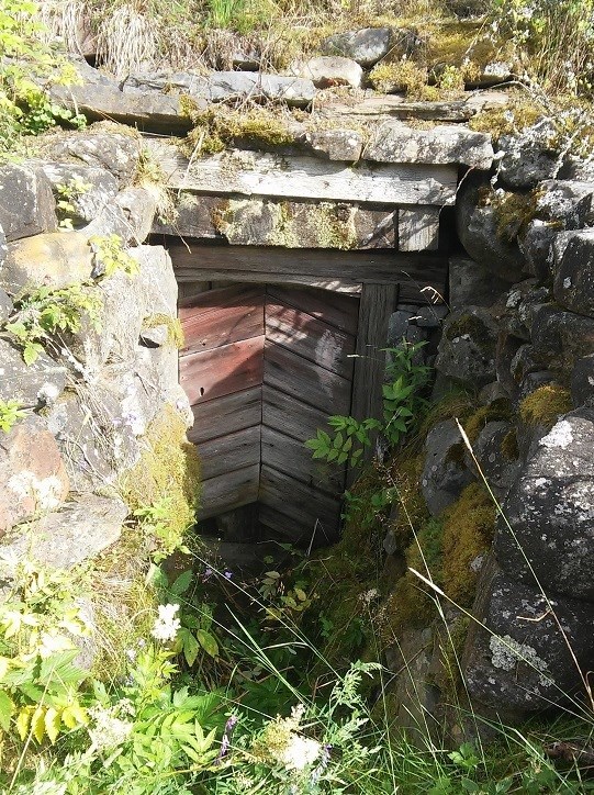
Källaren finns inne i en gårdsgrupp och bör därför inte besökas utan markägarens tillstånd.
Cacheinstruktioner
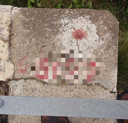
Från startpunkten ser du huset på vars gårdsplan graven finns. För att hitta cachen skall du först hitta en hödjfixpunkt som finns på ett av brofästena till bron du står på. Bredvid punkten, i betongen finns 5 rödmålade siffror. Du behöver inte bry dig om första siffran men de fyra följande siffrorna är ABCD
Cachen hittas på följande plats:
N 63° 33.(BCD-54)
E 023° 2(D-1).(ABC-161)
Cacheserien innehåller en bonuscache, kom ihåg att anteckna bonuscachens uppgifter!
Medeltid i samtid
Leader-projektet "
Medeltid i samtid. Kunskapsöverföring om österbottningarna och deras äldre historia" genomförs i de 14 tvåspråkiga österbottniska kommunerna under perioden april 2016–mars 2018.
”Medeltid i samtid” lyfter fram Österbottens äldre historia, från 1300-talet till 1600-talets mitt*, synliggör den och arbetar med metoder för ökad kunskapsöverföring. Målsättningen är att öka medvetenheten om den äldre historien och om hur den kan användas som resurs i dag.
* = vissa geocacher är gjorda kring händelser som skedde i skiftet mellan 1600 och 1700 talet.
 Historia
Hästbackan kylässä Wargin talon pihalla on hautakellari joka lienee 1500- tai 1600-luvulta. Ennen kuin Teerijärven asukkaat saivat oman rukoushuoneen, ruumiit säilytettiin hautakellarissa talveen asti. Vain talvisin pystyttiin nimittäin viemään ruumiit Kruunupyyhyn. Kesäisin oli käytössä pelkkiä kävelypolkuja kylien välillä, eikä kärryillä kulkukelpoisia teitä ollut olemassakaan.
(Lähteet: Teerijärven kotiseutuyhdistys ym.)
Kellari sijaitsee yksityisessä pihapiirissä eikä sitä siksi voi käydä katsomassa ilman maanomistajan lupaa.
Geokätkön ohjeet
Lähtöpisteestä näet talon jonka pihalla hautakellari sijaitsee. Löytääksesi kätkön sinun pitää ensin löytää korkeuskiintopiste. Piste sijaitsee sillanpäässä juuri sillä sillalla, jolla parhaillaan seisot. Betonissa, pisteen vieressä, on 5 punaista numeroa. Älä välitä ensimmäisestä numerosta, mutta seuraavat neljä numeroa ovat ABCD.
Kätkön koordinaatit ovat:
N 63° 33.(BCD-54)
E 023° 2(D-1).(ABC-161)
Kätkösarjaan kuuluu bonuskätkö, joten muistathan kirjoittaa ylös bonuskätkön tiedot!
Medeltid i samtid
Leader-hanke ”
Medeltid i samtid. Kunskapsöverföring om österbottningarna och deras äldre historia” toteutetaan 14 kaksikielisessä pohjalaiskunnassa huhtikuusta 2016 maaliskuuhun 2018.
”Medeltid i samtid” (= ”Keskiaika nykyajassa”) nostaa esille Pohjanmaan varhaishistorian 1300 -luvulta 1600 -luvun puoleenväliin* ja kehittää uusia menetelmiä keskiajan tuntemuksen siirtämiseksi. Tavoitteena on lisätä tietoisuutta alueen varhaishistoriasta ja siitä, miten sitä voidaan käyttää voimavarana nykypäivän hankkeissa.
*Muutamat geokätköt liittyvät 1600- ja 1700 -lukujen vaihteen tapahtumiin.
 History
In the Warg courtyard in Hästbacka village there is a tomb dating back probably to the 16th or 17th century. Before there was a chapel in the village of Terjärv, the deceased were temporarily kept in the tomb, awaiting burial, until winter. Since there were no roads, only footpaths, connecting the villages, it was impossible to transport the dead to the cemetery during summer. Therefore the dead were temporarily stored in the tomb.
(Sources: Local History Association of Terjärv and others)
The tomb is on privately owned land, in a courtyard, and should therefore not be visited without the landowner’s permission.
Geocache instructions:
At the starting location, you can see the house in which courtyard the tomb is. In order to find the cache, you first need to find a fixed altitude point on one of the abutments of the bridge you are standing on. Next to the fixed altitude point, there are five numbers painted on the concrete. The last four numbers constitute ABCD.
The geocache can be found at the following location:
N 63° 33.(BCD-54)
E 023° 2(D-1).(ABC-161)
The cache series contains a bonus cache. Be sure to note the specifics for the bonus cache!
The Middle Ages – In Our Time
“Medeltid i samtid” (in English, freely translated: The Middle Ages – In Our Time) was an EU financed LEADER project carried out between April 2016 and March 2018 in fourteen municipalities along the Ostrobothnian coast.
The aim of the project was to raise public awareness about the Medieval Era in the region, i.e. the period reaching from the 14th century to the middle of the 17th century, and introduce new methods of using medieval history as a resource for cultural projects and educational purposes today.
(Please note: Some of the geocaches in this series evolve around incidents or episodes from the 17th or 18th century.)
Övriga geocacher i serien / Muut geokätköt sarjassa / Other geocaches in the series
Övriga geocacher i serien / Muut geokätköt sarjassa