Skip to content

AGT 134: Bad Gastein Thermal Springs EarthCache

Hidden : 8/10/2019
Difficulty:
2.5 out of 5
Terrain:
1.5 out of 5

Size: Size:   other (other)

Join now to view geocache location details. It's free!

Watch

How Geocaching Works

Please note Use of geocaching.com services is subject to the terms and conditions in our disclaimer.

Geocache Description:


DE: In einem Teil des Parks wird gerade umgebaut. Die Lernfunktion dieses Caches wird nicht beeinträchtigt. Bitte - erstellen Sie ein Foto nur mit den Standardkoordinaten. Bühnenzuweisungen sind in dieser Zeit nicht obligatorisch.

EN: Reconstruction is underway in part of the park. The educational function of this cache is not compromised. Please - create a photo only at the default coordinates. Stage assignments are not mandatory during this time.

CZ: V části parku probíhá rekonstrukce. Naučná funkce této cache není ohrožena. Prosím - vytvořte fotografii pouze na výchozích souřadnicích. Úkoly na stage nejsou po tuto dobu povinné.

NL: In een deel van het park is een wederopbouw gaande. De educatieve functie van deze cache wordt niet aangetast. Alsjeblieft - maak een foto alleen op de standaard coördinaten. Stageopdrachten zijn in deze periode niet verplicht.

IT: La ricostruzione è in corso in una parte del parco. La funzione educativa di questa cache non è compromessa. Per favore, crea una foto solo con le coordinate predefinite. Le assegnazioni di stage non sono obbligatorie durante questo periodo.


Bad Gastein Thermalquellen Bad Gastein Mineral Springs 134

Hallo und herzlich willkommen in der Kurstadt Bad Gastein. Diese Stadt ist berühmt für ihren großen Wasserfall und ihre Mineralquellen. Diese Quellen sind das Ziel der heutigen Alke Geoearthcache Tour.

Hello and welcome to the spa town of Bad Gastein. This city is known for its large waterfall and mineral springs. These sources are the destination of today's Alke Geoearthcache Tour.
 

DER GASTEINER THERMALQUELLPARK

Der Quellbezirk der Thermalquellen befindet sich in einem Areal von ca. 300.000 Quadratmetern beiderseits des Wasserfalles – hauptsächlich rechtsseitig der Ache. Von den 23 heute bekannten Quellen werden derzeit 13 gefasst und genutzt. Sie entspringen alle zwischen 1034 und 937 m Seehöhe und spenden gemeinsam fast 5 Millionen Liter Thermalwasser täglich.
 

THE GASTEIN THERMAL SPRING PARK

The source of the thermal springs is located in an area of around 300,000 m2 covering both sides of the waterfall; mainly on the right bank of the river. Of the 23 sources known to exist, 13 have been harnessed and are in use. They all surface between 1034 and 937 above sea level and in total they provide almost 5 million litres of thermal water every day.
 

GEOLOGIE

Die Entstehung von heißen Quellen steht in direktem Zusammenhang mit der Entstehung der Alpen.

Die Alpen entstanden durch eine Kollision der apulischen und eurasischen Tektonikplatten, bei der der westliche Teil des ursprünglichen Tethys-Ozeans verschwand. Die große mechanische Spannung während ihrer Kollision wirkte sich auf die Felsen am Boden des Tethys-Beckens aus und führte zu Faltenbildung, Umlagerungen, Abschälung und nach Norden in den Vordergrund, in Form von Blättern. Das Vorland der Alpen wird von der Europäischen Plattform und dem Zentralmassiv, den Vogesen, dem Schwarzwald und dem Böhmischen Massiv gebildet. Die größten schauerbildenden Bewegungen fanden in der Kreidezeit, im Oligozän und im Miozän statt. Während dieser Bergbildungsprozesse wurden viele ältere Einheiten, die heute die höchsten Teile des Gebirges bilden, in die Alpen gefaltet.

Derzeit herrscht die Meinung vor, dass Regenwasser aus den Bergregionen Graukogel und Hüttenkogel in einer Höhe von ca. 1800 m ü. M. austritt.

Aufgrund von tektonischen Störungen erreicht das Wasser eine Tiefe von 2000 Metern unter der Oberfläche. Hier wird auf 400 ° C aufgeheizt.


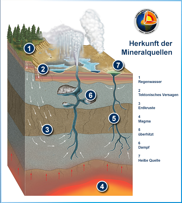
Aus einer heißen Quelle austretendes Wasser wird geothermisch erwärmt, dh mit Wärme, die aus dem Erdmantel stammt. Im Allgemeinen steigt die Temperatur der Gesteine ​​in der Erde mit der Tiefe. Die Geschwindigkeit des Temperaturanstiegs mit der Tiefe ist als geothermischer Gradient bekannt. Wenn Wasser tief genug in die Kruste eindringt, erwärmt es sich, wenn es mit heißen Steinen in Berührung kommt. Das Wasser aus heißen Quellen in nicht vulkanischen Gebieten wird auf diese Weise erwärmt.

Ein Großteil der Wärme entsteht durch den Zerfall natürlich radioaktiver Elemente. Schätzungsweise 45 bis 90 Prozent der der Erde entweichenden Wärme stammen aus dem radioaktiven Zerfall von Elementen, die sich hauptsächlich im Erdmantel befinden. Die wichtigsten wärmeerzeugenden Isotope auf der Erde sind Kalium-40, Uran-238, Uran-235 und Thorium-232.

Hier gelangt Radon ins Wasser.

Radon ist ein chemisches Element. Es ist ein farbloses, radioaktives, geruchloses, geschmackloses Edelgas. Es tritt natürlich in winzigen Mengen als Zwischenschritt in den normalen radioaktiven Zerfallsketten auf, durch die Thorium und Uran langsam in Blei und verschiedene andere kurzlebige radioaktive Elemente zerfallen. Radon selbst ist das unmittelbare Zerfallsprodukt von Radium. Da jedoch Thorium und Uran zwei der am häufigsten vorkommenden radioaktiven Elemente auf der Erde sind und drei Isotope mit sehr langen Halbwertszeiten in der Größenordnung von mehreren Milliarden Jahren aufweisen, wird Radon auf der Erde auch in Zukunft vorhanden sein von seiner kurzen Halbwertszeit, wie es ständig erzeugt wird.

Es gibt 18 Thermalquellen, die reich an Mineralien und heilendem Radon sind. Fünf Millionen Liter thermisches Radonwasser mit einer Temperatur von 40-50 ° C fließen täglich durch das Spa. Innerhalb des Naturlehrpfades ist nur eine Quelle zu sehen, die anderen Quellen sind strikt vor dem Kontakt mit Oberflächenwasser geschützt.


GEOLOGY

The formation of hot springs is directly related to the formation of the Alps.

The Alps originated as a result of a collision between the Apulian and Eurasian tectonic plates, during which the western part of the original Tethys Ocean disappeared. The great mechanical tension during their collision affected the rocks at the bottom of the Tethys basin, causing them to wrinkle, toggle rearrangements, to peel off and to the north to the foregrounds, in the form of sheets. The foreland of the Alps is formed by the European Platform and the Massif Central, Vosges, Schwarzwald and Bohemian Massif. The greatest horror-forming movements occurred in the Cretaceous, Oligocene and Miocene. During these mountain-forming processes, many older units, which today form the highest parts of the mountains, have been folded into the Alps.

The currently prevalent opinion is that rain water leaks out of the Graukogel and Hüttenkogel areas of the mountain at an altitude of about 1800 above sea level.

Due to tectonic faults, water reaches a depth of 2000 meters below the surface. Here it is heated up to 400°C.


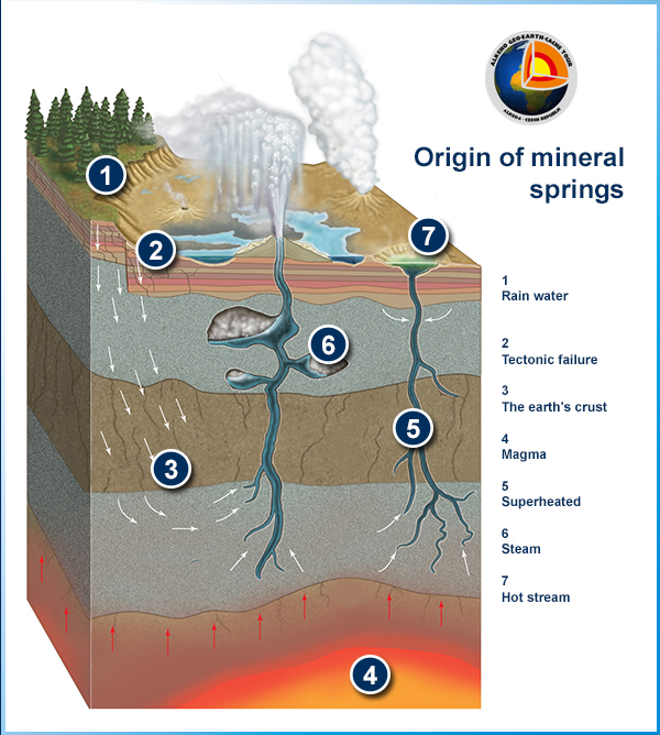
Water issuing from a hot spring is heated geothermally, that is, with heat produced from the Earth's mantle. In general, the temperature of rocks within the earth increases with depth. The rate of temperature increase with depth is known as the geothermal gradient. If water percolates deeply enough into the crust, it will be heated as it comes into contact with hot rocks. The water from hot springs in non-volcanic areas is heated in this manner.

Much of the heat is created by decay of naturally radioactive elements. An estimated 45 to 90 percent of the heat escaping from the Earth originates from radioactive decay of elements mainly located in the mantle. The major heat-producing isotopes in the Earth are potassium-40, uranium-238, uranium-235, and thorium-232.

This is where radon enters the water.

Radon is a chemical element. It is a colorless, radioactive, odorless, tasteless noble gas. It occurs naturally in minute quantities as an intermediate step in the normal radioactive decay chains through which thorium and uranium slowly decay into lead and various other short-lived radioactive elements; radon itself is the immediate decay product of radium. However, since thorium and uranium are two of the most common radioactive elements on Earth, and they have three isotopes with very long half-lives, on the order of several billions of years, radon will be present on Earth long into the future in spite of its short half-life as it is continually being generated.

There are 18 thermal springs rich in minerals and healing radon. Five million liters of thermal radon water at a temperature of 40-50 ° C flows through the spa every day. Only one spring can be seen within the nature trail, the other springs are strictly protected from contact with surface water.


ELISABETHQUELLE - Der tiefste Frühling

Benannt nach Kaiserin Elisabeth, die nach einem Kurzaufenthalt 1885 zwischen 1886 und 1893 sechsmal zur Kur in Bad Gastein weilte. Die Elisabethquelle, früher als „Hauptquelle" bzw. „St. Primus-Brunnen" bezeichnet, ist die ergiebigste der Thermalquellen Bad Gasteins. Sie soll die erste sichtbare Quelle und somit jene gewesen sein, die der Legende nach durch die Heiligen Primus und Felizian entdeckt wurde. Dem ursprünglichen St. PrimusBrunnen folgte 1819 ein Stollen, der 1823 tiefer eingetrieben wurde. 1827-29 wurde über der Quellstube das berühmte Dunstbad errichtet. Der Dampf des Thermalwassers hat eine besondere Heilwirkung und wird in speziell konstruierten Dunstbädern genossen.

ELISABETH SPRING - The most profound spring

Named after Empress Elisabeth who came to Bad Gastein for a short break in 1885 and subsequently a further six times for treatment between 1886 and 1893. The Elisabeth spring, previously known as the main spring or St. Primus spring, is the most productive of all the thermal springs in Bad Gastein. It is believed to have been the first visible spring, hence, according to the legend, the one to have been discovered by Saint Primus and Saint Felizian.
WASSERFALLWEG
The original St. Primus spring was followed in 1819 by a cave that was deepened in 1823. In 1827-29 the famous steam bath was built above the spring room. Thermal water steam has special healing properties and can be enjoyed in specially constructed steam baths.
 

Fragen und Aufgaben:

Um das Logo zu bestätigen, beantworten Sie die folgenden Fragen und Aufgaben mithilfe des Formulars oder Profils oder füllen Sie sie korrekt aus.

1) Stellen Sie sicher, bis zu welcher Tiefe das Wasser aus dieser Quelle gemäß dem Hinweisschild abfällt.

2) Nähere dich der kleinen Quelle und erkunde das Wasser, das aus ihr fließt. Wie ist es 5 Meter neben dem Wasser von den großen Quellen? Begründen Sie Ihre Entdeckung.

3) Machen Sie ein Foto von sich selbst oder einem GPS an einem kleinen Stiel.

4) Gehe jetzt zu Wegpunkt Cave. Wie tief ist diese Mineralquellenhöhle?

5) Weiter auf Wegpunkt Reissacherquelle. Nähere dich dem Gitter. Die Innentemperatur beträgt:
(a) niedriger als die Umgebungstemperatur
b) das gleiche wie die Umgebung
(c) höher als Umgebungstemperatur
Und warum?

Sie können Ihre Antworten über das Profil senden.

Questions and tasks:

To acknowledge the logo, answer or complete the following questions and tasks correctly using the form or profile.

1) Make sure to what depth the water drops from this spring according to the information sign.

2) Approach the little spring and explore the water that flows from it. How is it 5 meters beside the water from the large springs? Justify your discovery.

3) Take a photo of yourself or a GPS at a small stem.

4) Now go to waypoint Cave. What is the depth of this mineral spring cave?

5) Continue onto waypoint Reissacherquelle. Approach the lattice. The temperature inside is:
(a) lower than ambient
b) the same as the surrounding
(c) higher than ambient
And why?

You can send your answers via profile.

Otázky a úkoly:

Pro uznání logu odpovězte nebo splňte přes formulář či přes profil správně následující otázky a úkoly.

1) Zjistěte, do jaké hloubky klesá voda z tohoto pramene podle informační cedule.

2) Přistupte k malému prameníku a prozkoumejte vodu, která z něj vytéká. Čím se liší od vody ze velkém prameníku 5 metrů vedle? Svůj objev zdůvodněte.

3) Pořiďte fotografii sebe nebo GPS u malého prameníku.

4) Nyní jděte na waypoint Cave. Jaká je hloubka této jeskyně s minerálním pramenem?

5) Pokračujte na waypoint Reissacherquelle. Přistupte k mříži. Teplota uvnitř je:
a) nižší než okolní
b) stejná jako okolní
c) vyšší než okolní
A proč?

Vaše odpovědi můžete zasílat přes profil.
 

Resources:

Publish: Tourist Information Bad Gastein
Infotable in town

Thank very much Cathy Hornback from Groundspeak.


TATO CACHE JE SOUČÁSTÍ SÉRIE AGT od Alke04

Additional Hints (No hints available.)