|
Géologie
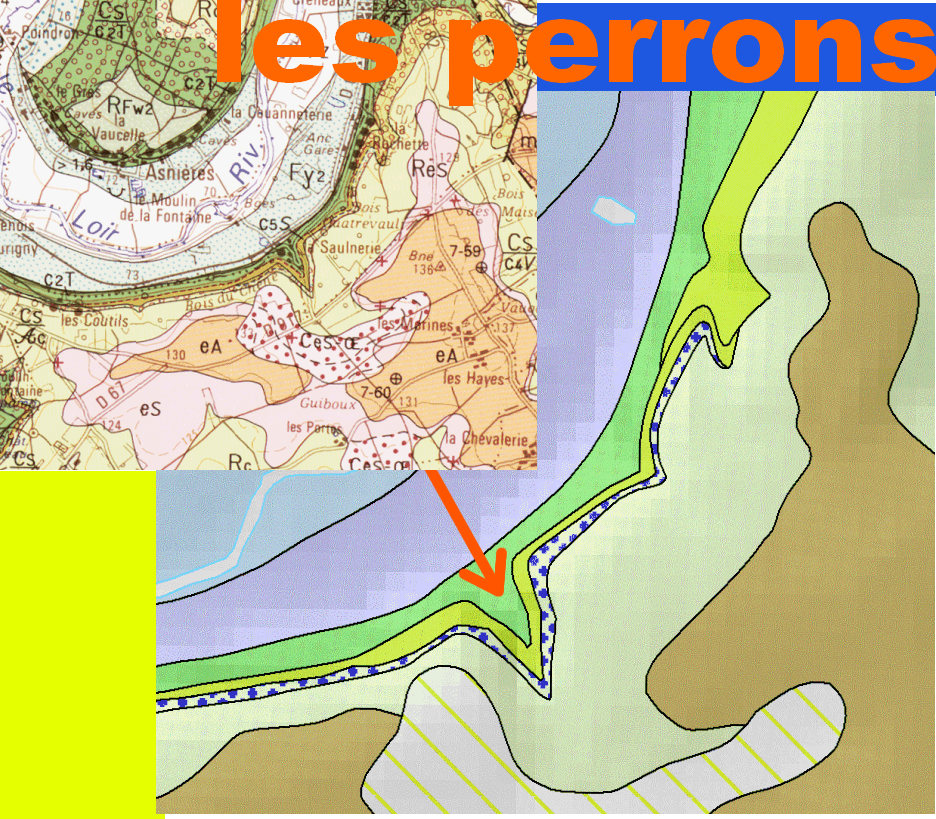
Fr :
Fz: Alluvions récentes : blocs, graviers, sables, limons et argiles tourbeuses (0 à 7 m) - Fin Pléistocène à Holocène
Fy2: Alluvions anciennes de basse terrasse (0 à 10 m) - Pléistocène
c2T :Tuffeaux blancs et jaunes : (0 à 80 m) - Turonien,moyen et supérieur.
c3V : Craie de Villedieu, partie inférieure (0 à 25 m) - Coniacien
Rc : Formation résiduelle à silex (2,5 m à 13,5 m). Altération au Crétacé terminal - Eocène inférieur
eS : Galets, sables, "perrons" et grès lustrés, argiles (0 à 15 m) - Eocène,inférieur.
eA : Argiles versicolores (9 m maximum) - Eocène inférieur
CeS-OE :Colluvions polygéniques de versan (0 à 2 m).
De gros blocs de conglomérats siliceux (« perrons ») à silex et de petites pierres de grès lustrés (sans silex) parsément l'oued, on trouve des blocs plus petits dans le bois de l'autre coté de la route.
Origine de ces blocs
La décalcification de la craie du Sénonien (-88 MA) donne les argiles à silex et les sables , ces produits d’altération continentale transportés puis déposés forment l’« Éocène détritique ».
Il y a 60 millions à 50 millions d’années le climat chaud et semi-aride, l'eau chargée en silice dissoute a circulé au niveau du sol. L’eau s’est évaporée, la silice concentrée a précipité et a scellé des grains de sable et des silex formant le conglomérat.
A l’Est et au Sud de la vallée du Loir la couche est couverte par des calcaires lacustres de l’Éocène moyen, la formation « Éocène détritique » est estimée d’âge Éocène inférieur.
Ces blocs « perrons » viennent du démantèlement de la formation « Éocène détritique » sans doute au Pléistocène lors la dernière glaciation .
En :
Fz: Recent alluvium: boulders, gravels, sands, silts and peaty clays (0 to 7 m) - Pleistocene end to Holocene
Fy2: Ancient alluvium of low terrace (0 to 10 m) - Pleistocene
c2T: White and yellow tuffeaux: (0 to 80 m) - Turonian, middle and upper.
c3V: Chalk Villedieu, lower part (0 to 25 m) - Coniacien
Rc: Flint residual formation (2.5 m to 13.5 m). Alteration on terminal Cretaceous - Eocene lower
eS: Pebbles, sands, "perrons" and glossy sandstones, clays (0 to 15 m) - Eocene lower.
eA: Versicolour clays (9 m maximum). Eocene lower
CeS-OE: Versatile polygenic colluvium (0 to 2 m).
Large blocks of siliceous conglomerates ("perrons") with flint and small stones of glossy sandstone (without flint) strew the wadi, other smaller blocks are on the other side of the road in the wood.
Origin of these blocks
The decalcification of the Senonian chalk gives the flint clays and the sands, these products of continental alteration transported and then deposited form the "detritic Eocene".
From 60 million to 50 million years ago the hot and semi-arid climate, the dissolved silica-loaded water circulated at ground level. The water evaporated, the concentrated silica precipitated and sealed sand grains and flints forming the conglomerate.
To the east and south of the Loir valley the layer is covered by the middle Eocene lake limestones, the Eocene detritic formation is estimated to be of lower Eocene age.
These "perron" blocks come from the dismantling of the formation "Etruscan detritic" probably in the Pleistocene during the last glaciation.
Glossaire
Fr : conglomérat : la silice concentrée a précipité et a scellé des grains de sable et des silex.
En : conglomerates : The concentrated silica precipitated and sealed sand grains and flints.
|