English? - Scroll down please!
Deutsch? - Bitte nach unten rollen!
Η πεζοπορία
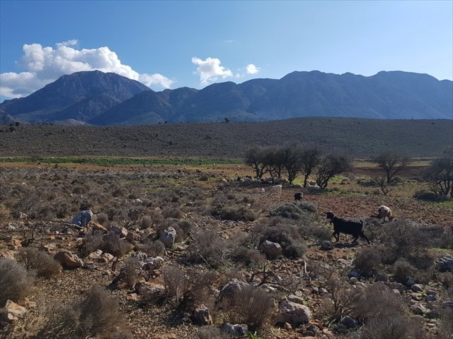
Αν βλέπετε από το χωριό του Καβούσιου στην δύση στον Κόλπο του Μιραμπέλλου, θα δείτε πίσω από τους μεγάλους ελαιώνες κάποιους λόφους. Αυτή η σειρά του geocaching σας δείχνει μια κυκλική πεζοπορία από 5 χμ. περίπου.
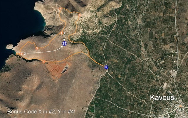
Είτε θα αφήσετε το αυτοκίνητό σας στο Καβούσι και περπατάτε μέσα στον κάμπο με πολλους ελαιώνες μέχρι το στάδιο «Trailhead: Sign Post» είτε θα πάτε με το αμάξι ως το στάδιο «Parking» σε αρκετούς καλούς χωματόδρομους ακολουθώντας τα στάδια WP1 με WP4.
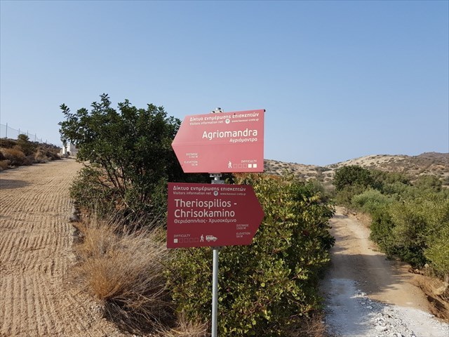
Στην πεζοπορία θα περάσετε από το πανέμορφο Φαράγγι του Αγριόμανδρα και στο τέλος του φαραγγιού μπορείτε να κάνετε κάποιες βουτιές στην ήρεμη Παραλία του Αγριόμανδρα.
Μετά θα ανεβείτε στα ερείπια της Μινωικής Αγροικίας στο Χρυσοκάμινο (περ. 1500 π.Χ.).
Από 'κει θα επιστρέψετε σε χωματόδρομους με καταπληκτική θέα στην θάλασσα και στα βουνά.
Τα ίχνη μπορείτε να κατεβάσετε:
https://www.wikiloc.com/hiking-trails/west-of-kavousi-agriomandra-chrysokamino-43955920
Οι θήρες κλειστές, που θα βρείτε, κρατάνε τις κατσίκες και τα πρόβατα στο μέρος τους. Βεβαίως, μπορείτε να τις ανοίξετε και μετά το πέρασμα σας πρέπει να τις κλείσετε σωστά!
Οι Κρύπτες
Στο πεζοπορία σας θα βρείτε επτά κρύπτες, έξι τύπου «traditional» και το Μπόνους τύπου «mystery». Για να υπολογίστε τις συντεταγμένες του Μπόνους θα βρείτε στο κουτάκι #2 τον κώδικα X και στο #4 τον κώδικα Y.
Στην περιοχή της κυκλικής πεζοπορίας υπάρχει και αυτό το geocache: Theriospilios (9V-Battery required). Αν έχετε μαζί σας μια καλή μπαταρία 9-Volt και αν σας αρέσουν τους βαθμούς εδάφους Τ4.5, μπορείτε να κάνετε ένα γύρο για να δείτε και αυτό το σπηλαίο.
Καλή διασκέδαση και φέρτε το δικό σας στυλό!
********** English: **********
The Hike “West of Kavousi”
If you are in the village of Kavousi and looking to the west to Mirabello Bay, you will see hills behind all the olive groves. This series of caches will lead you there for a circular walk of almost 5 km.
Either leave your car in Kavousi and walk through the olive groves to waypoint „Trailhead: Sign Post“ or you may go by car using the dirt roads to the given parking coordinates passing waypoints WP1 through WP4.
On your trail you will pass the impressive Agriomandra Gorge, even when it is only short, before you reach the Agriomandra Beach with excellent chance for a bath.
Then you will have to climb up to the ruins of a Minoan farmhouse (about 1500 b.chr.).
After that you will return on dirt roads with great views to the sea and the coastline.
You may download the trail:
https://www.wikiloc.com/hiking-trails/west-of-kavousi-agriomandra-chrysokamino-43955920
Closed gates are to keep sheep and goats in their areas. Fell free to open them, but don't forget to shut them carefully after passing!
The Geocaches
You will find seven geocaches on this circular walk, six of them traditional and the Bonus (mystery). For your calculation of the coordinates of the Bonus you will find at the cache #2 the code X and at #4 the code Y.
Beside of this circular walk there is another cache placed in this area: Theriospilios (9V-Battery required). Those of you who are equipped with a 9-Volt-Battery and love degree T4.5 have the chance for a little detour between #4 and #5 to visit the cave Theriospilios.
Enjoy and bring your own pen!
********** Deutsch: **********
Die Wanderung „West of Kavousi“
Wenn Ihr vom Dorf Kavousi aus nach Westen zum Golf von Mirabello schaut, liegt jenseits der Olivenhaine eine Hügelkette, die zu einer knapp 5 km langen Rundwanderung einlädt.
Lasst Euer Auto entweder in Kavousi stehen und lauft durch die Ebene mit den Olivenhainen zum Wegepunkt „Trailhead: Sign Post“ oder Ihr fahrt von Kavousi aus über die Wegepunkte WP1 bis WP4 auf einem ganz ordentlichen Feldweg zur angegebenen Parkmöglichkeit.
Auf dieser Wanderung durchquert Ihr die imposante, wenn auch kurze Schlucht von Agriomandra und besucht den pittoresken abgelegenen Agriomandra-Strand mit herrlicher Badmöglichkeit.
Danach wartet der Aufstieg zu den Überresten eines Minoischen Farmhauses (ca. 1500 v.Chr.) auf Euch.
Schließlich geht es auf Landwirtschaftswegen zurück.
Den Track findet Ihr zum Herunterladen hier:
https://www.wikiloc.com/hiking-trails/west-of-kavousi-agriomandra-chrysokamino-43955920
Geschlossene Gatter sollen die Schafe und Ziegen in ihren Bereichen halten. Ihr dürft die Gatter auf jeden Fall öffnen, wenn Ihr sie hinter Euch wieder schließt!
Die Geocaches
Auf dieser Rundwanderung könnt Ihr sieben Dosen finden, sechs Tradis und eine Bonus-Dose. Zur Berechnung der Koordinaten der Bonus-Dose findet Ihr den Code X im Cache #2 und den Code Y im Cache #4.
Nicht explizit zu dieser Rundwanderung gehört der Cache Theriospilios (9V-Battery required). Wer jedoch eine volle 9-Volt-Batterie dabei hat und die Terrain-Wertung T4.5 nicht scheut, ist zwischen #4 und #5 zu einem Abstecher zu der Höhle Theriospilios eingeladen.
Viel Spass und bringt einen Stift mit!