Skip to content

Staldzenes stāvkrasts/Steep coastline of Staldzene EarthCache

Hidden : 12/23/2019
Difficulty:
1.5 out of 5
Terrain:
1.5 out of 5

Size: Size:   other (other)

Join now to view geocache location details. It's free!

Watch

How Geocaching Works

Please note Use of geocaching.com services is subject to the terms and conditions in our disclaimer.

Geocache Description:


About / Ievads

Nature monument / Dabas piemineklis


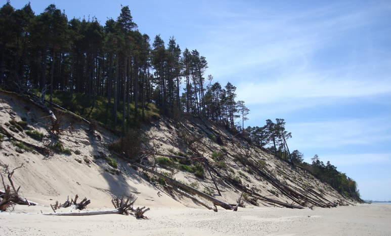
[EN] Geological and geomorphological nature monument “Steep coastline of Staldze” was created in 2001 with an area of 8.6 ha to protect and preserve unique moraine outcrops of Kurzeme glaciation, clay of the Latvian ice phase and various stages of the Baltic basin. The Staldzene outcrop is located on the Ventava Plain on the shore of the Baltic Sea 4 km to the northeast of Ventspils (northwest of Bušnieki Lake). It is a typical abrasive-type shoreline 4 to 8 m high, where deposits of various stages of the Baltic Sea are exposed for approximately 400 m. The territory of the nature monument is uninhabited, but it is a popular place for sightseeing and walking of residents and guests of Ventspils city. The most remarkable values of the natural monument are the magnificent steep sea shore, the sedimentary outcrops of various stages of development of the Baltic Basin, as well as the peculiar coastal dune forest ecosystems. As a result of the erosion of the sea, the steep coast is washed away (on average 1m per year), as a result of which the area of the natural monument is reduced and is currently ~ 6 ha.

[LV] Ģeoloģiskais un ģeomorfoloģiskais dabas piemineklis “Staldzenes stāvkrasts” izveidots 2001. gadā 8,6 ha platībā, lai aizsargātu un saglabātu unikālus Kurzemes apledojuma morēnas atsegumus, Latvijas apledojuma beigu fāzes māla un dažādu stadiju Baltijas baseina nogulumus. Staldzenes atsegums atrodas Ventavas līdzenumā Baltijas jūras krastā 4 km uz Zeimeļaustrumiem no Ventspils (uz Ziemeļrietumiem no Būšnieku ezera). Tas ir 4 līdz 8 m augsts tipisks abrāzijas tipa krasts, kurā apmēram 400 m garumā atsedzas dažādās Baltijas jūras stadijās veidojušies nogulumi. Dabas pieminekļa teritorija nav apdzīvota, bet tā ir populāra Ventspils pilsētas iedzīvotāju un viesu apskates un pastaigu vieta. Dabas pieminekļa nozīmīgākās vērtības ir ainaviski izcilais jūras stāvkrasts, Baltijas baseina dažādu attīstības stadiju nogulumu atsegumi, kā arī savdabīgas krasta kāpu meža ekosistēmas. Jūras erozīvās darbības rezultātā stāvkrasts tiek noskalots (vidēji 1m gadā), kā rezultātā dabas pieminekļa platība samazinās un šobrīd ir ~6 ha.


Steep coastline of Staldze / Staldzenes stāvkrasts


[EN] Steep coastline of Staldze is a place to enjoy the scenic seashore, the steep coastline outcrops and the coastal dune forests. The pine-covered steep coastline and the 10-20 m high cliffs formed by coastal erosion play an important role in shaping the spatial structure of the coastal landscape. Although the highest peak of the front-dune (30.8 m) is 70 m outside the territory of the nature monument, it is one of the highest dunes on the entire coast of the Latvian Sea (waypoint: Kokkalns). Staldzene steep coastline contains protected habitats of European and Latvian importance: wooded seaside dunes, boreal forests, calcareous sand meadows and gray dunes covered with herbaceous plants. There are also 8 specially protected plant species in the territory of the nature monument.

[LV] Staldzenes stāvkrasts ir vieta, kur izbaudīt ainavisko jūras krastu, stāvkrasta atsegumu dažādos slāņus un krasta kāpu mežus. Ar priedēm klātais Staldzenes stāvkrasts un krasta erozijas rezultātā izveidojušās 10-20 m augstās kraujas spēlē nozīmīgu lomu piekrastes ainavas telpiskās struktūras veidošanā. Lai arī priekškāpas augstākā virsotne (30.8 m) atrodas 70 m ārpus dabas pieminekļa teritorijas, tā ir viena no augstākajām kāpām visā Latvijas jūras piekrastē (waypoint: Kokkalns). Staldzenes stāvkrastā atrodas gan Eiropas, gan Latvijas nozīmes aizsargājamie biotopi: mežainas jūrmalas kāpas, boreālie meži, kaļķainas smiltāju pļavas un ar lakstaugiem klātas pelēkās kāpas. Dabas pieminekļa teritorijā sastopamas arī 8 īpaši aizsargājamas augu sugas.


How to get there / Kā šeit nokļūt

1. You can leave the car at the Parking 1 and follow the road directly opposite the parking lot until you reach the sea. Walking distance ~ 1.4 km.
2. You can leave the car at Parking 2 and walk along the seafront. Walking distance ~ 1,5 km.

1. Jūs varat atstāt auto pie Laivu bāzes (Parking 1) un doties pa ceļu, kurš atrodas tieši pretīm autostāvvietai, taisni līdz sasniegsiet jūru. Ceļš ar kājām ~1,4 km.
2. Jūs varat atstāt auto Staldzenes autostāvvlaukumā (Parking 2), un doties ar kājām gar jūras krastu. Ceļš ar kājām ~1,5 km.


Earth Lesson / Mācībstunda

Progression of the Baltic basin / Baltijas baseina attīstība


[EN] The Baltic Ice Lake (a) was a cold freshwater basin in the southern and central part of the present Baltic Sea valley, formed at the end of the last ice age from the melting waters of the Northern European glacier and existed at the end of the Pleistocene (approximately 13,000-10,300 years ago). This lake did not mix with the sea water from the west because the land was rising faster than sea level throughout the valley. Eventually, the confluence and connection to the ocean occurred when glaciers retreated north behind Billingen about 11,500 years ago. The Baltic Ice Lake drained, rapidly reaching sea level. From now on, the Baltic Sea became the Yoldia Sea. At this time, there was a relatively cool and relatively dry climate. The name is derived from the mussel Portlandia arctica (previously known as Yoldia arctica), which entered the sea from the Atlantic during this period. After releasing the weight of the glacier (10,700 years ago), the Baltic shield lifted and the Yoldian Sea connection to the Atlantic Ocean was broken, resulting in Lake Ancylus (c). Ancylus Lake existed during the Boreal climatic period as well as during the transition to the Atlantic period. During this time there was a relatively warm and dry climate. The name of the lake is derived from the freshwater snail Ancylus fluviatilis. About 7,500-4500 years ago, when the transgression of the sea caused the reconnection of Lake Ancylus with the Atlantic Ocean and saline water flowing through what is now Kattegat, the Littorina Sea formed. The Littorina Sea existed during the Atlantic and Subboreal climates and had a warm and humid climate at the beginning and a warm and relatively dry climate at the end. The name of the sea is derived from the snail Littorina littorea. The land rise did not close the Littorina Sea, but over time made its connection with the ocean shallower, allowing less saline water to enter, thus gradually transforming it into the present Baltic Sea with less salty water.
The traces of this process of sea formation can be seen in the outcrop of a natural monument...

[LV] Baltijas ledus ezers (a) bija auksta saldūdens baseins tagadējās Baltijas jūras ieplakas dienvidu un centrālajā daļā, kas izveidojās pēdējā ledus laikmeta beigās no Ziemeļeiropas ledāja kušanas ūdeņiem un pastāvēja pleistocēna epohas noslēgumā (pirms aptuveni 13 000—10 300 gadiem). Šis ezers nesajaucās ar jūras ūdeni no rietumiem, jo zeme visā ieplakā cēlās ātrāk nekā jūras līmenis. Galu galā sajaukšanās un savienojums ar okeānu notika, kad ledāji atkāpās uz ziemeļiem aiz Billingenes apmēram pirms 11 500 gadiem. Baltijas ledus ezers notecēja, strauji sasniedzot jūras līmeni. No šī brīža Baltijas ūdenstilpe kļuva par Joldijas jūru. Šajā laikā bija samērā vēss un salīdzinoši sauss klimats. Nosaukums veidojies no gliemenes Portlandia arctica (agrāk saukta Yoldia arctica), kas šajā periodā iekļuva jūrā no Atlantijas okeāna. Pēc atbrīvošanās no ledāja svara (pirms 10 700 gadiem) Baltijas vairogs pacēlās un pārtrūka Joldijas jūras savienojums ar Atlantijas okeānu, kā rezultātā izveidojās Ancilus ezers (c). Ancilus ezers pastāvēja boreālajā klimatiskajā periodā, kā arī pārejas laikā uz atlantisko periodu. Šajā laikā bijs samērā silts un sauss klimats. Ezera nosaukums veidojies no saldūdens gliemeža Ancylus fluviatilis. Pirms aptuveni 7500—4500 gadiem, kad jūras transgresijas dēļ atjaunojās Ancilus ezera savienojums ar Atlantijas okeānu un caur tagadējo Kategatu tajā ieplūda sāļāks ūdens, izveidojās Litorīnas jūra (d). Litorīnas jūra pastāvēja atlantiskajā un subboreālajā klimatiskajos periodos un tās pastāvēšanas laika sākumā bija silts un mitrs klimats, bet beigās silts un samērā sauss klimats. Jūras nosaukums veidojies no tur mītošā gliemeža Littorina littorea. Zemes pieaugums neaizvēra Litorīnas jūru, bet laika gaitā tās savienojumu ar okeānu padarīja seklāku, ļaujot tajā ienākt mazāk sālsūdenim, tādējādi pakāpeniski ar nedaudz sāļu ūdeni tā pārtapa pašreizējā Baltijas jūrā.
Šo jūras veidošanās procesu atstātās pēdas var redzēt dabas pieminekļa atsegumā...

Outcrop / Atsegums


[EN] The lower part of the outcrop is made up of gray clay moraine, the lithological composition of which is characteristic of Kurzeme glacier moraine. In the northern part of the outcrop it is covered by brown strip clay, formed in the end of the Latvian glaciation. In the rest of the outcrop, moraine is covered by blue-gray aleirites, aleuritic clays and light sand, formed in the preboreal / boreal climatic and Yoldia Sea / Ancylus Lake conditions. The thickness of the layer is uneven and ranges from 0.5 m up to 3 m. Deposits are relatively poor with plant macro-debris. The remains of trees found there are around 10,000 years old. The sediment of Ancylus lake is covered by a layer of sapropel and peat with shells and vivianite, formed in the conditions of the Littorina Sea Lagoon. The lower part of the layer is made up of a layer of sapropel about 0.5 to 1.9 m thick. Above, it passes into a 0.2 m thick layer of aleurite with sapropel lenses, which in turn is covered by a 0.2 to 0.5 m layer of peat in the middle of the outcrop or a layer of aleurite sand with plant debris in the southern part of the outcrop. This is in turn covered by a sandy siltstone interlayer with plant detritus and molluscan shells. The upper part of the section is made up of a 0.5 - 0.8 m thick sandy layer with aleurite lenses, plant remains and molluscan shells.

[LV] Atseguma pašu apakšējo daļu veido pelēka mālaina morēna, kuras litoloģiskais sastāvs ir raksturīgs Kurzemes (Zāles) apledojuma morēnai. Atseguma ziemeļdaļā to pārklāj brūni Latvijas (Vislas) apledojuma beigu posmā veidojušies slokšņu māli, bet atseguma pārējā daļā morēnai uzguļ preboreāla/boreāla klimatiskajos un Joldijas jūras/Ancilus ezera apstākļos veidojušies zilganpelēki aleirīti, aleirītiski māli un gaišas smiltis. Slāņa biezums ir nevienāds un svārstās no 0,5 m līdz pat 3 m. Nogulumi ir samērā nabadzīgi ar augu makroatliekām. Tajā atrastām koku atliekām ir aptuveni 10 000 gadu.
Ancilus ezera nogulumus pārsedz Litorīnas jūras lagūnas apstākļos veidojušos sapropeļa un kūdras slānis ar gliemežnīcu čaulām un vivianītu. Slāņa apakšējo daļu veido apmēram 0,5 līdz 1,9 m biezs sapropeļa slānis. Augstāk tas pāriet 0,2 m biezā aleirītu slānī ar sapropeļa lēcām, ko savukārt nomaina 0,2 – 0,5 m biezs kūdras slānis atseguma vidusdaļā vai aleirītiskas smilts slānis ar augu atliekām atseguma dienviddaļā. To savukārt pārsedz smilšainu aleirītu starpslānis ar augu detrītu un molusku čaulām. Griezuma augšējo daļu veido 0,5 – 0,8 m biezs smilšu slānis ar aleirīta lēciņām, augu atliekām un molusku čaulām.

Sea erosion / Jūras erozija


[EN] The outcrop is exposed to sea erosion, which is greatly influenced by the port of Ventspils. Based on marine coastline monitoring data, the annual deviation of the coast is estimated at 1 m. Therefore, this outcrop has a limited lifetime. Its height has also decreased in the last decade. In the 70s of the last century, the height of the steep shore reached 12 m. Rinsing a beach, front-dune, or the main coast is determined by a combination of several factors, including specific meteorological conditions - wind speed and direction during storms, air temperatures (positive or negative), which may or may not affect ground freezing and ice in the coastal zone. Hydrological and hydrodynamic conditions also play an important role in shoreline changes. High or low levels of windwaters in the shoreline during storms, waves, currents, sediment movement, including width of sea shallow, slope, amount of sediment, geological structure of shallow shoreline, impact of waves on the coast etc. The Ventspils Port Pier and the deep fairway hill have a significant impact, which completely stops the movement of natural sediment past the port to the north. Continuous sedimentation deficit in the Ventspils-Staldzene-Liepene section creates favorable conditions for erosion of the main coast. The erosion and retreat of steep coasts (especially 10-18 m high) is significantly influenced by the various slope processes (landslides, falls, suffocation, and in some cases wind deflation). Significant shoreline changes and rinses are associated with storms that occur only 1-2, less frequently, more days per year, during which 80-90% of changes occur.

[LV] Atsegums ir pakļauts jūras erozijas darbībai, kas lielā mērā ir saistīti arī ar tuvējās Ventspils ostas ietekmi. Pēc jūras piekrastes monitoringa datiem ir aprēķināts, ka katru gadu abrāzijas krasts atkāpjas vidēji par 1 m. Tādējādi šī atseguma pastāvēšanas laiks ir ierobežots. Pēdējā gadu desmitā ir samazinājies arī tā augstums. Pagājušā gadsimta 70-tajos gados augstākajās vietās stāvkrasts sasniedza pat 12 m. Pludmales, priekškāpu vai pamatkrasta noskalošanu nosaka vairāku faktoru kopums, to skaitā specifiskie meteoroloģiskie apstākļi (vēja ātrums un virziens vētru laikā, gaisa temperatūras (pozitīvas vai negatīvas), kuru ietekmē var būt vai nebūt zemes sasalums un ledus jūras krasta joslā. Būtiska loma arī hidroloģiskajiem un hidrodinamiskajiem apstākļiem (augsti vai zemi vējuzplūdu ūdenslīmeņi krasta joslā vētru laikā, viļņošanās, straumes, sanešu garkrasta transports), arī jūras seklūdens joslas platums, slīpums, irdeno smilšaini grantaino sanešu daudzums, krasta un seklūdens joslas ģeoloģiskā uzbūve (iežu noturība pret viļņu eroziju) un, protams, krasta ekspozīcija pret viļņiem, kas pienāk kastā u.c., kas tieši vai netieši ietekmē krasta joslas izmaiņas. Būtiska ietekme ir Ventspils ostas moliem un dziļajam kuģu ceļa kalnam, kas pilnībā pārtrauc dabisko garkrasta sanešu pārvietošanos garām ostai uz ziemeļiem, radot ilgstošu, nepārtrauktu sanešu deficītu Ventspils-Staldzenes-Liepenes posmā, kas savukārt rada labvēlīgus apstākļus pamatkrasta erozijai. Stāvkrasta eroziju un atkāpšanos būtiski ietekmē (it sevišķi 10-18 m augsto) dažādie nogāžu procesi (noslīdeņi, nogruvumi, nobiršana un noslīdēšana, sufozija, vietām arī vēja deflācija). Būtiskās krastu izmaiņas un noskalošana saistās ar vētrām, kas gadās tikai 1-2, retāk, vairāk dienu gadā, kuru laikā notiek 80-90% izmaiņu.

Flora


[EN] There are 8 specially protected plant species in the territory of the nature monument: Mountain Alison, Scandinavian Cotoneaster, Sand Carnation, Blue Honeysuckle, Early forget-me-nots, Pulsatilla pratensis, Bulbous Buttercup and Spring Vetch. The main botanical value is the Scandinavian Cotoneaster. This plant is found only in Ventspils and Pape area in Latvia. A total of 148 plant species have been identified in the territory of the natural monument.

[LV] Dabas pieminekļa teritorijā konstatētas 8 īpaši aizsargājamas augu sugas: Gmelina alise, Skandināvijas klintene, Smiltāja neļķe, Pallasa sausserdis, Pakalnu neaizmirstule, Pļavas silpurene, Sīpoliņu gundega un Dedestiņu vīķis. Galvenā botāniskā vērtība - Skandināvijas klintenes atradne. Šis augs Latvijā sastopams tikai Ventspils un Papes apkārtnē. Pavisam dabas pieminekļa teritorijā konstatētas 148 augu sugas.


Logging This Earthcache / Zemes slēpņa logošana
1. In your opinion, what are the two main factors that led to the formation of a steep coastline?
2. In your opinion, why this nature monument might disappear over time?
3. Explore the protected coastline along its length (From the Eartcache icon to the waypoint: The End) and describe: In which area of the coastline do you think is the gray clay moraine exposed at most, and what is the height of it (approximately)? Specify coordinates if you can (On the Application Compass screen - My Location).
4. Add a photo of you (or your team) or a private item (GPS device, geocachers stamp, or just a piece of paper with your nickname) to your log on the background of the dead tree at the end of the protected territory (waypoint: Photo Task).

Email me your answers. You don't have to wait for my approval, you can instantly log the cache as found it. If I have any questions regarding your answers, I will contact you.

Happy Earthcaching!


1. Kādu divu galveno apstākļu rezultātā, tavuprāt, ir izveidojies stāvkrasts?
2. Kā tu domā, kādēļ šis dabas piemineklis ar laiku varētu izpazust?
3. Apskatiet atsegumu visā tā garumā (No Zemesslēpņa ikonas līdz waypoint: The End) un aprakstiet: Kurā atseguma vietā, tavuprāt, vislabāk var saskatīt pelēko mālaino morēnu un cik tā ir augsta (aptuveni)? Norādi koordinātas, ja vari (Applikācijas kompasa ekrānā - My Location).
4. Pievieno savam logam fotoattēlu kurā redzams Jūs (jūsu komanda) vai kāds privāts priekšmets (GPS navigators, zīmogs vai vienkārši papīra lapiņa ar jūsu slēpņotāja vārdu) uz nokaltušā koka fona, kurš atrodas atseguma beigās (waypoint: Photo Task).

Sūtiet savas atbildes man uz e-pastu. Jums nav jāgaida mans apstiprinājums, varat uzreiz logot slēpni kā atrastu. Ja man radīsies jautājumi par Jūsu sniegtajām atbildēm, es ar Jums sazināšos.

Jauku slēpņošanu!


Don't break the law / Nepārkāp likumus

PROHIBITED:

• Drive motor vehicles off the roads, beach, forest and farmland.
• Park caravans, temporary and prefabricated structures.
• Build fires outside dedicated areas.
• Place tents outside designated areas without the landloard's permission.
• Motor boats and jet skis are not allowed in the sea. It is only allowed in places designated by the municipality.
• Don't leave trash behind.
• Do not climb the steep shore in the Natural Monument area (area between EarthCache icon and waypoint: The End).

AIZLIEGTS:

• Ar mehāniskajiem transportlīdzekļiem nobraukt no ceļiem, braukt pa pludmali, mežu un lauksaimniecības zemēm.
• Novietot speciālās dzīvojamās piekabes, pagaidu un saliekamās būves.
• Kurt ugunskurus ārpus šim nolūkam iekārtotām vietām.
• Bez saskaņošanas ar zemes īpašnieku vai tiesisko valdītāju novietot teltis ārpus šim nolūkam iekārtotām vai norādītām vietām.
• Jūrā ierīkotajās peldvietās aizliegts braukt ar motorlaivām un ūdens motocikliem. Tas atļauts tikai pašvaldības noteiktajās vietās.
• Neatstājiet aiz sevis atkritumus.
• Dabas pieminekļa zonā nestaigājiet pa stāvkrastu (zonā no Zemes slēpņa ikonas, līdz waypoint: The End).


Flag Counter

Additional Hints (No hints available.)