

Introduction
Avec cette série de Earthcaches citadines, nous allons nous intéresser aux roches typiques de la région que l’on peut observer en se promenant dans Le Havre. Cette balade va nous permettre de découvrir des spécimens de différentes familles de roches.
La sixième de la série est le grès (famille des roches sédimentaires). Dans cette étape, nous allons nous intéresser à des structures sédimentaires observées dans du grès.
Pour plus d’information sur les roches sédimentaires, vous pouvez vous référer au descriptif de l’étape 1 de cette série (§ Généralité sur les roches sédimentaires).
Les structures sédimentaires
Les structures sédimentaires se forment au cours du dépôt des sédiments. Elles sont souvent identifiées par des motifs observables dans le litage sédimentaire ou des formes distinctes dans les sédiments. En gros, si la roche sédimentaire n'a pas l'air uniforme ou présente une caractéristique distinctive, il y a de fortes chances qu'il s'agisse d'une structure sédimentaire.
La structure sédimentaire la plus simple est la stratification, c'est-à-dire les couches qui se superposent pendant la sédimentation. Les structures peuvent être plus complexes, comme les marques d’ondulations ou les motifs d'apparence chaotique dans les lits croisés.
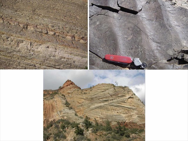
Quelques structures sédimentaires. De gauche à droite : stratification, ondulation, lits croisés
Les géologues s’intéressent à ces structures car elles leur permettent d’interpréter l'histoire de la Terre. Ainsi, ils peuvent identifier les processus qui se déroulaient lorsque les sédiments se sont déposés, le milieu de dépôt, la direction dans laquelle les sédiments se déplaçaient et/ou le mécanisme de transport des sédiments (vent, eau ou glace).
Dans ce paragraphe, seules quelques-unes d'entre elles sont abordées : les ondulations, les fissures de boue et les « flute casts ».
- Les ondulations
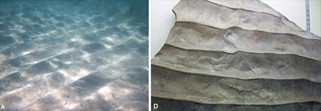
Ondulation : fond marin (actuel), ondulation dans du grès
Lorsque l'eau ou le vent se déplace sur les sédiments, il peut façonner les grains en motifs ondulés. Les ondulations symétriques sont formées par le va-et-vient de l'eau sur les sédiments. Ces types de structure se forment dans les grès provenant d'environnements marins peu profonds.
- Les fissures de boue
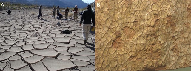
Fissure de boue : fond d’une rivière desséchée (actuel), trace fossilisée dans du grès
Les fissures de boue se forment lorsque les sédiments humides riches en argile s'assèchent. En effet, les minéraux argileux se dilatent lorsqu'ils sont humides et se rétractent lorsqu'ils s'assèchent. Lorsque le sédiment se rétracte, des fissures peuvent se développer pour former des polygones à la surface de la boue.
Une fois qu'une fissure de boue s'est formée, elle peut être remplie de nouveaux sédiments pour la formation de nouvelles couches sédimentaires.
Les fissures de boue étant généralement plus larges au sommet de la fissure et devenant progressivement plus petites vers le fond de la fissure, elles peuvent être un bon indicateur pour savoir si la surface de la roche observée est la face supérieure ou inférieure de la couche sédimentaire.
- Les « flutes casts »
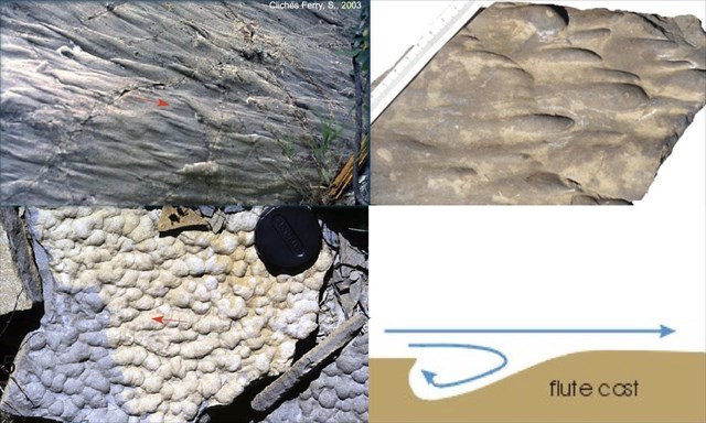
Flute-casts : flute-casts allongés, empreintes fossilisées de flute-casts allongés, flute-casts anastomosés, schéma de principe de la formation de flute-casts
Les coulées en flûte (ou flute-casts en anglais) sont formées par affouillement du fond dû aux courants (vortex). Ces structures sont reconnaissables par leur forme oblongue, allongée ou triangulaire. Elles sont généralement peu espacées et peuvent être empilées les unes sur les autres.
Là-encore, en fonction de la surface de la roche observée, on peut savoir si on est en présence de la face supérieure (formes bosselées en relief) ou inférieure (petites cuvettes) de la couche sédimentaire.
Le grès rose
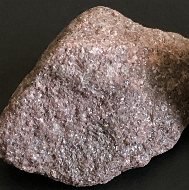
Exemple de grès rose
Le Grès rose est issu de l’agrégation et la cimentation de grains de sable qui eux proviennent du démantèlement d’un massif granitique. Il s'agit d'une roche cohérente et dure. Dans cette earthcache, nous ne connaissons pas l’origine de la roche observée. Compte-tenu de la région, elle pourrait toutefois provenir de la formation des grès fedspathiques de la carrière de Mouen dans la vallée de l'Odon. N’étant pas certain de cette hypothèse, nous allons donc rester sur une description générale de cette roche sédimentaire détritique.
Ce grès est formé par l'agglomération de grains constitués essentiellement de quartz (gris vitreux), et de feldspaths (orthoses roses et plagioclases blancs). Dans la formation des Grès feldspathiques de Mouen, le taux de feldspaths oscille entre 20 et 45 % selon les bancs ; lorsque le taux de feldspaths est supérieur à 25% la roche est une arkose.

Les sources bibliographiques
- https://uhlibraries.pressbooks.pub/historicalgeologylab/chapter/chapter4-sedimentary-structures/
- https://ivanbour.files.wordpress.com/2013/07/tp-structures-sc3a9dimentaires.pdf
- http://jacquesa14.free.fr/paleozoi/delaizeamay/gresfelds/gresfelds3.htm
- https://geologie.discip.ac-caen.fr/paleozoi/delaizeamay/gresfelds/gresfelds.htm
Pour valider la Earthcache
ATTENTION, vous êtes sur la digue du port de plaisance du Havre, veuillez respecter les lieux et n’hésitez pas de ramasser les déchets.
Outils nécessaires pour les questions de terrain : un mètre, un peu d’observation et de patiente.
Pour pouvoir valider cette EarthCache, vous devrez répondre correctement aux questions suivantes et ajouter à votre log une photo de vous, de votre GPS ou de votre pseudo au waypoint de la cache (OPTION). Cette photo permettra de valider le « trouvé » en cas de mauvaise réponse aux questions.
Merci d’envoyer vos réponses via mon profil ou via la messagerie geocaching.com, ne les donnez pas dans votre log. Les logs enregistrés sans réponses seront supprimés.
Vous pouvez loguer la cache "trouvé" sans attendre ma confirmation, je vous contacterai en cas de problème.
Rappel concernant les Earthcaches: Il n'y a pas de conteneur à rechercher ni de logbook à renseigner. Il suffit de se rendre sur les lieux, de répondre aux questions et de me renvoyer les réponses.
Question 1 : Quelle est l’utilité des structures sédimentaires pour les géologues ? Pourquoi sont-elles communes dans les formations de grès ?
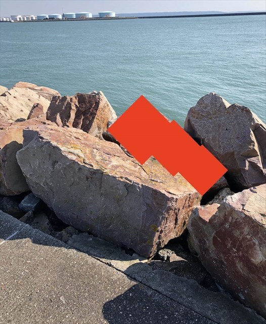
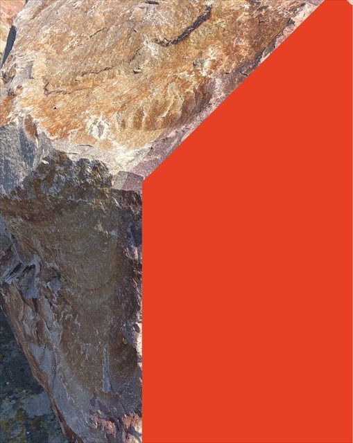
Question 2 : Rendez-vous au WP de la cache qui se situe à environ 10 m de la plaque 250 m à gauche du chemin. Pouvez-vous décrire la structure sédimentaire que vous observez sous la zone rouge ? Couleur ? Taille et forme des détails qui composent cette structure ?
Question 3 : D’après vous, est-ce que voyez la face du dessus ou du dessous de la couche de stratification de ce rocher ? Expliquez pourquoi ?
Question 4 : Pouvez-vous décrire la deuxième structure sédimentaire que vous observez sous la zone rouge d’un rocher qui se situe à 2 mètres du premier ? Taille et forme des détails qui composent cette structure ?
Question 5 : D’après vous, est-ce que ce deuxième rocher appartient à la même couche de stratification que l’autre rocher observé dans la question 2 ? Merci de justifier votre réponse et d’essayer de décrire le milieu du dépot sédimentaire associé.

Introduction
With this series of urban Earthcaches, we are going to be interested in the typical rocks of the region that we can observe while walking in Le Havre. This walk will allow us to discover specimens of different families of rocks.
The sixth of the series is the sandstone (family of sedimentary rocks). In this step, we will be interested in sedimentary structures observed in sandstone.
For more information on sedimentary rocks, you can refer to the description of step 1 of this series (§ General information on sedimentary rocks).
Sedimentary structures
Sedimentary structures form during the deposition of sediments. They are often identified by observable patterns in the sedimentary bedding or distinct shapes in the sediment. Basically, if the sedimentary rock does not look uniform or have a distinctive feature, it is likely to be a sedimentary structure.
The simplest sedimentary structure is layering, which is the layers that build up over each other during sedimentation. Structures can be more complex, such as ripple marks or chaotic-looking patterns in cross-beds.
Geologists are interested in these structures because they allow them to interpret the history of the Earth. For example, they can identify the processes that were taking place when the sediments were deposited, the depositional environment, the direction in which the sediments were moving, and/or the mechanism by which the sediments were transported (wind, water, or ice).
In this paragraph, only a few of these are discussed: ripples, mud cracks, and flute casts.
- The waves
When water or wind moves over the sediment, it can shape the grains into wavy patterns. Symmetrical ripples are formed by the back and forth movement of water over the sediment. These types of structures form in sandstones from shallow marine environments.
- Mud cracks
Mud cracks form when wet clay-rich sediments dry out. This is because clay minerals expand when they are wet and shrink when they dry out. As the sediment shrinks, cracks can develop to form polygons on the surface of the mud.
Once a mud crack has formed, it can be filled with new sediment for the formation of new sediment layers.
Because mud cracks are generally larger at the top of the crack and become progressively smaller toward the bottom of the crack, they can be a good indicator of whether the observed rock surface is the upper or lower face of the sedimentary layer.
- The « flutes casts »
Flute-casts are formed by scouring of the bottom due to currents (vortex). These structures are recognizable by their oblong, elongated or triangular shape. They are generally not very far apart and can be stacked on top of each other.
Here again, depending on the surface of the rock observed, one can tell if one is in the presence of the upper face (raised bumpy shapes) or lower face (small troughs) of the sedimentary layer.
Pink sandstone
The pink sandstone comes from the aggregation and the cementing of sand grains which come from the dismantling of a granitic massif. It is a coherent and hard rock. In this earthcache, we do not know the origin of the observed rock. Considering the region, it could however come from the formation of the fedspathic sandstone of the quarry of Mouen in the valley of the Odon. As we are not sure of this hypothesis, we will remain on a general description of this detrital sedimentary rock.
This sandstone is formed by the agglomeration of grains constituted essentially of quartz (glassy gray), and feldspars (pink orthoses and white plagioclases). In the formation of the feldspathic sandstone of Mouen, the rate of feldspars oscillates between 20 and 45 % according to the benches; when the rate of feldspars is higher than 25 % the rock is an arkose.
Bibliographic sources
- https://uhlibraries.pressbooks.pub/historicalgeologylab/chapter/chapter4-sedimentary-structures/
- https://ivanbour.files.wordpress.com/2013/07/tp-structures-sc3a9dimentaires.pdf
- http://jacquesa14.free.fr/paleozoi/delaizeamay/gresfelds/gresfelds3.htm
- https://geologie.discip.ac-caen.fr/paleozoi/delaizeamay/gresfelds/gresfelds.htm
To validate the Earthcache
ATTENTION, you are on the dyke of the marina of Le Havre, please respect the place and don't hesitate to pick up the waste.
Tools needed for the field questions: a meter, a little observation and patience.
In order to validate this EarthCache, you will have to answer the following questions correctly and add to your log a photo of you, your GPS or your nickname at the waypoint of the cache (OPTION). This photo will validate the "found" in case of wrong answers to the questions.
Please send your answers via my profile or via the geocaching.com messaging system, do not give them in your log. The logs recorded without answers will be deleted.
You can log the "found" cache without waiting for my confirmation, I will contact you in case of problem.
Reminder about Earthcaches: There is no container to search or logbook to fill in. Just go to the location, answer the questions and send me back the answers.
Question 1 : What is the purpose of sedimentary structures for geologists? Why are they common in sandstone formations?
Question 2 : Go to the WP of the cache which is located about 10 m from the 250 m plate on the left side of the path. Can you describe the sedimentary structure you see under the red area? Color? Size and shape of the details that make up this structure?
Question 3 : In your opinion, do you see the top or bottom face of the layering of this rock? Explain why?
Question 4 : Can you describe the second sedimentary structure you see under the red area of a rock that is 2 meters from the first one? Size and shape of the details that make up this structure?
Question 5 : In your opinion, does this second rock belong to the same stratification layer as the other rock observed in question 2? Please justify your answer and try to describe the environment of the associated sedimentary deposit.