Notice: "Cache seekers assume all risks and responsibilities involved in seeking this earthcache."
Warning: This is an agricultural area where many long-haul trucks full of wheat, corn, onions, potatoes, carrots, sugar beets and other commodities are busy going down the road. Most of us locals are accustomed to these trucks. If you don’t feel safe or comfortable stopping alongside the road or in a pullout to observe the geology, “Don’t Stop”. Don’t let earthcaching control you, but rather you control earthcaching. “Just because it is there, doesn’t mean you have to stop!”
“For your safety, even though the shoulder may be wide enough to stop and make observations, please park in the designated parking pullout and walk to the final. The road does get busy at times. If you feel uncomfortable with the suggested parking location, find a wider spot down the road and walk back.”
Eureka Flat: Dust Engine of the Palouse Earthcache has two virtual stages and then the final.
Virtual Stage 1, View of Eureka Flat
Virtual Stage 2, Captured Sand Dune
The final at ground zero is at a road cut through wind deposited loess.
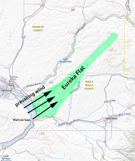
Topographical map of Eureka Flat Courtesy of the U.S. Geological Survey, Department of the Interior/USGS (Coloring and Text Added)
Within the Pasco Basin of Southeast Washington is an anomaly that stretches from Wallula Gap to Lyons Ferry State Park. This wind-swept region is known as Eureka Flat. From the Columbia River, the flat is 10 miles wide and narrows to 2 miles wide at the northern end some 40 miles away. The flat rises in elevation from 500 feet in the south to 1,000 feet in the north. On a map, Eureka Flat looks like a shallow valley, coulee or deflational plain that has been scooped out of much of its top soil over time making the area look sunken relative to the surrounding loess deposits.
14-17 million years ago, the Columbia River basalt lava flooded the region. Eureka Flat was relatively level with rolling basalt mounds on the west and east banks. 6 millions years ago, the Columbia plateau lifted from tectonic pressure. The Eureka Flat changed with it and raised from 500 feet at the southern end to 1,000 feet at the northern end. The Horse Heaven Hills slowly uplifted at the same time.
Over the epoch of time, the prevailing wind from the southwest would cascade down over the Horse Heaven Hills toward Eureka Flat. This wind would pick up velocity and amplify the wind coming through the Wallula Gap having a wind tunnel effect. Together the combined blast acted like a leaf blower blowing through the center of a pile of leaves. The wind would pick up outburst flood sediments and pile loess on the sides of the flat and blow the rest all over the Palouse to a maximum depth of 246 ft. This has been confirmed by geologist conducting research studies of soil samples across the Palouse.
The earliest sediments on the Eureka Flat was eolian basalt sands. Next came the alluvial sediments from the ancestral Columbia River, Salmon-Clearwater River and Snake River that formed the Ringold Formation of sand, gravel and cobblers at the southern end of the flat. Lastly, over serval thousand years (13-15,000 years ago) sediment from the Missoula flood outburst containing, sand, clay, silt and gravel settled over the entire flats up to 300 feet deep. (Touchet Formation and Beds) Even though most of the topsoil sediment has blown away, to this day there is as much as 200 feet of gravel and sand under Eureka Flat above the basalt flow.
Wind strength, soil moisture, vegetation growth and existing topography determined where the sediment would pile. As the dust, silt and clay was lifted, basalt sands would remain and create sand dunes throughout Eureka Flats. There are still some captured sand dunes that are exposed. Much of the remaining sands are covered over with a thin layer of Loess.
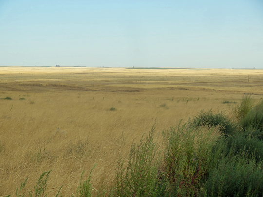
Virtual Stage 1, View of Eureka Flat: The view of Eureka Flat at an elevation of 1,000 feet looking north. Stop and enjoy the view.
Directions to virtual stage 1. Turn east off of US 12 just north of Wallula, Washington at the Port of Walla Walla and Dodd Road site sign. Drive 10 miles east on Dodd Road, then turn north on Britton Road. Apx. 1 mile to view of Eureka Flat.
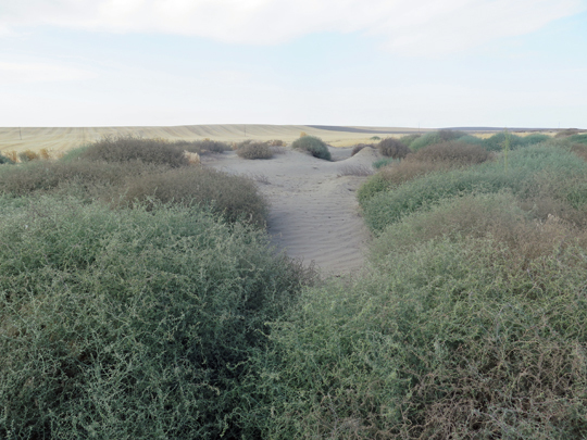
Virtual Stage 2, Captured Sand Dune: Captured dunes on both sides of Gluck Road.
Discover one of the remaining sand dunes after the dust, silt and clay was removed.
Directions to Virtual Stage 2. From stage 1, drive north 1 mile and turn east onto Gluck Road. Drive 1 mile to the captured sand dune.
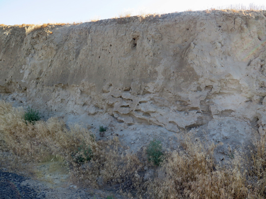
Final at Ground Zero: Inspect the thick layers of loess and the entrapped sand and gravel.
Direction to Final at Ground Zero. From stage 2. Continue east on Gluck Road. Gluck Road turns into Plucker Road. Plucker Road drop south through a ravine and onto Touchet North Road. Turn north and continue on Touchet Road north for two miles to final and ground zero.
If time permits, visit the two additional reference sand dunes located north of final on Touchet Road North at 2 miles and 3 miles respectfully.
To log this Earthcache; Please send a private message to me with answers to the following questions.
- Why is Eureka Flat a dust engine?
- At stage 1 is Wallua Gap in View?
- At stage 2 described the sand for color, size and texture.
- At stage 3 There are layers of light gravel, pebbles in a line and sand in the silt within the sediment of the loess. How do you think these layers came to be there?
Optional: You may upload a photo to the page of any local wildlife, unique vegetation or geology in the area.
Additional study and sources:
Video: Goldilocks Miracle of the Palouse | Nick on the Rocks