Rappel concernant les Earthcaches :
Attention, il n'y a pas de conteneur à rechercher ni de logbook à renseigner. Il suffit de se rendre sur les lieux d'observations puis de réaliser les conditions de validation ci-dessous.
Une Earthcache ayant comme objectif de mettre en pratique une leçon de géologie par des observations de terrain, il est conseillé de lire le descriptif afin de vous aider à répondre aux questions.
|
Questions :
1. Qu'observez-vous au bord du champ ? D’après le descriptif, d'où proviennent-ils ?
2. Quels cristaux pouvez-vous observer ? Déduisez-en le type de roche ?
3. Prenez sur place une photo de vous ou d'un élément vous identifiant avec la vallée en arrière-plan sans la zone à observer. Cette photo devra au choix nous être transmise avec les réponses ou être ajoutée à votre log.
Pour valider votre visite, envoyez-moi vos propositions de réponses soit via mon profil, soit via la messagerie geocaching.com (Message Center), et je vous contacterai en cas de problème.
Merci de ne pas publier les réponses dans vos logs.
Les logs enregistrés sans réponses et sans photo seront supprimés.
|
Un relief issu de la création des Alpes
Les monts du Forez, sont issus d’un soulèvement ou "horst" mis en place dès la fin de l’Oligocène (ère Tertiaire -34 à-23 millions d’années) suite à des mouvements tectoniques liés à la formation de la chaîne des Alpes. Cette montagne est entourée de 2 fossés d’effondrements appelés "graben" : les plaines d’Ambert (à l’ ouest, côté Puy-de-Dôme) et du Forez (à l’est, côté Loire). Ces mouvements de soulèvement et d’effondrement se sont déroulés le long de failles tectoniques encore existantes.
La roche mère (couche minérale superficielle de la croûte terrestre, dont l’altération va participer à la constitution des sols ou roche constituant le fondement d’un sol) est essentiellement granitique, hormis quelques remontées magmatiques le long de la faille à l’est du massif.
Le granite est issu du lent refroidissement du magma soumis à une pression extrême. Cette roche se compose de trois types de cristaux : Quartz, Feldspath, Micas noirs et brillants.
Une vallée modelée par la glace
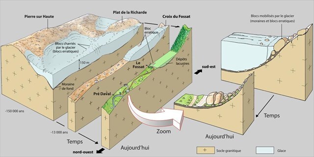
Le Fossat est composé, comme son étymologie l’indique (fossé), d’un relief abrupt marqué, érodé par d’anciens glaciers le long d’un puissant système de failles orientées nord-ouest/sud-est.
La langue de glace très lourde se déplace lentement en raison de la gravité, arrache sur son passage des blocs de roches, creuse la vallée en forme de U (en auge). De nombreuses traces de modelé glaciaire (forme de la vallée, cirque, verrous, parois abrupts polies, lac comblé, blocs erratiques et moraines de fond, latérales et frontales) sont encore visibles pour l’ oeil averti.
Il y a encore 13 000 ans, les glaciers occupaient la vallée des crêtes jusqu’à 4 ou 5 km en aval, avec une épaisseur maximal de 150 mètres.
La vallée du Fossat est, avec la vallée voisine des Reblats (située sur la même faille), et celle de Chorsin côté Loire, l’une des trois principales vallées glaciaires des monts du Forez. D’autres existent dans le massif du Sancy (Chaudefour, Fontaine salée, Mont-Dore) ou dans le Cantal.

Reminder regarding EarthCaches :
Please note: there is no container to search for and no logbook to sign. Simply visit the observation sites and fulfill the validation requirements listed below.
As the goal of an EarthCache is to put a geology lesson into practice through field observations, it is recommended that you read the description to help you answer the questions.
|
Questions :
1. What do you observe at the edge of the field ? According to the description, where do they come from ?
2. What crystals can you observe ? Deduce the type of rock from this ?
3. Take a photo on-site of yourself or an identifying object with the valley in the background, excluding the area to be observed. You may either submit this photo along with your answers or add it to your log.
To validate your visit, send me your proposed answers either via my profile or via geocaching.com messaging (Message Center), and I will contact you in the event of a problem.
Please do not post the answers in your logs.
Logs recorded without answers and without photos will be deleted.
|
A landform resulting from the formation of the Alps
The Forez Mountains originated from an uplift—or "horst"—that formed during the late Oligocene (Tertiary period, 34 to 23 million years ago) as a result of tectonic movements linked to the formation of the Alps. The range is flanked by two rift valleys, or "grabens": the Ambert Plain (to the west, in the Puy-de-Dôme department) and the Forez Plain (to the east, in the Loire department). These uplift and subsidence movements occurred along tectonic faults that remain active today.
The bedrock (the superficial mineral layer of the Earth's crust, the weathering of which contributes to soil formation, or the rock forming the foundation of a soil) is essentially granitic, except for a few magmatic upwellings along the fault to the east of the massif.
Granite forms from the slow cooling of magma subjected to extreme pressure. This rock is composed of three types of crystals: quartz, feldspar, and shiny black mica.
A valley shaped by ice
As its etymology (meaning "ditch" or "trench") suggests, Le Fossat is characterized by steep, rugged terrain eroded by ancient glaciers along a major fault system running northwest-southeast.
The massive tongue of ice moves slowly under the force of gravity, tearing away blocks of rock in its path and carving out a U-shaped valley (glacial trough). Numerous signs of glacial sculpting—such as the valley shape, cirques, rock bars, polished steep walls, filled-in lakes, erratic boulders, and ground, lateral, and terminal moraines—remain visible to the trained eye.
As recently as 13,000 years ago, glaciers occupied the ridge valley, extending 4 or 5 km downstream and reaching a maximum thickness of 150 meters.
The Fossat Valley—along with the neighboring Reblats Valley (located on the same fault line) and the Chorsin Valley on the Loire side—is one of the three main glacial valleys of the Forez Mountains. Others are found in the Sancy Massif (Chaudefour, Fontaine Salée, Mont-Dore) or in the Cantal.
Source : Plaquette Espace Naturel Sensible "Vallée du Fossat".