Now this is a long description! If you want only the directions
for finding the cache, start at the dark blue lettered part below.
I seem to have developed a new hobby, i.e. making cache
containers that people have to figure out how to open.
 This one is
constructed out of PVC pipe inside of which is a gizmo I found
on a curb while geocaching with some of my senior students on
our first night in San Antonio, senior trip 2005. It was their
first time geocaching. Anyway, I thought that someday I might
figure out a use for that piece of junk and so I have. It's
part of this container now! I still don't know what it is.
It's up to you to figure out how to get at the inside w/o
breaking the container.
This one is
constructed out of PVC pipe inside of which is a gizmo I found
on a curb while geocaching with some of my senior students on
our first night in San Antonio, senior trip 2005. It was their
first time geocaching. Anyway, I thought that someday I might
figure out a use for that piece of junk and so I have. It's
part of this container now! I still don't know what it is.
It's up to you to figure out how to get at the inside w/o
breaking the container.
Inside this cache you will find a pretty good picture of
Waterloo that was taken by an astronaut while aboard the
International Space Station (ISS). On the image (one on the front
of the page and one on the back) are marked your location while
standing at the cache and vehicles barely visible on the road.
Astronauts in orbit can easily see larger roads, like Martin Luther
King drive in Wloo w/o optical aid! On a 12 inch globe they would
be orbiting only 2/3 of an inch above the surface. Most people
don't realize that they are not very far up, relatively speaking.
With binoculars they should be capable of spotting vehicles! I once
heard Sally Ride, the first American woman astronaut say (while up
at UNI in Cedar Falls) that if she new where to look she would have
been able to spot it at night) the lights at her favorite 711 gas
station.
I also have a small version of the Wloo picture at the cache
that if you look at it at 5.4 feet away you will see Wloo at the
same size as the astronauts saw it when they were flying over.
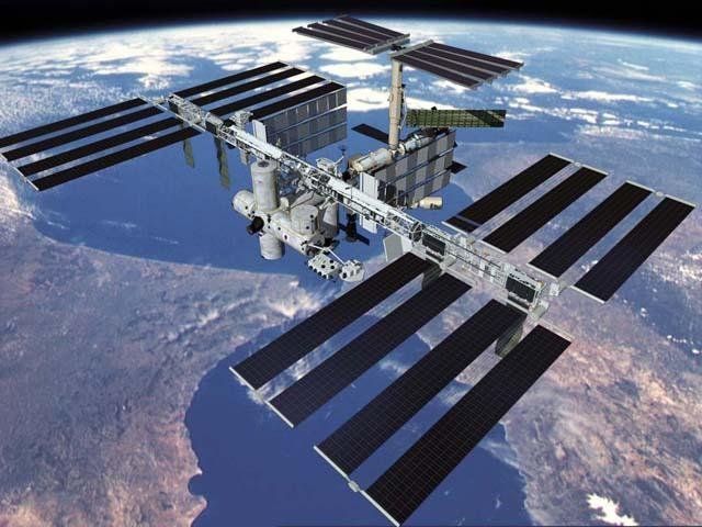
This artist's depiction of the Station shows what it will look
like if ever it gets completed. They say it'll reflect so much
sunlight that it'll be visible even in a blue sky! I'm sure you
would have to know right where to look to see it in daylight
however. Like a person can see Venus in a blue sky when the planet
is bright and far from the sun IF you look right at it.
The reason the Wloo from space image is so meaningful to me is
related to what I say following. In April 2003 I was set up to
reflect sunlight from three large mirrors toward Don Pettit. That
would be of no surprise expect for the fact that Pettit was just
over 200 miles away, straight up! At the time he was aboard the ISS
acting as the science officer. On that day, the ISS transited
(crossed ) the center of the sun as I saw it from the Hawkeye
Community College grounds. Coincidentally the track of the
"centerline" of the transit swept right over the Hawkeye campus. I
invited the astronomy professor to take his class out to see it
occur. He took up my offer. They watched a projected image of the
sun on the wall of the building next to my 8" telescope which I set
up for them. I was manning a large mirror and my 5" scope with a
video camera attached to record the event. My son and daughter (who
I had taken out of school to help me) were also holding a large
mirror each. At the moment of the occurrence I heard some students
yell out that they saw a black speck wiz across the sun's disc. One
can see the ISS cross the sun in my video, albeit just barely.
Unfortunately, Pettit "had his ands in the glove-box" as he put
it. He had finally gotten the "glove-box" - the compartment they
conduct science experiments in - working again and didn't want to
break away. The reason this was such a hullabaloo is that this was,
as far as I know, the first solar transit by the ISS to be
videotaped by anyone. I was using data provided by Tom Fly. He has
developed a program that a person can subscribe to via e-mail. It
tells you when the ISS will transit the sun, Moon, Mars, Venus,
Jupiter or Saturn as seen from a place of your choosing. I got
signed up as soon as he developed the program.
To the right here is a picture of Don Pettit looking out the big
window in the ISS. It was probably the same window he looked out in
trying to spot my mirror
reflection.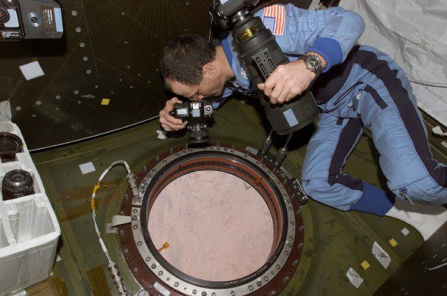
Don Pettit gave me one more opportunity to signal him with a
mirror. This time he was not directly in front of the sun so doing
the geometry was a lot harder. He was looking one day in early May
2003 when he passed just N of Waterloo. However, even though he
said "the sky was beautifully clear down there"
Just in 1/19/07. Take a look at this new NASA
Reference Guide to the International Space Station!
You will probably
discover that finding the final cache may be quite challenging. You
will be best to use Google Map satellite images, Black Hawk County
Online and any other geocaching map resource you can come up with.
Being a “premium member” should give you an advantage. It’ll allow
you to get to interactive maps that will make part of this task
easier. To test the coord you come up with click
here.
Now to begin: In the
end you are going to end up with a number that you will used to
correct a coord that is in error. That will give you the coord for
the final cache.
(1) There is a cache
owned by Iowa Tom (IT) that is 0.87 miles from the coordinates
posted on this cache page. From now on I will be referring to those
coords as the “home coords.” That cache is generally W (heading =
270 degrees) of the home coords. [If you need to you can set up a
go-to in your GPSr to the home coords and drive around till your
GPSr reads 0.87 miles and a bearing of 70 degrees, that is assuming
however that you have custom set the display to read bearing and
distance. At that distance and bearing you will be very close to
the cache in question.]
Once that cache is
found cut and paste (or copy) its name to a blank Word document.
Next run all the words together by taking out the spaces between
them. You will be doing the same thing for the names of several
other caches.
(2) Open image 1 and
figure out what the name of the IT cache that is located in the
circle. You may want to use the satellite images presented by
Google at this
URL. then use geocaching.com to determine which cache is
there. Once found, paste its name to the end of the other cache’s
name and again, take out all the spaces. You are going to be
counting letters soon.
(3) Open image 2 and
figure out what the name of the IT cache that is located in the
circle. Once found, paste its name to the end of the other cache’s
name and again, take out all the spaces.
(4) Open image 3 and
figure out what the name of the IT cache that is located in the
circle. Once found, paste its name to the end of the other cache’s
name and again, take out all the spaces.
(5) Now for the Word
document you started: go to File, Properties, Statistics,
Characters. Make note of how many characters there are. You will be
in need of that number. Type it out now. Call it “A”. NOTE: if
the “Characters” and “Characters (with spaces)” numbers are
different, you missed a space! Also make sure you did not
accidentally delete a letter.
(6) Open image 4 and
locate that house using Google
Maps and Black
Hawk County Online [BHCO]. At BHCO click on "Real Estate
Mapping" to get to the mapping software. Once you find that house
at BHCO, open the Detailed Report (on the left side of the webpage)
and scroll down to the bottom left of that info. There you will see
listed the year that house was built. Keep track of that number as
“B”. If you give up using BHCO the name of this house is listed
under National Register of Historic Places in Black Hawk County. A
Google search using info obtained there can provide you with a URL
that will list the date of construction of both this place and the
one in image #5. Hint: an anagram of the name of the house in image
#4 is "NURSE DOM".
(7) Open image 5 and
locate the small stone building that is on the property of a
church. Use Google maps and BHCO to determine when that stone
building was constructed. The date it was built is located in the
on the lower left of the Detailed Report after the words: 1S STONE
BLDG. Keep track of that number as “C”.
(8) Finally, open
image 6 and using whatever means at your disposal, locate the
numerical value of the address of the house that is boxed in. It’s
the 3rd one W of the corner. You may want to double check that you
got the right place by seeing whether it was built in 1911 or not.
Keep track of that number as “D”. [By the way, I lived at that
house when I was 7 and younger.]
Now use the following
mathematical sequence for determining the correct latitude. (((A x
20) + B + C + D) - 8) divided by 10,000 added to the minutes in the
incorrect longitude W 92 19.279 = the corrected longitude. The
correct latitude is N 42 27.247.
Here's something for fun. The right most of the three images
here shows the clearest shot of the Space Station I have ever seen
taken during a solar transit. Click on it to see it closer. A movie
of that transit is available at
this website. To see it click on the
word video. It’s a fantastic slow motion of the images that were
put together to make the composite. On 7/12/06 John Locker in
England took
this movie of a transit of the ISS
with Shuttle attached transiting the sun at
this location. Click on the two
videos below to see the ISS transiting part of the moon and passing
very close to Saturn. What a shot that Saturn one is! John has a
compiled a lot of his ISS transit videos at
this location. I think
this one is my favorite. Hang on,
it's slow to load.


Iowa Tom Iowa
Tom