Lahar Power Ruapehu EarthCache
-
Difficulty:
-

-
Terrain:
-

Size:  (other)
Please note Use of geocaching.com services is subject to the terms and conditions
in our disclaimer.
Mount Ruapehu is an active stratovolcano at the southern end of the Taupo Volcanic Zone in New Zealand.
Do Not include answers in your log.
NOTE: Change in questions January 2019, due to new signage.
To claim this cache, you need to complete the following tasks. Please forward your answers by email me direct - earthcache@wallace.net.nz - if you use GC.com message centre, then there will be a delay in response Once you have sent your email, you may log your find. Ensure you upload your photo.
At the listed waypoint.
Q1. In the year 1947, what was the percentage level / full was the crater lake?
Q2. In 1953, what was the name of the person who tried to warn the train diver about the bridge by waving a torch?
Q3. What is the code of the third carriage of the 1953 train = letter and number combination.
Q4. Describe the bank on the far side of the Whangaehu River. Estimate it's height. Describe any material or layers you can see.
Q6. What is the Maori name given to Mr Ruapehu's crater lake?
6. Go to monument at S 39 27.956 E 175 34.576 Take a photo of yourself and GPSr (both clearly visible) with the monument.
This is a requirement - NOT optional, as it verifies your visit to the site.
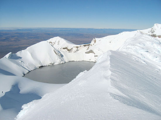
Ruapehu is one of the world's most active volcanoes and the largest active volcano in New Zealand. It is the highest point in the North Island and includes three major peaks: Tahurangi (2,797 m), Te Heuheu (2,755 m) and Paretetaitonga (2,751 m). The deep, active crater is between the peaks and fills with a crater lake between major eruptions.
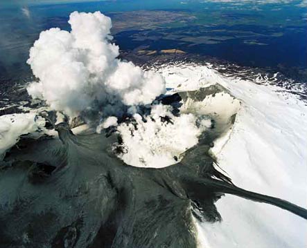
Hazards posed by volcanoes usually bring to mind lava flows and clouds of ash. Yet some of the worst hazards emerge long after the eruptions have stopped. Lahars are mudflows of water, volcanic ash, and volcanic rocks. Melting snow and rain can form lakes that sit heavily and uneasily in volcanic calderas. If the volcanic lake breaks through the surrounding rock, a lahar pours down the volcano’s flank.
Between major eruptions, a warm acidic crater lake forms, fed by melting snow. Major eruptions may completely expel the lake water. Where a major eruption has deposited a tephra dam across the lake's outlet, the dam may collapse after the lake has refilled and risen above the level of its normal outlet, the outrush of water causing a large lahar. More than 60 lahars have been recorded in the Whangaehu Valley below the mountain since the 1860s.
The 1945 eruption emptied the crater lake and dammed the outlet with tephra. The crater slowly refilled with water, until on December 24, 1953 the tephra dam collapsed causing a lahar in the Whangaehu River. The lahar caused the Tangiwai disaster, with the loss of 151 lives, when the Tangiwai railway bridge across the Whangaehu River collapsed while the lahar was in full flood, just before an express train crossed it. It was already known that the river had partially undermined one of the bridge piers and the lahar finished the job, causing the bridge to collapse. Although warned of the collapsed bridge, the train driver was unable to stop the train in time and 6 of the carriages fell into the river.
Spectacular eruptions occurred during 1995 and 1996. Ruapehu had been showing signs of increased activity since late November 1994, with elevated crater lake temperatures and a series of eruptions that increased in intensity over about nine months. Several lahar were observed, both in the Whangaehu River and other areas of the mountain, between September 18 and September 25, 1995, indicating the crater lake was being emptied by the eruptions. The Department of Conservation immediately issued hazard warnings and advised people to keep off the mountain, thus ending the ski season. The eruption cloud disrupted air travel, occasionally closing airports and the central North Island airspace. Episodic eruptions continued until the end of November 1995.
Ruapehu erupted at 10.30pm on 4 October 2006. The small eruption created a volcanic earthquake of magnitude 2.8, sending a water plume 200 m into the air and 6-m waves crashing into the wall of the crater.
On 18 March 2007, the 7 metre tephra dam which had been holding back the crater lake burst, sending a lahar down the mountain. The escaping water gouged out rocks and earth and other debris carrying them down the mountain. An estimated 1.4 million cubic metres of mud, rock, and water thundered down the Whangaehu river, with the standing wave reaching a height of 4 metres.
The Department of Conservation had received warning signals from the lahar warning system (ERLAWS) at around 10:30 that morning and closed all major roads in the area and shut down the main rail system for the North Island. Luckily the river banks held and no major spill overs occurred. No serious damage was done and no one was injured. One family was trapped for around 24 hours after the lahar swept away the access route to their home.

See the recording of the lahar in action on the following link. (click on this link)
At this location, close to where the rail bridge of 1953 was swept away, there is a memorial to the victims, survivors and rescuers of the Tangiwha Disaster. Until 18 March 2007, this was a popular spot for travelers to rest. A toilet block was sited here. After the morning of 18 March 2007, this area was covered in acidic mud, which had flowed from the crater rim, down the Whangaehu channel, and rising to several metres at the bend behind where the toilets stood, and up and over the bank. It had followed the same path of Christmas Eve 1953. All that was left of the toilet block was one pipe embedded into the bank (There was a regular geocache adjacent in a flax bush at the time of the lahar).
Additional Hints
(Decrypt)
[Visit all signs on this site......To claim this cache, you need to complete the following tasks. Please forward your answers by email me direct - earthcache@wallace.net.nz - if you use GC.com message centre, then there will be a delay in response
Q1. In the year 1947, what was the percentage level / full was the crater lake?
Q2. In 1953, what was the name of the person who tried to warn the train diver about the bridge by waving a torch?
Q3. What is the code of the third carriage of the 1953 train = letter and number combination.
Q4. Describe the bank on the far side of the Whangaehu River. Estimate it's height. Describe any material or layers you can see.
Q6. What is the Maori name given to Mr Ruapehu's crater lake?
6. Go to monument at S 39 27.956 E 175 34.576 Take a photo of yourself and GPSr (both clearly visible) with the monument.
This is a requirement - NOT optional, as it verifies your visit to the site.