
La Earthcache / The Earthcache
Situé à 875 mètres d'altitude, le lac Chambon est un des principaux lacs présents entre le massif du Sancy, vaste strato-volcan, et la Chaîne des Puys, ensemble volcanique beaucoup plus récent.
D'une forme oblongue, ce lac s'étend dans la vallée de la Couze Chambon sur une surface importante, près de 60 ha, mais présente une faible profondeur (4 mètres au maximum).
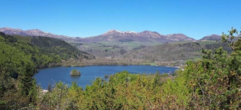
A la différence des lacs de la région souvent hérités de maars comme le lac Pavin, il est le résultat d’un double barrage volcanique et gravitaire dont témoigne la formation géologique de la zone.

► A l'origine courrait la Couze de Chaudefour
L'histoire de la Vallée de la Couze de Chaudefour débute il y a 500 000 ans avec la mise en place du strato-volcan du Sancy.
De ces flancs déchirés jaillissent de nombreux cours d'eau, dont la Couze de Chaudefour, débutant la mise en place d'une vallée fluviale.
Cette vallée s'est complètement métamorphosée entre -100 000 ans et -16 000 ans avec la glaciation Würm, dont le retrait donne une vallée caractéristique en U, la vallée du Chaudefour.
Il s'agit à cette époque d'une vallée torrentielle post-glaciaire creusée par un impétueux torrent filant vers la plaine de la Limagne pour rejoindre l'Allier.
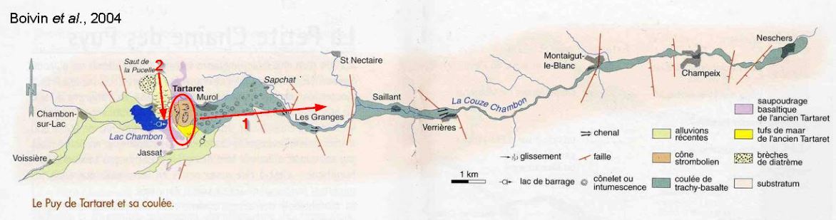
► Vint alors le terrible Tartaret...
Il y a 16000 ans, un nouvel épisode volcanique (un des plus récents d'Auvergne) vient chambouler cette paisible vallée.
Une série d'éruption donne naissance au puy du Tartaret, volcan complexe présentant 3 cônes de scories :
- 16 000 ans dépôts de maar => éruption phréatomagmatique (Tartaret 1) : construction d'un cratère de maar
-16 000 ans et – 8 500 ans => éruptions stromboliennes (Tartaret 2) : construction des deux cônes de scories du Tartaret, dont l'un des cratères est légèrement égueulé vers le nord
-16 000 ans et – 8 500 ans => émission de coulées de lave, la plus longue atteignant 22 kilomètres
Ces différentes éruptions vont mettre en place des formations géologiques de deux natures :
- Des amoncellements de scories pyroclastiques, fragments de roches solides expulsés pendant l’éruption d’un volcan, lorsque les gaz sont relâchés par décompression et éjectés de l'évent. Ces roches ont un aspect de roche détritique, peu cohérente, souvent friable, fait d'un agglomérat de clastes de couleur rouge ou noire avec des formes vacuolaires.

- Des vastes formation de basalte, roche dure, cohérent, non grenue (les cristaux ne sont pas visibles à l'oeil nu) et de couleur très sombre (mafique).
Ces formations volcaniques vont s'accumuler en travers de la vallée et barrer la route de la Couze de Chaudefour, et par un phénomène de barrage naturel permettre la formation du lac Chambon.
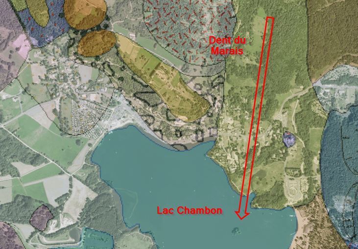
► ...Suivi de la Dent du Marais
Sur les rives nord du lac, se trouvait le volcan de la Dent du Marais.
Ce volcan très instable subit un effondrement de son flanc sud du diatrème et d'une partie de son encaissant dans le cadre de deux importants glissements de terrain, il y a 8000 ans et 3000 ans.
Il ne subsiste alors que la dent du Marais, une imposante muraille rocheuse de 100 mètres de haut culminant à 943 mètres d'altitude.
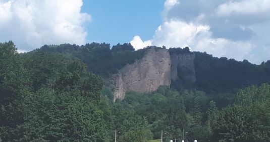
Les dépôts disloqués de ces flancs, des blocs de brèches d'explosion de cet ancien volcan et des fragments de plaques de diatomites, forment le site de la presqu'île de l'est du lac Chambon et la fameuse « île d'Amour ».
At an altitude of 875 meters, Lake Chambon is one of the main lakes present between the Sancy massif, a vast stratovolcano, and the Chaîne des Puys, a much more recent volcanic ensemble.
Of an oblong shape, this lake extends in the valley of Couze Chambon on a large surface, nearly 60 ha, but presents a shallow depth (4 meters maximum).
Unlike the lakes of the region often inherited from maars such as Pavin Lake, it is the result of a double gravity and volcanic dam testified by the geological formation of the area.
► Originally run Couze de Chaudefour
The history of the Couze de Chaudefour Valley begins 500,000 years ago with the setting up of the Sancy stratovolcano.
From these torn flanks gush out many rivers, including the Couze de Chaudefour, beginning the establishment of a river valley.
This valley has completely metamorphosed between -100 000 years and -16 000 years with the Würm glaciation, whose withdrawal gives a U-shaped valley, the Chaudefour valley.
It is at this time a torrential valley post-glacial excavated by an impetuous stream running towards the plain of Limagne to join the Allier.
► Then came the terrible Tartaret ...
16,000 years ago, a new volcanic episode (one of the most recent in Auvergne) disrupts this peaceful valley.
A series of eruptions gives birth to the puy du Tartaret, a complex volcano with 3 slag cones:
- 16 000 years maar deposits => phreatomagmatic eruption (Tartaret 1): construction of a maar crater
-16,000 years and - 8,500 years => Strombolian eruptions (Tartaret 2): construction of the two Tartaret slag cones, one of whose craters is slightly rudely northward
-16 000 years and - 8 500 years => emission of lava flows, the longest reaching 22 kilometers
These different eruptions will set up geological formations of two natures:
- Stacks of pyroclastic slags, fragments of solid rocks expelled during the eruption of a volcano, when the gases are released by decompression and ejected from the vent. These rocks have a detrital rock appearance, inconsistent, often friable, made of an agglomerate of red or black clasts with vacuolar forms.
- Extensive formation of basalt, hard rock, consistent, ungreened (the crystals are not visible to the naked eye) and very dark (mafic).
These volcanic formations will accumulate across the valley and block the Couze de Chaudefour road, and by a natural dam phenomenon allow the formation of Lake Chambon.
► ... Follow the Dent du Marais
On the northern shores of the lake, was the volcano Dent du Marais.
This very unstable volcano undergoes a collapse of its south flank of the diatrème and part of its casing within the framework of two important landslides, 8000 years ago and 3000 years ago.
All that remains is the tooth of the Marais, an imposing rock wall of 100 meters high, at an altitude of 943 meters.
The dislocated deposits of these flanks, blocks of explosion breccias of this ancient volcano and fragments of diatomite plaques, form the site of the eastern peninsula of Lake Chambon and the famous "Island of Love".
► Sources bibliographiques / Bibliographical sources
Les Questions / The Questions
La lecture attentive du descriptif de la cache, ainsi qu'une observation des éléments de terrain et un peu de déduction sont normalement suffisants pour répondre aux questions de cette EarthCache.
A careful reading of the description of the cache, as well as observation of terrain features and some deduction is usually sufficient to answer questions of this EarthCache.
Questions pour valider :"Chambon 1 - Et le Lac fut..."
Questions to validate: "Chambon 1 - And the lake came ..."
Point 1 : N 45° 34.056' E 2° 55.643'
Vous voici au bord du lac sur le sentier de petite randonnée.
Dos au lac, près d'un panneau de forme triangulaire, vous pouvez étudier un vastement affleurement en pente exempt de végétation.
Here you are by the lake on the small hiking trail.
Back to the lake, near a triangular panel, you can study a broadly outcrop slope without vegetation.
- Question 1 : Décrivez cet affleurement : sol cohérent ou meuble, couleur et taille de ces éléments. De quoi s'agit-il ? Essayez de monter la pente ; le panneau est-il justifié ?
- Question 1 : Describe this outcrop: consistent or loose soil, color and size of these elements. What is it about ? Try to climb the slope; is the sign justified?
- Question 2 : Déduisez-en le lien de cette couche géologique avec la formation du lac Chambon.
- Question 2 : Deduce the link of this geological layer with the formation of Lake Chambon.
Point 2 : N 45° 34.131' E 2° 55.767'
Vous voici sur la plage de Chambon, avec une vue parfaite sur le lac et ses alentours.
Here you are on the beach of Chambon, with a perfect view of the lake and its surroundings.
- Question 3 : Tournez vous dans la direction Nord/Nord-Ouest, que voyez-vous ?
- Question 3 : Turn north / northwest, what do you see?
- Question 4 : Regarder maintenant plein Ouest ; que voyez-vous sur le lac ?
- Question 4 : Watch now full West; what do you see on the lake?
- Question 5 : En utilisant le descriptif, déterminer le point commun de vos observations des questions 3 et 4 et déduisez-en le lien avec la formation du lac Chambon.
- Question 5 : Using the description, determine the common point of your observations of questions 3 and 4 and deduce the link with the formation of Lac Chambon.
Vous pouvez vous loguer sans attendre notre confirmation,
mais vous devez nous envoyer les réponses en même temps soit par mail via notre profil (
fafahakkai), soit via la messagerie geocaching.com (Message Center).
S'il y a des problèmes avec vos réponses nous vous en ferons part.
Les logs enregistrés sans réponses seront supprimés.Une photo de vous ou de votre GPS le lac Chambon en arrière plan est la bienvenue, mais n'est pas obligatoire.
You can log this cache without waiting for our confirmation, but you must send us the answers at the same time, by e-mail via our profile (fafahakkai) or by the system of Message Center of geocaching.com.
If there is a problem with your answers we will notify you. The logs recorded without answers will be deleted.
A photo of you or your GPS Lake Chambon in the background is welcome, but not mandatory.
Rappel concernant les « Earthcaches »: Il n'y a pas de conteneur à rechercher ni de logbook à renseigner. Il suffit de se rendre sur les lieux, de répondre aux questions ci-dessus et de nous renvoyer les réponses.
Reminder concerning "Earthcaches": there is neither a container to look for nor a logbook to sign. One need only go to the location, answer to the differents questions and send us the answers.