#1 TDL - Les étangs du Louroux... EarthCache
#1 TDL - Les étangs du Louroux...
-
Difficulty:
-

-
Terrain:
-

Size:  (other)
Please note Use of geocaching.com services is subject to the terms and conditions
in our disclaimer.
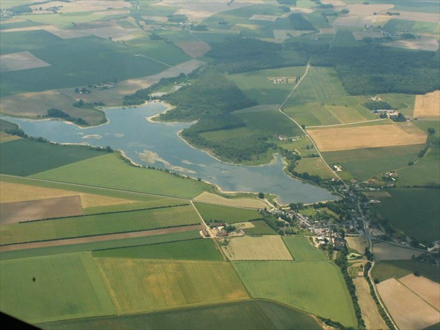
Etang des roseaux... 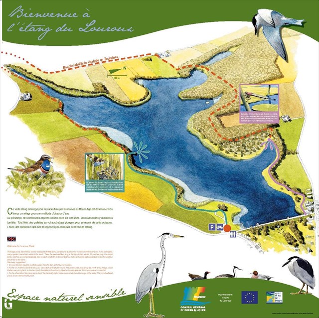 Sur ce site, le relief est peu important, mais grâce à une partie creuse en son centre, cette petite dépression est à l'origine de ce superbe plan d'eau.
Le site du Louroux est composé de deux étangs, nommés étang des Roseaux et étang de Beaulieu, qui ont une superficie respective de 52 ha et 4 ha.
L'étang principal est celui des roseaux...
Ce plan d'eau est un des plus grands de la région. Et aussi et surtout un des plus beaux, ce pourquoi il est protégé.
Une faune (pas moins de 150 espèces ont été observées entre 1972 et 1993 dont certaines très rares. ) et une flore exceptionnelle en font sa renommée.
RESPECTEZ LA REGLEMENTATION DU SITE LORS DE VOTRE BALADE...
 SON ORIGINE GEOLOGIQUE :
D’un point de vue géologique, l’étang du Louroux se trouve sur une vaste zone d’argiles à silex du Sénonien qui affleure localement sur de grandes surfaces. Ces argiles bordent l’étang sur l’ensemble de son périmètre, en étant toutefois très réduites vers l’Est. La structure géologique du secteur est marquée par l’apparition des calcaires lacustres de Touraine accompagnés de marnes. La vallée de l’Echandon s’inscrit typiquement dans le vaste ensemble des formations calcaires lacustres de Touraine. A l’image de l’étang, le lit de ce cours d’eau est toutefois bordé localement par des formations argilo-siliceuses du Sénonien, essentiellement présentes sur la rive gauche.
SON ORIGINE GEOLOGIQUE :
D’un point de vue géologique, l’étang du Louroux se trouve sur une vaste zone d’argiles à silex du Sénonien qui affleure localement sur de grandes surfaces. Ces argiles bordent l’étang sur l’ensemble de son périmètre, en étant toutefois très réduites vers l’Est. La structure géologique du secteur est marquée par l’apparition des calcaires lacustres de Touraine accompagnés de marnes. La vallée de l’Echandon s’inscrit typiquement dans le vaste ensemble des formations calcaires lacustres de Touraine. A l’image de l’étang, le lit de ce cours d’eau est toutefois bordé localement par des formations argilo-siliceuses du Sénonien, essentiellement présentes sur la rive gauche.
***************************************
(QUESTION 2)
Trois aquifères caractérisent le bassin versant de l’Echandon : - L’aquifère du ......?...... : il couvre pratiquement l’ensemble du bassin versant, - L’aquifère des ......?...... : il alimente l’Echandon en période de déficit hydrique, - L’aquifère ......?......, mais celui-ci ne concerne pas la zone étudiée.
********************************
D’un point de vue pédologique, le bassin versant de l’étang du Louroux comporte plusieurs types de sols. Il s’agit principalement de sols bruns lessivés, composés de limons des plateaux sur argiles à silex et des sols bruns calcaires, de très bonne qualité. Ces types de substrats sont tous deux très favorables à la céréaliculture.
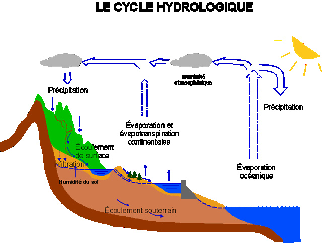
VARIATION DU NIVEAU D'EAU !!! .
À partir du moment où l’eau est apparue, elle n'a cessé d’être en mouvement et son volume total est demeuré relativement constant. En effet, la quantité initiale d'eau n'a guère augmenté, ni diminué avec le temps. Les mêmes molécules sont continuellement passées des océans et de la surface du sol à l'atmosphère par évaporation, sont tombées sur le sol sous forme de précipitations et sont retournées à la mer par les cours d'eau et les eaux souterraines. Cette circulation incessante s'appelle le « cycle hydrologique ».
***************************************
(QUESTION 5)
Et c'est ainsi que l'étang alimente naturellement le ruisseau du ....?.... , qui s'écoule vers ....?...., puis se jette dans ....?....
**************************************
RAPPEL: PAS DE BOITE A TROUVER SUR PLACE...
POUR VALIDER LE FOUND-IT: REPONDEZ AUX QUESTIONS SUIVANTES:
1) Que signifie aquifère ?
2) Noms des aquifères caractérisant le bassin versant de l’Echandon: ( voir descriptif à compléter...) ?
3) Le sénonien en Touraine est représenté par trois formations d'origine marine: lesquelles?
4) Citez les quatre étages du Sénonien et leurs périodes en MA (Millions d'années)?
5) Citez les 3 cours d'eau manquants dans le descriptif sous le shéma du cycle hydrologique?
6) Profondeur générale de l'étang et au pied de la digue ?
7) Estimez la hauteur du fossé ou l'on distingue la coupe du sol (à + ou - 10cm) ?
8) Photo optionnelle sur site...
Loguez cette cache "Found it" et envoyez-moi vos propositions de réponses soit via mon profil, soit via la messagerie geocaching.com (Message Center), et je vous contacterai en cas de problème...
 pond reeds ...
On this site, the relief is small, but with a hollow portion in its center, this small depression is the cause of this superb body of water.
Le Louroux site consists of two ponds, appointed pond Reeds and pond of Beaulieu, which have a respective area of 52 ha and 4 ha.
The main pond is the reed ...
This body of water is one of the largest in the region. And also and especially the most beautiful, which is why it is protected.
Fauna (not less than 150 species have been observed between 1972 and 1993, some very rare.) And exceptional flora make it famous.
FOLLOW THE RULES OF THE SITE DURING YOUR TRIP ...
ITS GEOLOGICAL ORIGIN:
From a geological perspective, the Louroux pond is located on a vast area of the Senonian flint clay outcropping locally on malls. These clays bordering the pond on its entire perimeter, yet being very small to the east. The geological structure of the sector is marked by the appearance of lake limestone Touraine accompanied marl. The Echandon valley typically falls within the wide range of lake limestone formations of Touraine. A picture of the pond, the bed of the river is bordered however locally clay-siliceous formations of Senonian, mainly present on the left bank.
***************************************
(QUESTION 2)
Three aquifers characterize the watershed of Echandon: - The aquifer ...... ......: he covers virtually the entire watershed - aquifer of ...... ......: it feeds the Echandon in times of water shortage, - the aquifer ......? ...... but it does not concern the study area.
********************************
On the soil standpoint, the catchment area of the pond of Louroux includes several soil types. This is mainly brown soils leached compounds silt trays of flint clay and brown limestone soils, very good. These types of substrates are both very good for cereal.
CHANGE WATER LEVEL !!! .
From the time the water has appeared, it has ceased to be in motion and its total volume has remained relatively constant. Indeed, the initial amount of water has not increased or decreased over time. The same molecules are continuously past the oceans and the soil surface to the atmosphere through evaporation, fell to the ground as precipitation and returned to the sea by rivers and groundwater. This endless circulation is called the "water cycle".
***************************************
(QUESTION 5)
>And so the pond naturally feeds the creek ....? ...., Which flows to ....? .... and then flows into ....? ....
**************************************
To validate this cache, answer the following questions:
1) What does aquifer?
2) Names of aquifers characterizing the catchment area of the Echandon: (see description to complete ...)
? 3) The Senonian Touraine is represented by three marine formations which
? 4) Name the four floors of the Senonian and their periods in MA (million years)?
5) Name the missing 3 rivers in the description under the diagram of the water cycle?
6) General Depth of the pond at the foot of the dam?
7) Estimate the height of the gap or are distinguished soil cut (to + or - 10cm)
8) Optional on-site photo ...
phones Sign the cache "Found it" and send me your answers proposals either via my profile or via email geocaching.com ( Message Center), and I will contact you in case of problems.
******************
Pour les amateurs de promenade (5km), le parcours fait le tour de l'étang avec néanmoins une partie de route (1km entre la ferme du Grand Bray et celle de Beaulieu)
******************
For lovers walk (5km), the route goes round the pond with still part of road (between 1km farm of Grand Bray and the Beaulieu)
BELLE BALADE, JE VOUS ATTENDS/BEAUTIFUL, WALKING YOU WAIT 
Additional Hints
(Decrypt)
Yr gbhe qr y'égnat rfg erpbzznaqé cbhe prggr "rnegu" nsva qr cebsvgre q'har fhcreor rg snpvyr onynqr snzvyvnyr, rg ibhf frerm pbagenvag q'ra snver nh zbvaf har cnegvr cbhe yr eryrié qh JC 7.
*************************
Gur nern nebhaq gur cbaq vf erpbzzraqrq sbe guvf "rnegu" gb rawbl n fhcreo naq rnfl snzvyl jnyx, naq lbh'yy or sbeprq gb znxr ng yrnfg cneg bs gur fgngrzrag bs JC 7.