G.C. First EarthCache: Dunas de Maspalomas EarthCache
G.C. First EarthCache: Dunas de Maspalomas
-
Difficulty:
-

-
Terrain:
-

Size:  (other)
Please note Use of geocaching.com services is subject to the terms and conditions
in our disclaimer.
This is an EarthCache so you won't find any items, box, physical cache or logbook at this site.
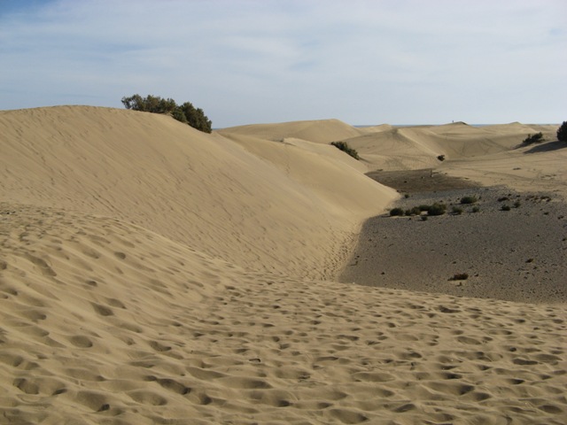
The Dunes of Maspalomas are one of the most famous sights on the south coast of Gran Canaria. The large sand waves are covering an area of 4 sqkm between Playa del Inglés and Maspalomas. Some of these sand waves can be up to 12 meter high.
Dunas de Maspalomas
Geological History
Thousands of years ago the gullies which formed the whole supply of water to The Lagoon provided abundant water and which, with the passing of time, formed an alluvial plain: a flat surface of land formed by water supplies from a river.
Afterwards glaciation lowered the sea level. The sea level dropped more on several occasions and with this descent the course and also different levels of fluvial terraces were formed. At this time, the sediments swept while the course was forming, formed a delta now covered by the sea. 
Further deglaciation processes put the sea level up. Samples of this are the different lines, or fossilised animals and plants. Today these are visible in some of the gaps between the dunes.
The situation of the delta platform produced the sand which developed the current system of the dunes.
The origin of the dunes
The dunes were formed with grains of crushed sea organisms. The ocean currents dragged them to the shore and from here the wind accumulated them behind the balancones (Traganum moquini). In this way, a little pile of sand is created and increases with the contributions from the sea, forming the first dune. This dune will eventually separate itself from the balancon when it becomes higher than the plant.
The movement of the dunes
The wind drags the sand. This constant movement stops vegetation and prevents it from taking root. Only some exemplars of the Canary Islands tamarisk which manage to exceed the maximum height of the dune can survive. Every year these mobile dunes moves 2 to 5 meters to the west.
How to log this cache?
To log this cache just answer these two simple questions and email these answers to us! You can find the answers at the info board at
N 27°44.339'
W015°35.715'
1) For what purpose were the Dunes of Maspalomas used up until the 60s ?
2) How is this district also known?
Now find your way to the dunes, make a picture on top of your favourite Maspalomas dune holding your GPSr and add this picture to your log (optional).
Note: Logs from teams emailing incorrect answers will be removed without further notice! If you think your answers are correct, feel free to log a 'Found'.
Additional Hints
(No hints available.)