Located at the end of a chain of islands that includes Mayne,
Pender, Galliano and Salt Spring, Saturna is the most southern of
all the islands and is considered by many to be the most beautiful
of them all. Much of the island, which is 31 square kilometers, is
part of the spectacular Gulf Islands Park Ecological Reserve. This
reserve was set up in 2006 to protect the land, reefs and inlets so
this valuable land would be preserved for various wild life like
the seals and the amazing assortment of birds. If you are an avid
bird watcher this is place that you must go and explore because you
will see birds migrating through here first before you will see
them in the Lower Mainland. In fact you will see the birds almost
two weeks before they start appearing in the Lower Mainland in any
great numbers.
Saturna Island was named after the Saturnina, a Spanish ship,
which explored this area in 1791 along side the famous British
cartographer Captain George Vancouver. This island grew much slower
than the other southern gulf island neighbours (Mayne, Pender, Salt
Spring & Galliano) because of its great farmland and it was the
furthest away than the other islands were for the main shipping
routes to and from Victoria and New Westminster (the original
capital of British Columbia). In fact the first farmers to the
island grew fruit trees and cows for their milk & butter but
that tradition has now evolved into a pretty big sheep industry
that still exists today.
In meteorology (the science of weather), winds are often
classified based upon their strength and the direction in which the
wind is blowing from originally. Short bursts of high-speed wind
are called gusts. Stronger winds that last around one minute or
longer are called squalls. Long-duration winds have various names
associated with their average strength and some of the most common
names are a breeze, gale, storm, hurricane, and a typhoon. Wind
occurs on a range of scales, from thunderstorm flows lasting tens
of minutes, to local breezes generated by continuous heating and
cooling of land surfaces.
The two main causes of large-scale atmospheric circulation are
the differential heating between the equator and the poles, and the
rotation of the planet (Coriolis effect). Within the tropics,
thermal low circulations over terrain and high plateaus can drive
monsoon circulations. In coastal areas the sea breeze/land breeze
cycle can define local winds and in some coastal areas that have
variable terrain heights, mountain and valley breezes can dominate
local winds to such of extent that the land is constantly being
shaped by it.
Winds can shape landforms, via a variety of Aeolian processes
such as the formation of fertile soils or the erosion of a point or
headland so there isn’t much growing soil or humus layer that
is left behind to be developed and build upon. Dust from large
deserts can be moved great distances from its source region by the
prevailing winds; winds that are accelerated by rough topography
and associated with dust outbreaks have been assigned regional
names in various parts of the world because of their significant
effects on those regions. Wind affects the spread of wildfires.
Winds disperse seeds from various plants, enabling the survival and
dispersal of those plant species, as well as flying insect
populations. When combined with cold temperatures, wind has a
negative impact on livestock. Wind affects animals' food stores, as
well as their hunting and defensive strategies.
Wind is caused by differences in pressures in the atmosphere.
When a difference in pressure exists, the air is accelerated from
higher to lower pressure zones when they meet. Whenever there are
two different pressure zones converging into each other a wind will
be the result.
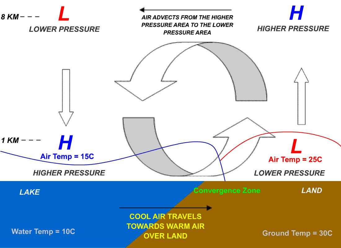
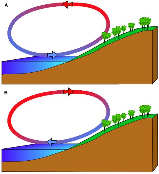
In the coastal regions sea breezes and land breezes (different
kinds of wind) can be important factors in a location's prevailing
winds and one aspect that effects the wind direction and strength
is the surface temperature. A sea-breeze (or onshore breeze) is a
wind from the sea that develops over land near coasts. It is formed
by increasing temperature differences between the land and water
which create a pressure minimum over the land due to its relative
warmth and forces higher pressure, cooler air from the sea to move
inland. Generally, air temperature gets cooler relative to nearby
locations as one move's closer to a large body of water. The sea
has a greater specific heat than land and therefore has a greater
capacity for absorbing heat than the land, so the surface of the
sea warms up slower than the land's surface. As the temperature of
the surface of the land rises, the land heats the air above it. The
warm air is less dense and so it rises. This rising air over the
land lowers the sea level pressure by about 0.2%. The cooler air
above the sea, now with higher sea level pressure, flows towards
the land into the lower pressure, creating a cooler breeze near the
coast. The strength of the sea breeze is directly proportional to
the temperature difference between the land and the sea. If the
environmental wind field is greater than 8 knots and opposing the
direction of a possible sea breeze, the sea breeze is not likely to
develop.
The sea is warmed by the sun more slowly than how fast the land
can be warmed because of because the sea simply has a much greater
volume to be affect by the heat. As the temperature of the surface
of the land rises, the land heats the air above it by conduction.
The warm air is less dense than the surrounding environment and so
it rises. This causes a pressure gradient of about 2 millibars from
the ocean to the land. The cooler air above the sea, now with
higher sea level pressure, flows inland into the lower pressure,
creating a cooler breeze near the coast. When large-scale winds are
calm, the strength of the sea breeze is directly proportional to
the temperature difference between the land mass and the sea. If an
offshore wind of 8 knots (15 km/h) exists, the sea breeze is not
likely to develop.
At night, the land cools off more quickly than the ocean because
of differences in their specific heat values. This temperature
change causes the daytime sea breeze to dissipate. When the
temperature onshore cools below the temperature offshore, the
pressure over the water will be lower than that of the land,
establishing a land breeze, as long as an onshore wind is not
strong enough to oppose it.
Wind erodes the Earth's surface by deflation (the removal of
loose, fine-grained particles), by the turbulent eddy action of the
wind and by abrasion (the wearing down of surfaces by the grinding
action and sandblasting of windborne particles). Regions that
experience intense and sustained erosion are called deflation
zones. Most Aeolian (wind) deflation zones are composed of desert
pavement, a sheet-like surface of rock fragments that remains after
wind and water have removed the fine particles. Almost half of
Earth's desert surfaces are stony deflation zones. The rock mantle
in desert pavements protects the underlying material from
deflation. However, this isn’t just limited to the desert and
it can be in fact being found along the ocean and a headland.
Questions for the Earthcache
1. Take a picture of yourself and or your GPS at ground
zero
2. Include a picture that shows how the rocks are being worn down
by the wind and then another picture that shows how the wind has
directly affect the landscape
3. Explain why you think there are so few trees, grass, salal
bushes etc that are currently growing at this location OR why you
think there is very little water for the plants can use to grow
from
4. Was it windy when you there and if it was how windy was
it?
5. From ground zero you will find a plaque for which the island is
named after. Once you have found plaque tell me the answer as to
what was the exact year, date and month did the Spanish expedition
land on this point and who exactly spotted this land?
When you have all of the answers email your answers for
questions 2 - 5 to me. Once I have gotten back to you to tell you
if they are correct or not you may then go post your find as well
as your picture on the public log if you wish.
| I am a proud |
 |
| I am a proud |
 |
Proudly Supported By:
| I am a proud |
 |
Proudly Supported By: