Greenbrier County West Virginia is one of the most beautiful places you can visit. The Western part of the county is typical of much of the state with primarily sandstone and shale. However, Eastern Greenbrier County is textbook karst topography with underground streams, caves and sinkholes. There is a wealth of water in the county although delicious sweet water may be only a few miles from wells with noxious sulfur water.
A karst aquifer is roughly analogous to a roofed-over creek. In comparison, granular or fractured bedrock aquifers have no equivalent "underground river" or channel. The drainage patterns of karst conduits resemble the branching pattern formed by streams flowing above ground across insoluble rocks. We are prevented from seeing the branching pattern of karst conduits because the streams are below ground. The disrupted topography of a karst terrain also prevents us from easily seeing on the surface the now-abandoned channels, relics that once carried water before the limestone dissolved. In karst aquifers, the conduits and caves drain the pore space between the limestone grains (intergranular or primary porosity) and the fractures (secondary porosity) formed by joints, bedding planes, and faults. The unconsolidated cover over the bedrock, narrow fractures in the bedrock, small conduits, and larger cave passages collectively form a karst aquifer. The openings forming the karst aquifer may be partly or completely water-filled. The elevation where all pores are filled with water in an aquifer is the water table. The water tables in karst areas can be highly irregular in elevation, however, because water-carrying conduits can develop at various elevations. Water may also be encountered in perched aquifers -- aquifers that are elevated above the lower, regional water table by less soluble, impermeable beds.
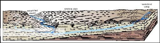
A karst spring receives drainage from all the sinkholes and sinking streams within its groundwater basin, equivalent to a watershed on the surface. The conduits carrying water from each point where water sinks join together underground to form successively larger passages with ever-increasing flow, which eventually discharges at a spring. An important way that karst aquifers differ from other aquifers is that a groundwater basin boundary may have little relationship to surface watershed boundaries. A stream flowing on the surface simultaneously shifts the watershed boundary as it erodes headward. When a cave stream erodes headward, however, it can extend beneath a ridge, leaving the surface unmodified, to capture flow from the adjacent watershed. Therefore, the actual watershed area of a karst spring may be much larger, or smaller, than is apparent from topographic maps. Sinkholes and valleys in the area may seem to be in one watershed yet drain to a far-away spring.
This roadside spring has a convenient pull off area when locals frequently stop and fill water jugs with the quality water coming from the hillside. Although, I wouldn’t advise drinking the water straight from the hillside, everyone in the area says that it is the best tasting water you can find.
I filled a 4 liter bucket at the spring in 5 seconds. Use that information to determine the magnitude of the spring. Shoot an elevation of the spring..
|
Magnitude
|
Flow (L/s)
|
|
1st Magnitude
|
2800 L/s
|
|
2nd Magnitude
|
280 to 2800 L/s
|
|
3rd Magnitude
|
28 to 280 L/s
|
|
4th Magnitude
|
6.3 to 28 L/s
|
|
5th Magnitude
|
0.63 to 6.3 L/s
|
|
6th Magnitude
|
63 to 630 mL/s
|
|
7th Magnitude
|
8 to 63 mL/s
|
|
8th Magnitude
|
8 mL/s
|
|
0 Magnitude
|
No flow
|
When you visit the Earthcache, email the the following information:
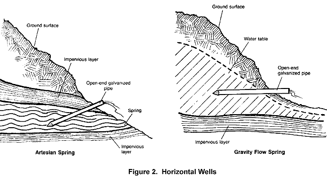
1. The magnitude of the spring
2. Whether it is artesian or gravity fed
3. The elevation of the spring where it emerges from the hillside.
Although not required, photos you and/or your GPSr at the cache with the spring in the background are appreciated. p>