#031 - Barrier of Sand EarthCache
-
Difficulty:
-

-
Terrain:
-

Size:  (not chosen)
Please note Use of geocaching.com services is subject to the terms and conditions
in our disclaimer.
Welcome to the Barrier
of Sand

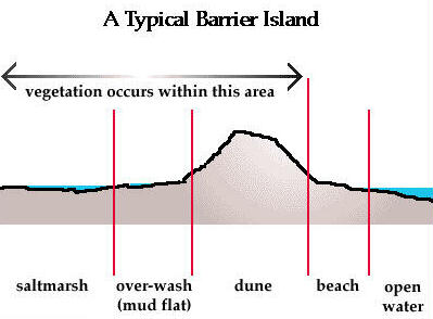
Barrier islands are massive dunes. Their bases lie below the
tideline, and their peaks barely reach
3 meters – or about 10 feet – above low tide. These ribbons of sand
were formed by huge storms,
and they help buffer the coast from wave erosion. The islands stay
above water by migrating up the gentle
slope of the coastal plain. A barrier island has a sole function of
absorbing the wave energy. If you have
a low enough flow and if you have sand, you will build a beach that
functions to absorb wave energy. Steep
vertical cliffs and rocky shorelines do not support the forming of
sandy beaches or barrier islands. Barrier
islands form where there are gentle coastlines with lots of sand
available but not equally available. These
low-lying islands struggle against rising sea levels that started
10,000 years ago when the climate warmed
dramatically after the last ice age. A common type of barrier
island is called an “overwash”
island. When severe storms strike a beach, the waves wash over
dunes and the sands fan out toward the back
side of the island. As the front side erodes, the back side gains
sand. In such a case the beach may erode 200 ft
or so, unless prevented by stationary dunes and bulkheads. If you
prevent overwash, you prevent the renourishment
of the backside of the barrier, which is what the barrier will roll
over on in response to rising sea levels.
On a daily basis erosion is happening on barrier islands. When
water intersects land it moves sand around.
Waves are an efficient sand mover. There are many cycles and scales
on which a barrier island moves. On calm days,
waves slowly move sand back in. Storms pull sand off again. The
island gradually rolls over on itself.
This natural system is disrupted and the whole dynamics have
changed when people build artificial dunes to
protect beach homes and roads, and develop and build homes on top
of the existing dunes. They stop the
natural mechanics of barrier island overwashing and rolling over on
themselves.
Now there are TWO TASKS I
want you to do in order to claim this
Earthcache.
TASK
ONE
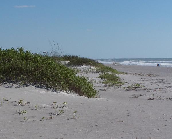
Take a look at the picture above.
The picture shows the profile of the first three dunes of the
typical barrier island dune system.
Go to N27 22.686 W082
38.112
and take a picture of yourself in front of those dunes and post it
with your log at this listing.
This was TASK ONE.
TASK
TWO
Now you need to utilize the distance measurement function of your
GPS or you must improvise an alternate method of length measurement
(feet?).
I want you to measure the total distance
commencing at the Start
Point at N27 22.677 W082 38.141 on the Gulfside
Beach
going through the Midway
Waypoint at N27 22.704 W082 38.078
and arriving at the End
Point at N27 22.714 W082 38.041 on the Bayside
Shoreline.
Arrived at the end point you will see the following scene:
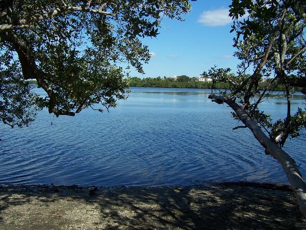
Take note of the measured distance and email me your measurement
when you post your log so I can verify you have been here.
The measurements must be in feet or meters. This was TASK TWO.
For your reference and comparison, Longboat Key measures 1.01 mile
at its widest east-west distance.
Looking forward hearing from you.
Happy Earthcaching!

Additional Hints
(No hints available.)