Printmodus:
Englisch on/off
Türkisch on/off
German on/off
 English Version [Deutsche
Übersetzung unten / Türkçe versiyonu asagida]
English Version [Deutsche
Übersetzung unten / Türkçe versiyonu asagida]
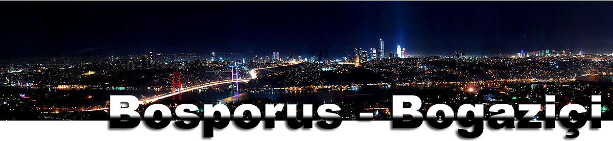
The
Bosporus
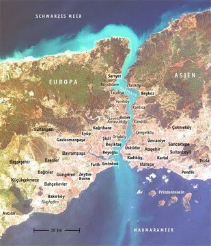
The Bosporus is the connection between the
Marmara Sea in the south and the Black Sea in the north. It is a
part of the border between Europe and Asia. On both sides of the
strait the city of Istanbul applies. At the southern end lies the
Golden Horn, the harbour bay of the former capital of the osmanian
empire, one of the biggest physical harbours of the
world.
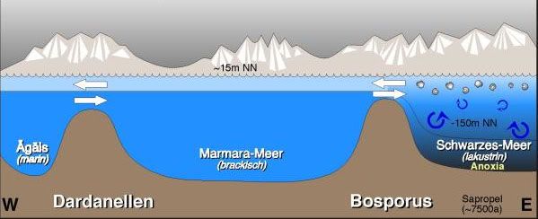
About the origin of the Bosporus there are
two theories about which the scientists argue until
today.
 |
|
The biblical
flood
Following the theory of two American
geologists, the biblical flood has its origin at the Bosporus.
Place of the flood was the Black Sea that had dried up after the
last ice age to a salty brackish water lake. A connection with the
oceans did not exist. 7500 years ago the rock dam suddenly broke,
which had held back the glaze floods in the Mediterranean Sea. The
water flowed out years with high pressure through the rock tube
between Asia and Europe, making the level of the Black Sea rise by
15 centimetres each day. A leveling of the seas resulted. The
people fled before the floods – the event engraved so deeply
into the collective memory, that the biblical flood myth took its
origin.
Gradual
increase
Another theory claims, the rivers Danube,
Don and Dnjepr poured into the Black Sea. They all led large
amounts of melt water. The sea rose and slowly ran over, resulting
in a flood. Nevertheless, this was far less spectacular than in the
first scenario. During about thousand years the water about the
Bosporus threshold flows out by a deep gulch in the just twenty
metre deeper situated Marmara Sea.
|
|
Two
currents
So conflicting as the theories of its
history, are the two currents are of the Bosporus. One flows in the
surface and a weaker undercurrent in about 40 metre depth. The
upper stream comes from the Black Sea. It is less salty and -
hence - lighter. It flows to the lower situated Marmarameer. The
unterstream flows with its saltier water in opposite
direction.
|
|
 |
 |
|
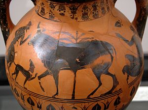
Naming
Bosporus means translated "cattle
ford” or “cow ford" - a name with mythological origin.
God's father Zeus fell in love with the nice Io, one of the priests
of his wife Hera. He kidnapped her and transformed her into a cow
to hide her from his jealous spouse. But Hera noticed the cheat and
sent a gadfly after Io, who escaped in her animal figure. On the
escape, the beauty crossed the ford between Asia and Europe, which,
from now on, got its name.
|
Log-Conditions:
-
Answer the
following questions and send the answers in a mail. You do not have to wait for
admittance, if something is wrong, I’ll contact
you.
-
Take a photo of
you or your GPS at a point with a scenic view over the
Bosporus. The given coordinates
lead to the
beautiful terrace
in the courtyard of the Topkapi-palace. If you do not want to pay
the access fee, you may also answer the questions from the Kennedy Cd.
Questions:
-
Look to the asian side oft the Bosporus. Guess how far it is to the other side at this
place. By
the way: The Bosporus is – on it’s thinest spot
about 700 meters wide and about 2.5 kilometer at it’s
widest.
-
How many mountain peaks do you see on the other side? Describe
them.
-
Take some time
and watch the ships passing by – and also those waiting for
passage. What do you think: How many ships pass the straight each
day?
-
In which
direction the wind has to blow, to change the surface flow of the
Bosporus?
-
What are the
names oft he two american geologists setting up the
biblical-flood-theory?
 Türkçe versiyonu [Deutsche
Übersetzung unten / English Version above]
Türkçe versiyonu [Deutsche
Übersetzung unten / English Version above]
Istanbul Bogazi
Istanbul Bogazi, kuzeydeki Karadeniz ile
guneydeki Marmara Denizi'ni birbirine baglar. Bogaz, Asya ile
Avrupa arasindaki sinirin da bir parcasidir. Bogazin her iki
yakasinda da Istanbul sehri yer alir. Bogazin guney ucunda, Halic
yani Osmanli Ýmparatorlugunun bas sehrinin limani bulunur. Halic
dunyanin en buyuk limanlarindan biridir.
Istanbul Bogazi'nin olusumu hakkinda, bugun bile bilim adamlarinin
uzerinde anlasamadigi iki teori vardir.
|
|
Tufan
Ýki amerikali jeolog'a gore, Incil'deki
tufan'in kaynagi Istanbul Bogazi'dir. Tufan'in olus yeri
Karadeniz'dir. Karadeniz son buzul devrinden sonra kuruyarak aci ve
tuzlu kucuk bir gole donusmustu. Okyanuslarla baglantisi yoktu.
7500 yil once kayalik duvar aniden coktu ve su Avrupa ile Asya
arasindaki kayalik oluktan yuksek basincla akmaya basladi. Oyle ki,
Karadeniz'in seviyesi her gun 15 santimetre kadar yukseldi.
Sonunda, denizlerin seviyesi esitlendi. Su baskini baslamadan once
insanlar kacmisti ancak olay ortak insanlik hafizasinda oyle yer
etti ki, sonradan Ýncil'deki Tufan efsanesine kaynak
olusturdu.
Birikim tasintisi
Baska bir teoriye gore, Tuna, Don ve Dinyeper
nehirleri Karadeniz'e akiyorlardi. Hepsi de Karadeniz'e buyuk
miktarda eriyen karlarin suyunu getiriyordu. Deniz seviyesi zaman
icinde yukseldi ve su baskinlari yapacak sekilde tasti. Ama bu
tasintinin sonuclari ilk senaryo'ya gore daha az carpici oldu.
Yaklasik bin sene boyunca su Bogaz seviyesindeki derin bir kanaldan
yirmi metre asagidaki Marmara Denizi'ne akti.
|
|
Ýki
akinti
Olusumundaki hikayeler ne kadar celiskili ise,
Bogazdaki iki akinti da o olcude birbirine zittir. Akintilardan
biri yuzeydedir. Daha zayif bir alt akinti ise yaklasik 40 metre
derinden akar. Ustteki akinti Karadeniz'den gelir. Daha az tuzlu,
dolayisi ile daha hafiftir. Bu akinti daha asagi seviyedeki Marmara
Denizi'ne akar. Alttaki akim ise daha tuzlu sulari ile ters yone
akar.
|
|
|
|
|
Isimlendirme
"Bosphorus" mitolojik bir anlami olan inek
veya davar gecidi anlamina gelir. Mitolojik hikayede, bastanri Zeus
guzel bir kiz olan ve karisi Hera'nin rahibelerinden biri olan
Io'ya gonlunu kaptirir. Zeus kiskanc karisindan saklamak icin bir
gun Io'yu kacirir ve onu inege cevirir. Ama Hera hileyi sezer ve
bir atsinegini inek suretine burunup kacan Io'nun pesine surer.
Kacisi esanasinda Io, Asya ile Avrupa arasindaki gecitten gecer.
Ýsim o zamanlar ve bu hikayeden gelir.
|
Kayit yazma sartlari:
-
Asagidaki sorulari cevaplayip, cevaplarinizi
bir e-posta ile bana yollayin. Kabul icin beklemenize gerek yok.
Cevaplarda yanlis varsa size haber veririm.
-
Kendinizin veya GPS cihazinizin
Bogazi gorecek sekilde bir manzara icinde fotografini cekin.
Verilmis olan koordinatlar sizi Topkapi Sarayi bahcesindeki guzelim
teras'a goturur ama Topkapi Sarayina giris ucretini vermek
istemiyorsaniz, cevaplari Kennedy Caddesinden de
verebilirsiniz.
Sorular:
-
Bogazin Asya tarafina dogru bakin. Karsi taraf
bu noktadan kac metre uzaktadir, tahmin edebilir misiniz? Bogaz en
dar noktada 700 metre enindedir. Bogazin en genis yeri ise 2,5
km'dir.
-
Karsi yakada kac adet tepe goruyorsunuz.
Anlatabilir misiniz.
-
Gecen gemileri ve gecis sirasi bekleyenleri
biraz gozlemleyin. Ne dersiniz : Bogazdan gunde kac gemi
geciyordur?
-
Yuzey akimini degistirmek icin ruzgar hangi
yonde esmelidir?
-
Incildeki Tufan teorisini kuran iki amerikali
jeologun adlari nedir?
Thanks to ustune for translating this cache
into Turkish!
 Deutsche Version [English
translation above / Türkçe versiyonu yukarida]
Deutsche Version [English
translation above / Türkçe versiyonu yukarida]
Der
Bosporus
Die Verbindung zwischen
Marmarameer im Süden und Schwarzem Meer im Norden stellt der
Bosporus dar. Er ist Teil der Grenze zwischen Europa und Asien. Auf
beiden Seiten der Meerenge erstreckt sich die Stadt Istanbul. Am
südlichen Ende liegt das Goldene Horn, die Hafenbucht der
ehemaligen Hauptstadt des osmanischen Reichs, einer der größten
Naturhäfen der Welt.
Über die Entstehung des Bosporus
gibt es zwei Theorien, über die sich die Wissenschaftler bis heute
streiten.
|
|
Die
biblische Flut
Der Theorie zweier
amerikanischer Geologen nach hat die Sintflut-Geschichte aus der
Bibel ihren Ursprung am Bosporus. Ort der Überschwemmung war das
Schwarze Meer, dass nach der letzten Eiszeit zu einem salzigen
Brackwassersee eingetrocknet war. Eine Verbindung zu den Weltmeeren
bestand nicht. Vor 7500 Jahren sei dann plötzlich der Gesteinsdamm
am Bosporus gebrochen, der die Schmelzfluten bis dahin im
Mittelmeer zurück gehalten hatte. Das Wasser strömte ein Jahre lang
mit Hochdruck durch den Felsenschlauch zwischen Asien und Europa,
der Pegel des Schwarzen Meeres stieg täglich um 15 Zentimeter. Ein
Gleichstand der Meeresbecken wurde hergestellt. Die Menschen flohen
vor den Fluten – das Ereignis brannte sich so tief in das
kollektive Gedächtnis ein, dass der biblische Sintflutmythos
entstand.
Allmählicher Anstieg
Einer anderen Theorie nach
ergossen sich die Flüsse Donau, Don und Dnjepr ins Schwarze Meer.
Sie alle führten große Mengen Schmelzwasser mit sich. Das Meer
stieg an und lief langsam über. Es gab also eine Überschwemmung.
Diese war jedoch weit weniger spektakulär als im ersten Szenario.
Etwa tausend Jahre lang strömt das Wasser über die Bosporusschwelle
durch eine tiefe Schlucht in das knapp zwanzig Meter tiefer
gelegene Marmarameer.
|
|
Zwei
Strömungen
So zwiespältig wie seine
Entstehungsgeschichte sind auch die Strömungen im Bosporus. Eine
fließt an der Oberfläche und eine schwächere Unterströmung in zirka
40 Metern Tiefe. Der Oberstrom stammt aus dem Schwarzen Meer. Er
ist weniger salzhaltig und daher leichter. Er fließt zum niedriger
gelegenen Marmarameer. Der Unterstrom fließt mit seinem
salzhaltigeren Wasser in entgegengesetzter Richtung.
|
|
|
|
|
Namensgebung
Bosporus bedeutet übersetzt
"Rinder- oder Kuhfurt" - ein Name mit mythologischem Ursprung.
Göttervater Zeus verliebte sich in die schöne Io, eine der
Priesterinnen seiner Frau Hera. Er entführte sie und verwandelte
sie in eine Kuh, um sie vor seiner eifersüchtigen Gemahlin zu
verstecken. Diese bemerkte den Schwindel und schickte Io, die in
Tiergestalt geflohen war, eine Bremse hinterher. Auf ihrer Flucht
durchquerte die Schöne die Furt zwischen Asien und Europa, die ihr
daher ihren Namen verdankt.
|
Log-Bedingungen:
-
Beantworte folgende Fragen und
sende mir die Antworten in einer E-Mail. Du brauchst nicht auf mein
Ok warten, sondern kannst einfach loggen. Falls etwas nicht stimmt,
dann werde ich mich melden.
-
Mache ein Foto von
Dir oder Deinem GPS an einem Punkt mit tollem Ausblick über den
Bosporus. Die oben genannten Koordinaten befinden sich auf der
wunderschönen Aussichtsterrasse im Innenhof des Topkapi-Palastes.
Wer keinen Eintritt zahlen möchte, kann die Fragen auch von der
Kennedy Cd. aus lösen.
Fragen:
-
Schau hinüber auf die asiatische
Seite. Schätze, wie breit der Bosporus an den oben genannten
Koordinaten ist. Übrigens: Die Meerenge ist an ihrer schmalsten
Stelle 700 Meter und an der breitesten bis zu 2,5 Kilometer
breit.
-
Wie viele Bergkuppen siehst du
auf der gegenüberliegenden Seite? Beschreibe sie.
-
Nimm Dir Zeit und beobachte eine
Weile die vorbeiziehenden und vor allem die auf die Passage
wartenden Schiffe. Was vermutest Du: Wieviele Schiffe passieren
täglich die Meerenge?
-
In welche Himmelsrichtung muss
der Wind wehen, damit sich die Oberflächenströmung des Bosporus
ändert?
-
Wie heißen die beiden
amerikanischen Geologen, die die Sintflut-Theorie aufgestellt
haben?