Die Hörschbachschlucht bei Murrhardt (Rems-Murr-Kreis)

[GER]
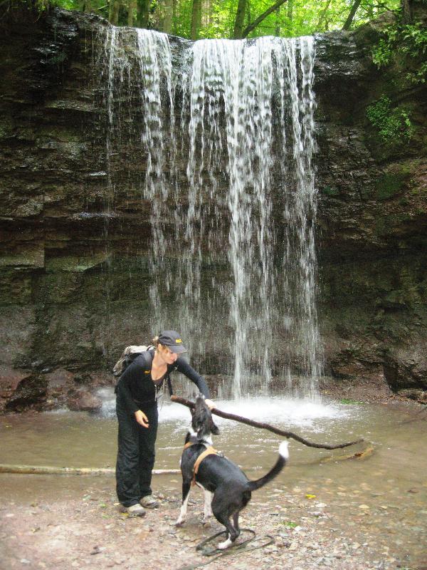
Die Hörschbachschlucht bietet dem Besucher eine ganze Reihe von natürlich entstandenen geologischen Aufschlüssen mit markanten Felsbildungen. Mähderbach und Langenwaldbach bilden durch ihren Zusammenfluss den Hörschbach, dieser fließt unmittelbar nach seinem Entstehen durch die Schlucht, die schon früh die Menschen durch ihre Schönheit beeindruckt hat. So wie den Vorderen Wasserfall (siehe Bild) bei N48°58.304 E009°33.255, der ca. 5 Meter tief über die sog. "Engelhofer Platte" herabstürzt. Besonders beeindruckend ist der Anblick des Vorderen Wasserfalls im Winter, wenn das Geotop zu Eis erstarrt ist.
Der Hintere Wasserfall bei N48°57.493 E009°32.948 stürzt zunächst 3 m senkrecht über eine Schilfsandsteinstufe nach unten und fließt im Anschluss in mehreren Kaskaden weitere 12 m über die Schichten der Bunten Mergel in Richtung Murrhardt. Dort mündet er in die von Osten kommende Murr. Für Kinder und welche die es immer noch sind hat der hintere Wasserfall eine Besonderheit. Durch einen Schieber lässt sich oberhalb des Wasserfalls ein Becken mit Wasser stauen, welches sich dann in einen riesigen Schwall über die Kante des Wasserfalls entleert!
 Der schmale Talgrund der Hörschbachschlucht ist gefüllt mit zahlreichen Schilfsandsteinblöcken, die im Laufe der Zeit von den Schluchthängen herabgestürzt sind. Deutlich ist dies auf dem Teilstück des Weges zwischen N48°57.635 E009°32.951 und N48°57.601 E009°32.937 zu sehen. Der Schluchtwald ist als Schonwald ausgewiesen und soll sich ohne Eingriff des Menschen auf natürliche Weise weiter entwickeln.
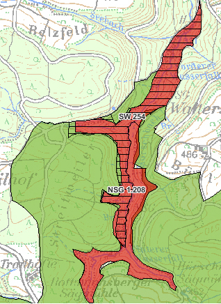
Teilbereiche der Schlucht wurden 1991 als Naturschutzgebiet (siehe Bild) ausgewiesen. Die geschützte Fläche hat eine Größe von rund 46 ha. Die Hörschbachschlucht ist durch einen Fußpfad gut erschlossen und kann mit einen 5 km langen Rundweg erkundet werden. Der Weg ist sehr Anspruchsvoll und nur mit guten Schuhwerk zu machen.
Um diesen Cache loggen zu können, musst du folgende Aufgaben erledigen:
Macht nach Möglichkeit bei N 48° 58.304 E009°33.255 ein Bild von euch mit dem Wasserfall im Hintergrund. Ein weiteres Bild könnt ihr bei den Markanten Felsblöcken bei N48°57.635 E009°32.951machen.
Fügt diese Bilder zu euren Log hinzu.
In der Nähe des Parkplatzes findet ihr eine Tafel welche euch über die Schlucht Informiert. Beantwortet folgende 2 Fragen.
1. Für welche selten gewordenen Tierarten bietet die Hörschbachschlucht einen Lebensraum?
2. Die Farbskala vom harten Sandstein bis zum tonigen Mergel hat welche Farben? (im Text)
Sendet eine Mail mit euren Nickname an mein Profil. Ihr bekommt schnellst möglich eine Antwort mit der Logfreigabe.

[ENG]
A whole series of course resulted geologic explanations with striking rock educations offers the "Hörschbachschlucht" to the visitor. "Mähderbach" and "Langenwaldbach" form the "Hörschbach" by her confluence, this flows immediately after his forming by the gulch which has impressed quite early the people by her beauty. As well as the front waterfall (see picture) with N48°58.304 E009°33.255 which falls off approx. 5 metres deep about the so-called "Engelhofer Platte ". The sight of the front waterfall in winter is especially impressive if the geotop has solidified to ice.
The rear waterfall with N48°57.493 E009°32.948 overthrows first 3 metres vertically about a reed sandstone step down and flows in the connection in several cascades other 12 m about the layers of the coloured marls in the direction of Murrhardt. There he flows into the grumbling coming from the east. For children and which it still are the rear waterfall has a specific feature. By a racketeer can be stopped above the waterfall a washbasin with water which empties itself then in a gigantic flood about the edge of the waterfall!
Narrow Suet-around of the "Hörschbachschlucht" is filled with numerous reed sandstone blocks which have fallen off in the course of the time of the gulch slopes. Clearly this is to be seen on the section of the way between N48°57.635 E009°32.951 and N48°57.601 E009°32.937. The gulch wood should develop without intervention of the person in natural manner.
Subranges of the gulch were expelled in 1991 as a nature reserve (see picture). The protected surface has a size of about 46 ha. The "Hörschbachschlucht" is well opened by a footpath and can be explored with a 5-km-long Flatly. The way is very demanding and to make only with good footwear.
In order to log this cache you must do the following:
Make a picture of you with the waterfall in the background with N48°58.304 E009°33.255 You make another picture with the striking boulders with N48°57.635 E009°32.951.
Adds these pictures to your log.
Near the parking area you can find a board which to you about the gulch informed. Answered the following 2 questions.
1. For whiche rare animal species, the Hörschbachschlucht provides a habitat?
2. The color scale of the hard sandstone to the clayey marl has colors? (two colors in the text)
Send a Mail to my profile. You will immediately get an answer with the log release.
